This item has been sold, but you can get on the Waitlist to be notified if another example becomes available, or purchase a digital scan.
1890 Wisconsin Central Railroad Map of the Northern United States
WisconsinCentral-wisconsincentral-1890$250.00


Title
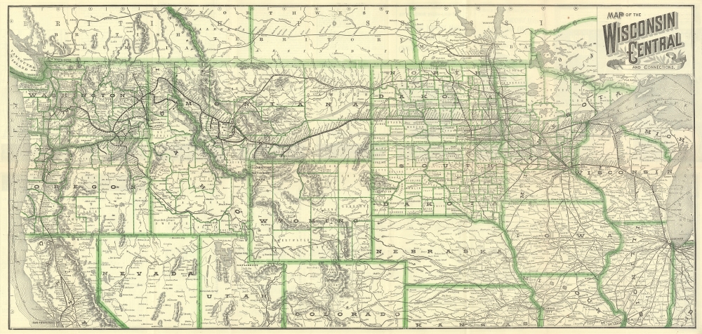
Map of the Wisconsin Central and Connections.
1890 (dated) 15.375 x 32.5 in (39.0525 x 82.55 cm) 1 : 3750000
1890 (dated) 15.375 x 32.5 in (39.0525 x 82.55 cm) 1 : 3750000
Description
This is an 1890 Wisconsin Central Railroad map of the northern United States. It traces the last years of the American Railroad boom leading up to the Panic of 1893.
A Closer Look
The map traces the Wisconsin Central Railroad's route through Wisconsin, connecting cities throughout Wisconsin with St. Paul, Minnesota; Superior, Wisconsin; and Chicago, Illinois. Published the year after the Northern Pacific Railroad leased the Wisconsin Central, no differentiation is made between the two networks. Thin lines trace connecting railroads, with an emphasis on networks based out of Chicago and Minneapolis-St. Paul.The Wisconsin Central Railroad
The Wisconsin Central Railroad operated in northern Wisconsin from 1871 until 1899. The railroad connected smaller cities and towns in Wisconsin with St. Paul and Chicago. The Wisconsin Central began as two separate railroads, both founded in 1866: the Winnebago and Lake Superior Railroad Company and the Portage and Superior Railroad Company. Both were founded to capitalize on land grants offered to railroad companies for successfully building a railroad through northern Wisconsin. The two railroads consolidated in 1869. The Portage, Winnebago, and Superior Railroad Company changed its name of the Wisconsin Central Railroad Company in 1871. Construction on the Wisconsin Central began in West Menasha, Wisconsin, on June 15, 1871, and continued in fits and starts. During 1871, 63 miles of track connecting Menasha and Stevens Point were completed, but construction woes beset the company after the 1872 season. The railroad soon encountered financial difficulty and pay disputes with its workers. This led to the 'Ashland War', when the Bayfield militia was called to restore order in Ashland, Wisconsin, and escort the 1,000 angry unpaid Wisconsin Central employees 80 miles to Superior. The Panic of 1873 exacerbated the Wisconsin Central's financial situation, and construction did not resume until 1875 or 1876. Nonetheless, in 1877 the line reached Ashland, followed by St. Paul in 1884, and Chicago in 1886. The Northern Pacific Railway leased the line from 1889 to 1893, when the Northern Pacific Railway filed for bankruptcy due to the Panic of 1893. In 1897, the Wisconsin Central Railroad was reorganized as the Wisconsin Central Railway.Publication History
This map was published by the Wisconsin Central Railroad and printed by the Corbitt and Skidmore Company in Milwaukee, Wisconsin, in 1890. This is the only known surviving example of the 1890 edition.Cartographer
Shen Shiqiu (沈士秋; fl. c. 1920 - 1932) was a Chinese painter, bookseller, and publisher active in Shanghai curing the first half of the 20th century. More by this mapmaker...
Condition
Very good. Exhibits light wear along original fold lines. Printed maps, timetables, and route information on verso.