This item has been sold, but you can get on the Waitlist to be notified if another example becomes available.
1858 Set of Two Pelton Wall Maps, Western Hemisphere and Eastern Hemisphere
World-pelton-1858$3,000.00

Title
Pelton's Political & Physical Map of the Western Hemisphere. / Pelton's Political & Physical Map of the Eastern Hemisphere.
1858 (dated) 80 x 80 in (203.2 x 203.2 cm)
1858 (dated) 80 x 80 in (203.2 x 203.2 cm)
Description
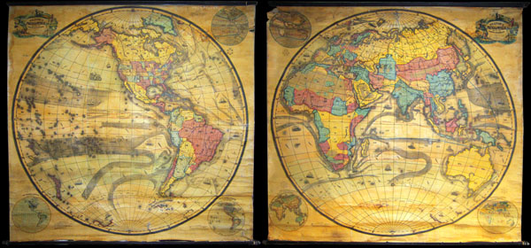
A mammoth, extremely rare, and highly desirable set of hemisphere wall maps issued by C. Pelton in 1858. These spectacular wall maps rarely appear on the market and almost never as a set. Depicts the entire world on a hemisphere projection. On both maps, countries and in some cases states are colored coded and numbered. Mountain ranges and currents are drawn in wonderful detail. In both cases numerous oceanic vessels ply the seas. These maps were originally issued for educational purposes and were accompanied by a handbook or workbook for teachers. This book acted as a key to the maps and as a guide to using the maps in classroom instruction. Both maps also bear a similar title cartouche. A European reading sits atop the cartouche. In less enlightened circumstances, surrounding the cartouche are, clockwise from the top, a North American Indian, an African man, an Aboriginal Australian, and an Asian.
The left map focuses on the Western Hemisphere detailing North America, South America, the West Indies, and parts of the Pacific basin. The U.S. is presented according to the political situation in the late 1850s. Nebraska extends north to the Canadian border. New Mexico and Arizona are a single territory, as are Utah and Nevada. Washington and Oregon extend eastward as far as the Rocky Mountains. Idaho, Montana, West Virginia, South Dakota, North Dakota, Wyoming and Colorado have yet to appear.
The right hand map focuses on the Eastern Hemisphere including Europe, Asia, Africa, Australia, and parts of the Pacific basin. A large decorative title cartouche sits in the upper right quadrant.
Both maps were designed by C. Pelton, lithographed by Wagner & M'Guigan, and published by Sower & Barnes of 33 north 3rd Street, Phildelphia, PA.
CartographerS
Cale Pelton (1811 - September 12, 1853) was a 19th century American publisher of maps and educations material for schools and academies. Born in Buckland, Franklin, Massachusetts to parents Cale Pelton and Esther Crittenden. Pelton was a good and successful teacher and author, specializeing in Outline Maps - maps without textual labels used to test and teach school children geography. He also compiled teacher's aids and geographic text books. Pelton was well regarded in his field for the size and beauty of his school wall maps as well as for the effectiveness of his textbooks. Pelton was the author of Pelton’s Outline Maps, published by Sower, Potts, and Company and used extensively in schools. He graduated from Yale College in 1840 and was a member the Yale debating group, Society of Brothers in Unity. He married Ann Ferrier Wood in 1842, who died in childbirth on February 20, 1846. He died of consumption on September 12, 1853 in Philadelphia, Pennsylvania. More by this mapmaker...
Christopher Sower (1693 - 1758) was born in 1693 in Laasphe, a small town near Witgenstein and Marburg, Germany. In 1724 Sower became one of the first German immigrants to settle with his family in Pennsylvania at William Penn's invitation. Though educated as a doctor in Marburg and later in Halle, on coming to America Sower saw a need for German language publications and set himself up as a printer. In 1743 he published the first American quarto edition of the Bible in German. Around 1753 Sower passed the company to his son, Christopher Sower Jr. (1721 - 1758). The younger Sower republished the Sower Bible in 1776 on the eve of the American Revolutionary War. Apparently the Sower warehouse was discovered by the British who found that the heavy cotton rag paper used for the Bible made excellent gun wadding. Christopher Sower nonetheless continued publishing through the Revolutionary War and eventually passed the business to his son, David Sower. The Sower publishing firm eventually passed through several generations of the Sower family before being permanently relocated to Philadelphia in 1844 by Charles Sower. In Philadelphia, Sower partnered with William H. Barnes and renamed the company Sower, Barnes & Co., later as Sower, Barnes, & Potts., and then as Sower, Potts & Co. Finally in 1888, 150 years after Christopher Sower built his first press, the firm returned to its roots and was incorporated as the Christopher Sower Company. (The Publisher's Weekly, No. 1411, Feb 11, 1899, "A Memorial to a Colonial Printer and Bookseller", p 295- 296.) Learn More...
Thomas S. Wagner and M'Guigan (fl. 1846 - 1858) were Philadelphia based publishers and lithographers active in the mid 19th century. The Wagner and M'Guigan (or McGuigan) firm were general interest lithographers and as such their work consisted of portraits, bookplates, advertisements and views as well as map. The firm was also an early pioneer of color lithography and for this were awarded a Silver Medal by the Franklin Institute in the 1840s. The Wagner and M'Guigan firm succeeded the Pinkerton, Wagner and M'Guigan firm. Learn More...
Source
Associated with Pelton, C., Key to Pelton's New and Imporvied Series of Outline Maps. Designed for Schools and Academies., 1852. Also with Pelton, C., Key to Pelton's Hemispheres. Designed for Schools and Academies., 1851.
Condition
Generally speaking both of these maps are in good condition, however, they would seriously benefit from full wall map restoration. Each map has several small holes, whitening, and a few minor tears. However, generally speaking they lack many of the more serious problems facing old wall maps. Both are free of major stains or discolorations, are intact, and maintain most of their structural integrity. Color is bright and vivid. Original rollers.
References
Phillip, P. L., A List of Amap of America in the Library of Congress, p. 1001.