This item has been sold, but you can get on the Waitlist to be notified if another example becomes available, or purchase a digital scan.
1754 Gabriel Ramirez Map of the World in Hemispheres
World-ramirez-1754$175.00

Title
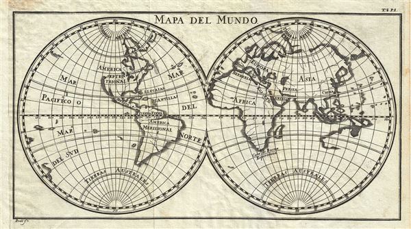
Mapa del Mundo.
1754 (undated) 6 x 10.5 in (15.24 x 26.67 cm) 1 : 200000000
1754 (undated) 6 x 10.5 in (15.24 x 26.67 cm) 1 : 200000000
Description
This is a scarce 1754 map of the World in two hemispheres by Gabriel Ramirez. It covers the western and eastern hemispheres and depicts the world as it was understood in the middle part of the 18th century, before the explorations of Cook, Wilkes, and others. The map names the continents of Asia, Europe, Africa, North America and South America with limited inland detail. Major rivers are noted, though most are speculative.
This map is interesting for its treatment of the western coast of America, the Pacific, and more importantly, Australia. This map was issued during a dark period in Australian exploration, the seventy-some years between the navigations of William Dampier in 1699 and Tobias Furneaux in 1773. Consequently most of the cartographic information on this map dates to 17th century Dutch expeditions to Australia's western coast, such as those of Abel Tasman and William Janszoon. Consequently we see a very ephemeral speculative mapping of the continent with its eastern coast unknown. In Asia, Japan is attached to the Asian mainland.
This map was originally prepared in French by Abbot M. Pluche and translated into Castilian Spanish. Engraved by Juan de la Pena for publication in Volume VII, Part 4 of D. Gabriel Ramirez's Espectaculo de la Naturaleza, O Conversaciones a Cerca de Las Particularidades de la Historia Natural.
Source
Ramirez, G., Espectaculo de la Naturaleza, O Conversaciones a Cerca de Las Particularidades de la Historia Natural, Volume 7, Part 2, 1754.
Condition
Very good. Minor wear along original fold lines. Original platemarks visible. Minor discoloration upper left margin, not extending onto printed area. Blank on verso.