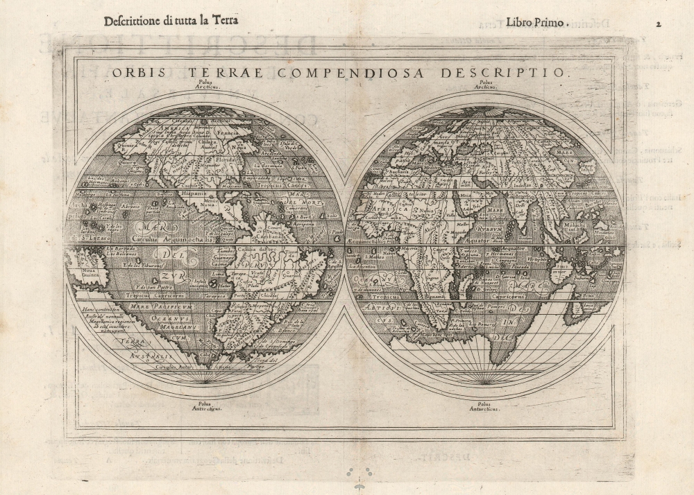
This is Giuseppe Rosaccio’s 1598 double-hemisphere map of the world. Although it was included in Rosaccio's 1598 edition of Ptolemy's Geographia, it is not a Ptolemaic map. Unlike most of the maps in Rosaccio's Ptolemy, which are amended versions of those that appeared in the 1561 Ruscelli Ptolemy, this one is superficially a reduction of the 1587 Mercator world map, but with parallel latitude lines, presenting a more pronounced, elongated South America and Africa - a unique and visually distinctive projection.
Terra Australis or the Speculative Southern Continent
Following Mercator and Ortelius, there is a massive Terra Australis dominating the Southern Hemisphere, extending from Tierra del Fuego nearly to New Guinea. This imaginary continent capping the South Pole was long supposed to exist by European geographers despite the lack of any evidence to support the notion. It was thought, based upon the writings of Aristotle, that the globe was a place of balances and thus geographers presumed the bulk of Eurasia must be counterbalanced by a similar landmass in the Southern Hemisphere. Many explorers in the 16th and 17th centuries sought the Great Southern Continent, including Quiros, Drake, and Cook, but Antarctica itself was not truly discovered until Edward Bransfield and William Smith sighted the Antarctic Peninsula in 1820.Northwest and Northeast Passages
Far to the north an open Arctic Sea passage winds its way around the globe. These are the much sought-after Northwest (to the north of America) and Northeast Passages (over Asia). It was hoped that high-latitude maritime routes or 'passages' would provide quick access to the rich markets of Asia, which offered both an outlet for European silver and furs from the American colonies, as well as produced spices, silks, and other trade goods coveted in Europe. When Mercator included this on his map, no one had successfully navigated such a passage, but many scholars argued that it must exist. Countless explorers lost their lives in search of the apocryphal routes. Today, with the advent of global warming reducing the size of the Polar Ice Cap, a navigable passage has indeed formed. Publication History and Census
This map appeared in both the 1598 and 1599 editions of Rosaccio's Ptolemy, both entitled Geografia di Claudio Tolomeo Alessandrino. Over a century later the plate was reutilized in Lasor a Vareas' 1713 Universus Terrarum Orbis Scriptorum. This late printing included the text 'T.2.pag.284' at the top right of the map, not present here. The separate map is cataloged only once in institutional collections, and the in the 1713 state. According to OCLC Ruscelli's Ptolemy is scarce, with the 1598 appearing in five or six and 1599 eight or nine institutional collections.
Cartographer
Giuseppe Rosaccio (approx. 1530 - 1620) was a Venetian physician, astrologer, and geographer. He was born in the Venetian city of Pordenone, and graduated from the University of Padua having studied philosophy, medicine and law. He moved to seek his fortune in Tricesimo, where he worked as a physician and may have taught literature. His legal education led him to serve as a judge there in civil trials during the period between 1561 and 1575. 1607 found him in Florence in the service of Grand Duke Cosimo II (patron of Galileo). Rosaccio married, and had at least two children: Leonardo - who died on April 30, 1603 - and Luigi (also rendered as Alouisio), who collaborated with his father in his geographical work.
He was a prolific author, producing as many as forty works disseminating new knowledge (to a lay audience, using the Italian vernacular). These were mostly on the topics of astronomy and his primary interest, geography. He ventured afield on an array of subjects, including essays on Islam. He remains best known for his geographical texts, which were popular and republished in multiple editions. These included a 1598 edition of Ptolemy, a 1607 geography of Italy, and his final work - the 1610 Discorso nel quale si tratta brevemente della nobiltà, et eccellenza della Terra rispetto à Cieli, et altri elementi, was dedicated to Cosimo II and contained novel information on the American continent, including Drake and Cavendish' circumnavigations. This work included a map drawn by his son Alouisio. More by this mapmaker...
Source
Rosaccio, G., Geografia di Claudio Tolomeo Alessandrino, (Venice: Sessa) 1598.
Very good condition. Some wormholes not impacting printed image.
Rumsey 11299.034 (1599 ed.). OCLC 1062350694. Shirley 217.