
Rosaccio, Giuseppe

Giuseppe Rosaccio (approx. 1530 - 1620) was a Venetian physician, astrologer, and geographer. He was born in the Venetian city of Pordenone, and graduated from the University of Padua having studied philosophy, medicine and law. He moved to seek his fortune in Tricesimo, where he worked as a physician and may have taught literature. His legal education led him to serve as a judge there in civil trials during the period between 1561 and 1575. 1607 found him in Florence in the service of Grand Duke Cosimo II (patron of Galileo). Rosaccio married, and had at least two children: Leonardo - who died on April 30, 1603 - and Luigi (also rendered as Alouisio), who collaborated with his father in his geographical work.
He was a prolific author, producing as many as forty works disseminating new knowledge (to a lay audience, using the Italian vernacular). These were mostly on the topics of astronomy and his primary interest, geography. He ventured afield on an array of subjects, including essays on Islam. He remains best known for his geographical texts, which were popular and republished in multiple editions. These included a 1598 edition of Ptolemy, a 1607 geography of Italy, and his final work - the 1610 Discorso nel quale si tratta brevemente della nobiltà, et eccellenza della Terra rispetto à Cieli, et altri elementi, was dedicated to Cosimo II and contained novel information on the American continent, including Drake and Cavendish' circumnavigations. This work included a map drawn by his son Alouisio.
He was a prolific author, producing as many as forty works disseminating new knowledge (to a lay audience, using the Italian vernacular). These were mostly on the topics of astronomy and his primary interest, geography. He ventured afield on an array of subjects, including essays on Islam. He remains best known for his geographical texts, which were popular and republished in multiple editions. These included a 1598 edition of Ptolemy, a 1607 geography of Italy, and his final work - the 1610 Discorso nel quale si tratta brevemente della nobiltà, et eccellenza della Terra rispetto à Cieli, et altri elementi, was dedicated to Cosimo II and contained novel information on the American continent, including Drake and Cavendish' circumnavigations. This work included a map drawn by his son Alouisio.
One of the Earliest Double-Hemisphere World Maps, Updated.
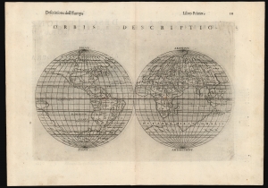
Orbis Descriptio.
$1,400.00
Acquire
- Digital Map Information
- Suitable for large format printing
- Full resolution TIFF file
- ICC color profile embedded
- Delivered instantly via download link
This is a 1598 second-state issue of Girolamo Ruscelli's 1561 map of the world. In its first 1561 state, this is the earliest acquirable double-hemisphere world map, but even this later issue remains one of the earliest acquirable maps to use this format. (more details)
Rare, Venetian Imprint.
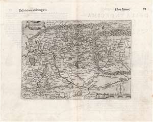
Di Hungaria et Transilvania Tavola novissima Franco for.
$600.00
Acquire
- Digital Map Information
- Suitable for large format printing
- DPI: 600
- File Size: 14.88 MB
- File Type: ZIP / TIFF
- ICC color profile embedded
- Delivered instantly via download link
This is a rare 1597 map of Hungary and Transylvania by the Venetian mapmaker Giacomo Franco. The map is credited as the work of Bernardino Valle, that draftsman's sole known work. It is derived from the cartography of János Zsámboky, probably via the intermediary of Abraham Ortelius. (more details)
Distinctive map based on Mercator.
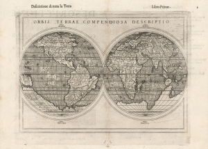
Orbis Terrae Compendiosa Descriptio.
$1,500.00
Acquire
- Digital Map Information
- Suitable for large format printing
- DPI: 600
- File Size: 6.46 MB
- File Type: ZIP / TIFF
- ICC color profile embedded
- Delivered instantly via download link
This is Giuseppe Rosaccio’s 1598 double-hemisphere map of the world. Although it was included in Rosaccio's 1598 edition of Ptolemy's Geographia, it is not a Ptolemaic map. Unlike most of the maps in Rosaccio's Ptolemy, which are amended versions of those that appeared in the 1561 Ruscelli Ptolemy, this one is superficially a reduction of the 1587 Mercator world map, but with parallel latitude lines, presenting a more pronounced, elongated South America and Africa - a unique and visually distinctive projection. (more details)
Scarce Miniature Africa.
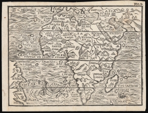
[Untitled map of Africa].
$500.00
Acquire
- Digital Map Information
- Suitable for large format printing
- DPI: 600
- File Size: 6.22 MB
- File Type: ZIP / TIFF
- ICC color profile embedded
- Delivered instantly via download link
This attractive woodcut map of Africa was executed by Giuseppe Moretti for inclusion in the 1688 edition of Giuseppe Rosaccio's Teatro del Mondo. It is an entertaining composition, embellished with a sea monster in the Atlantic and a sailing ship entering the Indian Ocean. The appearance of a woodcut map in this period is itself unusual, especially coming from Italy. Venetian and Roman mapmakers had been working on copperplate well before that technology had passed to Antwerp and Amsterdam. (more details)
Scarce Miniature Black Sea and Lithuania.
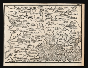
[Untitled map of Eastern Europe].
$400.00
Acquire
- Digital Map Information
- Suitable for large format printing
- DPI: 600
- File Size: 5.34 MB
- File Type: ZIP / TIFF
- ICC color profile embedded
- Delivered instantly via download link
This attractive woodcut map of Lithuania, Ukraine, Bulgaria, Russia, and the Black Sea was executed by Giuseppe Moretti for inclusion in the 1688 edition of Giuseppe Rosaccio's Teatro del Mondo. It is an entertaining composition, embellished with tents indicating Muscovy and Tatary, menacing Lithuania from above the Black Sea. The production of a woodcut map in this period is itself unusual, especially coming from Italy. Venetian and Roman mapmakers had been working on copperplate well before that technology had passed to Antwerp and Amsterdam. (more details)
Scarce Miniature Europe.
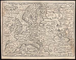
[Untitled map of Europe].
$400.00
Acquire
- Digital Map Information
- Suitable for large format printing
- DPI: 600
- File Size: 5.73 MB
- File Type: ZIP / TIFF
- ICC color profile embedded
- Delivered instantly via download link
This attractive woodcut map of Europe was executed by Giuseppe Moretti for inclusion in the 1688 edition of Giuseppe Rosaccio's Teatro del Mondo. It is an entertaining composition, embellished with tents indicating the nomadic hordes historically menacing Poland and Lithuania from above the Black Sea. The production of a woodcut map in this period is itself unusual, especially coming from Italy. Venetian and Roman mapmakers had been working on copperplate well before that technology had passed to Antwerp and Amsterdam. (more details)
A Scarce Miniature Woodcut of Asia.
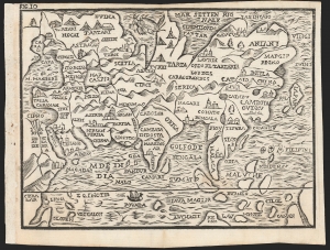
[Untitled map of Asia].
$500.00
Acquire
- Digital Map Information
- Suitable for large format printing
- DPI: 600
- File Size: 5.58 MB
- File Type: ZIP / TIFF
- ICC color profile embedded
- Delivered instantly via download link
This attractive woodcut map of Asia was executed by Giuseppe Moretti for inclusion in the 1688 edition of Giuseppe Rosaccio's long-lived Teatro del Mondo. It is an entertaining composition, embellished with a sea monster in the Northern Ocean, and a sailing ship crossing the Indian Ocean. The appearance of a woodcut map in this period is itself unusual, especially coming from Italy. Venetian and Roman mapmakers had been working on copperplate well before that technology had passed to Antwerp and Amsterdam. (more details)