This item has been sold, but you can get on the Waitlist to be notified if another example becomes available, or purchase a digital scan.
1843 Malte-Brun Map of the World on Mercator's Projection
WorldMercator-maltebrun-1843$75.00

Title
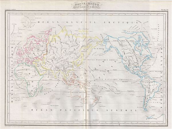
Mappe-monde suivant la projection de Mercator.
1843 (undated) 14 x 18 in (35.56 x 45.72 cm)
1843 (undated) 14 x 18 in (35.56 x 45.72 cm)
Description
This is a fine example of Conrad Malte-Brun's 1843 map of the World on Mercator's Projection. An interesting map of the world issued just as most of the earth's non-polar shore has been explored. Gone are many of the errors of the previous century with the coastlines of the Arctic, the American Northwest, Australia, and New Zealand accurately rendered. Inland though, much remained confused. Vast stretches of unmapped territory and speculative cartography fill central Asia, the western United States, Africa and Australia. Various cities, towns, rivers, lakes, mountains and other topographical details are marked, with relief shown by hachures. Boundaries are color coded according to countries and territories. This map was issued as plate nos. 31 and 32 in Conrad Malte-Brun's 1843 Precis de la Geographie Universelle.
Cartographer
Conrad Malte-Brun (August 12, 1755 - December 14, 1826) was an important late 18th and early 19th century Danish / French cartographer and revolutionary. Conrad was born in Thisted, Denmark. His parents encouraged him to a career in the Church, but he instead enrolled in the University of Copenhagen. In the liberal hall of academia Conrad became an ardent supporter of of the French Revolution and the ideals of a free press. Despite the harsh censorship laws of crown prince Frederick VI, Malte-Brun published numerous pamphlets criticizing the Danish government. He was finally charged with defying censorship laws in 1799 and forced to flee to Sweden and ultimately France. Along with colleague Edme Mentelle, Malte-Brun published his first cartographic work, the Géographie mathématique, physique et politique de toutes les parties du monde (6 vols., published between 1803 and 1807). Conrad went on to found Les Annales des Voyages (in 1807) and Les Annales des Voyages, de la Géographie et de l'Histoire (in 1819). He also founded the Paris Société de Géographie . In time, Conrad Malte-Brun became known as one of the finest French cartographers of his time. His son Victor Adolphe Malte-Brun (1816 - July 13, 1889) followed in his footsteps, republishing many of Conrad's original 18th century maps as well as producing numerous maps of his own. The Malte-Brun firm operated well into the 1880s. More by this mapmaker...
Source
Malte-Brun, Precis de la Geographie Universelle, ou Description de Toutes les Parties du Monde sur un Plan Nouveau, d'après les Grandes Divisions Naturelles du Globe, (Paris) 1843.
Condition
Very good. Minor creasing on original centerfold. Blank on verso.