1901 Pheils Map of the World and its Time Zones
WorldTimeZones-pheils-1901$950.00

Title
Map of the World with U.S. Supplement.
1901 (dated) 18.25 x 13.25 in (46.355 x 33.655 cm)
1901 (dated) 18.25 x 13.25 in (46.355 x 33.655 cm)
Description
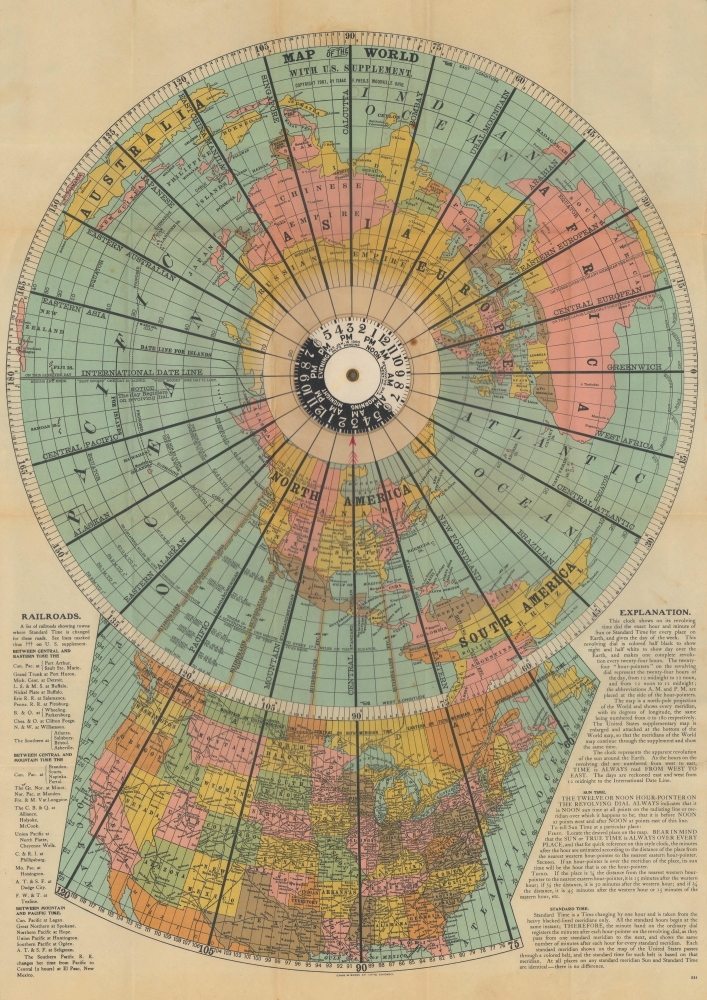
This is a 1901 Isaac F. Pheils map of world time zones on a polar projection. The map captures the significance of embracing standardized time zones in a nation (and world) made increasingly mobile by the rise of the locomotive.
Text to the left and right provides a summary of where railroads switched between time zones and a short explanation of standard time vs. solar time.
A Closer Look
This cartographic curiosity features a volvelle to illustrate time zones. The volvelle is black and white, illustrating day and night. Black lines differentiate twenty-four time zones (at least as they were understood in 1901 - time zones hadn't been completely agreed upon by the international community at that time). An extension below the large polar map details time zones in the United States. In a design flourish, lines extend from the polar projection into the map of the United States, dividing it into four time zones: Eastern, Central, Mountain, and Pacific. Today's time zones vary slightly.Text to the left and right provides a summary of where railroads switched between time zones and a short explanation of standard time vs. solar time.
Standard Time vs. Solar Time
Solar time, the apparent position of the Sun in the sky, varies based on location due to the spherical shape of the Earth. In fact, it differs by four minutes for every degree of longitude. For example, if it is solar noon in London, it is approximately ten minutes before solar noon in Bristol since Bristol is approximately 2.5 degrees west of London. A 'standard time' in the United States was first implemented by railroads on November 18, 1883. Before that date, every railroad ran on its own timetable based on the time at its headquarters or most important terminus. Eighty-five percent of American cities adopted standard time within a year of the country's railroads embracing the system. However, standard time zones were not officially adopted by the United States until March 19, 1918, when Congress passed the Standard Time Act. World time zones were first proposed in 1876, and most countries adopted a standard time zone by 1901.Publication History and Census
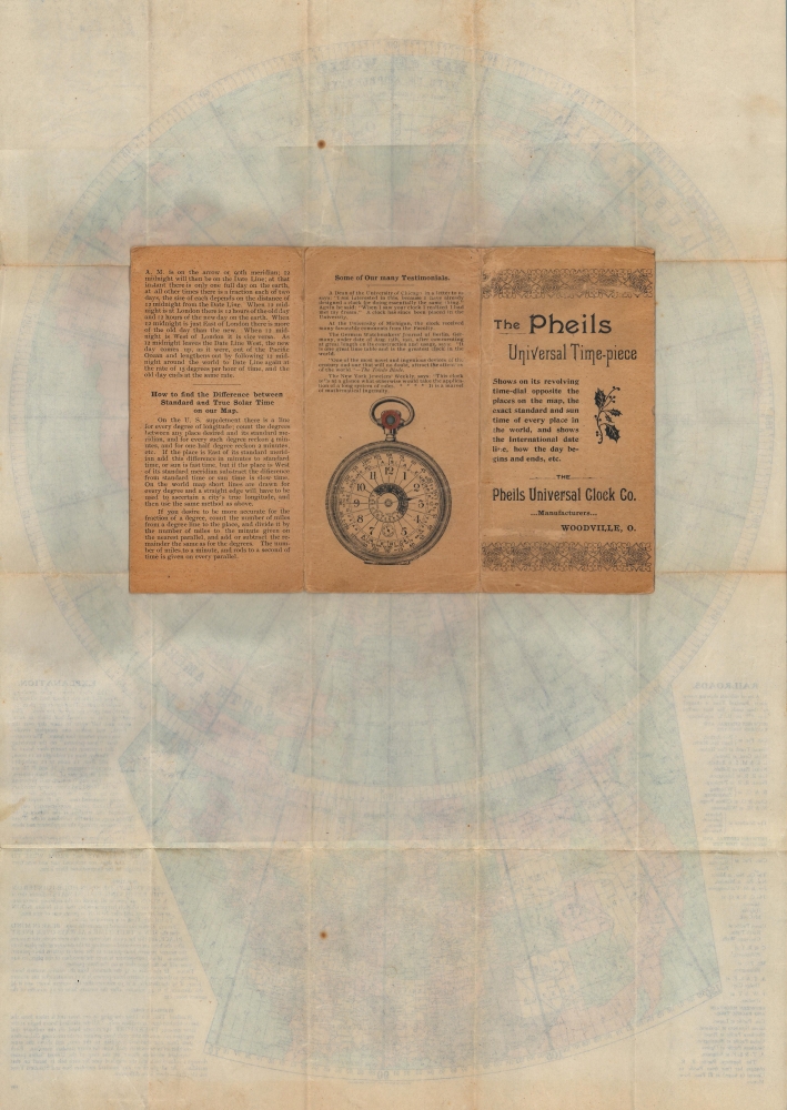
This map was created by Isaac F. Pheils and lithographed by Charles W. Shonk in 1901. This piece does not appear in OCLC, and we note only two instances in the past eighteen years when examples have appeared on the private market. One such example represents the same edition as the presently offered example, but the other differs because of advertisements for Pheils' clocks and watches in the upper left and right corners.CartographerS
Isaac Franklin Pheils (September 21, 1858 - December 18, 1938) was an American inventor and clock maker. Born in Moline, Ohio, Pheils patented a clock/map that made the difference between sun time and standard time easily understandable, known as Pheils Universal Dials or the Pheils Universal Time-piece. Pheils died in Toledo, Ohio. More by this mapmaker...
Charles Welker Shonk (April 6, 1856 - 1931) was an American lithographer. Born in Germantown, Ohio, Shonk opened the Chas. W. Shonk Company in 1886. Originally known as the Shonk Tin Printing Company, The company created tin lithograph signs and trays for numerous companies, including Coca-Cola and Pepsi, along with dozens of breweries. Shonk also printed maps and other lithographs. He sold the company to the American Can Company in 1901 which renamed the business the Shonk Work in 1906. Shonk married Mary Merchant on February 17, 1880, with whom he had two daughters. Learn More...
Condition
Very good. Light wear along original fold lines. Central dial spins with ease. Two small unrepaired fold separations. Attached to original binder.