Digital Image: 1878 Inoue Map of Yokohama, Japan
Yokohama-inouemohei-1878_d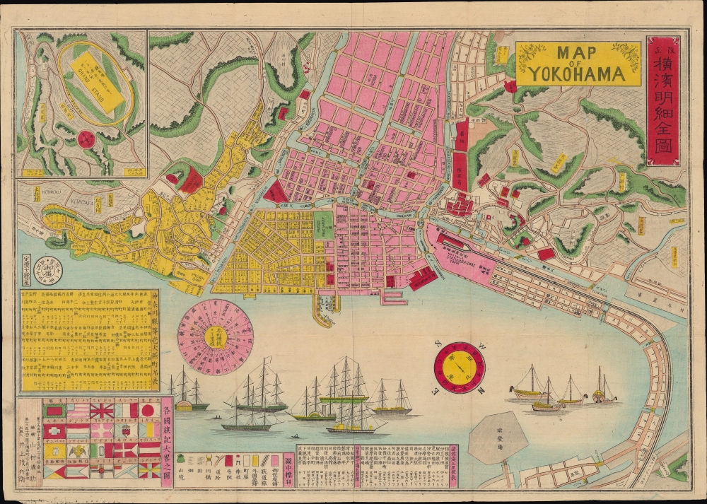
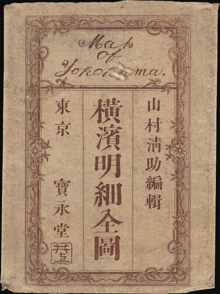


Title
改正橫濱明細全圖 / Map of Yokohama.
1878 (dated) 13.5 x 19.75 in (34.29 x 50.165 cm) 1 : 10150
1878 (dated) 13.5 x 19.75 in (34.29 x 50.165 cm) 1 : 10150
Description
FOR THE ORIGINAL ANTIQUE MAP, WITH HISTORICAL ANALYSIS, CLICK HERE.
Digital Map Information
Geographicus maintains an archive of high-resolution rare map scans. We scan our maps at 300 DPI or higher, with newer images being 600 DPI, (either TIFF or JPEG, depending on when the scan was done) which is most cases in suitable for enlargement and printing.
Delivery
Once you purchase our digital scan service, you will receive a download link via email - usually within seconds. Digital orders are delivered as ZIP files, an industry standard file compression protocol that any computer should be able to unpack. Some of our files are very large, and can take some time to download. Most files are saved into your computer's 'Downloads' folder. All delivery is electronic. No physical product is shipped.
Credit and Scope of Use
You can use your digial image any way you want! Our digital images are unrestricted by copyright and can be used, modified, and published freely. The textual description that accompanies the original antique map is not included in the sale of digital images and remains protected by copyright. That said, we put significant care and effort into scanning and editing these maps, and we’d appreciate a credit when possible. Should you wish to credit us, please use the following credit line:
Courtesy of Geographicus Rare Antique Maps (https://www.geographicus.com).
How Large Can I Print?
In general, at 300 DPI, you should at least be able to double the size of the actual image, more so with our 600 DPI images. So, if the original was 10 x 12 inches, you can print at 20 x 24 inches, without quality loss. If your display requirements can accommodate some loss in image quality, you can make it even larger. That being said, no quality of scan will allow you to blow up at 10 x 12 inch map to wall size without significant quality loss. For more information, it is best consult a printer or reprographics specialist.
Refunds
If the high resolution image you ordered is unavailable, we will fully refund your purchase. Otherwise, digital images scans are a service, not a tangible product, and cannot be returned or refunded once the download link is used.
Cartographer S
Inoue Mohei (井上茂兵衛; 1852 - 1927) was a Japanese cartographer and publisher active in the Meiji period. At the end of the nineteenth century, he served as the head of the Tokyo Jihon Engraving Sales Association (東京地本彫画営業組合), a descendent of the publishers' guilds (地本問屋) that produced ukiyo-e, popular literature, and other essential cultural production of the Tokugawa era. Inoue generally produced nishiki-e (錦絵), an elaborated form of ukiyo-e that were very popular during the Meiji period and which often depicted the introduction or influence of foreign technology, fashion, and ideas in Japan. More by this mapmaker...
Yamamura Seisuke (山村清助; 1847 - 1899), which can also be read Yamamura Kunitoshi or Yamamura Kiyosuke, also known as Utagawa Kunitoshi, was a Japanese woodblock print artist of the Meiji period. As his professional name suggests, he was a member of the esteemed Utagawa school, studying under Utagawa Kunisada I (1786–1865), Utagawa Kunitsugu (1800–1861), and Utagawa Kunisada II (1823-1880). His career overlapped with the opening of Japan to the outside world, and his work falls squarely within the Yokohama-e and kaika-e genres, depicting foreigners and new technologies in Japan, above all in Yokohama. Learn More...
References
OCLC 675574381.