1934 Direccion General de Correos y Telegrafos Map of Yucatan, Mexico
YucatanMexico-transportes-1934$500.00

Title
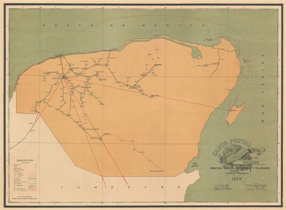
Carta Postal de la Republica Mexicana Estado de Yucatan.
1934 (dated) 24.25 x 33 in (61.595 x 83.82 cm) 1 : 570240
1934 (dated) 24.25 x 33 in (61.595 x 83.82 cm) 1 : 570240
Description
This is a 1934 General Directorate of Post and Telegraphs map of Yucatan, Mexico. The map comprises all of modern-day Yucatan as well as the adjacent modern state of Quintana Roo, including the resort cities of Playa del Carmen, Tulum, Cancun, and the resort islands of Cozumel and Isla Mujeres. The content of the map is nonetheless centered on the spiderweb of roads and tramlines extending outward from Merida - then the center of the henequen trade. Henequen, a type of agave indigenous to the Yucatan peninsula was, for nearly 100 years, the world's finest source of rope-making fiber, making Merida one of the wealthiest cities on Earth. Nonetheless, the emptiness of this map, particularly in the eastern parts, emphasizes the inhospitable nature of most of the peninsula. Around the time this map was issued, faced with competition from other fiber sources, changes in government, and inattention on the part of the hacienda owners, the henequen trade began its fast decline. But, this map is about the mail…
Deciphering Mail Routes of the Yucatan
Mail is delivered in four different ways in Jalisco: on foot, on horseback, by car, or by tram, three of which are depicted by red lines, while trams are illustrated by black lines. Each mode of delivery is marked differently, allowing the viewer to understand how mail is delivered throughout the state. Vertical lines identify the beginning of the route (one vertical line) and the end (two vertical lines). Dashed red lines mark routes that are delivered on foot, while single solid red lines trace those on horseback, and two parallel solid red lines highlight those delivered by car. Routes delivered by tram are marked by thick black lines with vertical dashes. Each route is numerically identified by a four-digit number which appears as the numerator of a fraction, with the all route numbers in Jalisco beginning with the numbers one or five. The frequency of delivery of each route is indicated by the denominator of a given fraction, with 52 marking routes that are delivered once a week, 104 twice weekly, 156 thrice weekly, 312 weekdays, 365 daily, and 730 twice daily. Solid black lines highlight railroads, which deliver mail at varying intervals. The large red lines mark national aviation routes.Publication History and Census
This map was created and published by the General Directorate of Post and Telegraphs of the Transport Office in 1934. This map is scarce on the market.Cartographer
The Dirección General de Correos y Telegrafos (1933 - 1942) was created in 1933 when President Abelardo L. Rodríguez issued a presidential order directing the postal service to take control of telegraph service in Mexico. It was disbanded nine years later when President Manuel Avila Camacho ordered that the postal and telegraph services be separated. More by this mapmaker...
Condition
Very good. Even overall toning. Closed tear extending from right margin 1/3 of the map. Closed margin tear in lower right corner professionally repaired on verso. Exhibits some wormholes and other verso repairs. Blank on verso.