This item has been sold, but you can get on the Waitlist to be notified if another example becomes available, or purchase a digital scan.
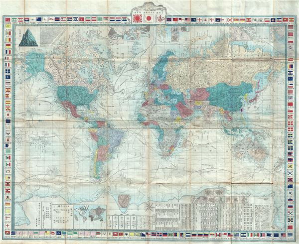
1874 Japanese Shu Oka Map of the World on Mercator Projection
ZoteiYochiKokaizu-world-1875$1,000.00

Title
Zotei yochi kokaizu.
1874 (dated) 28 x 34.5 in (71.12 x 87.63 cm) 1: 35481600
1874 (dated) 28 x 34.5 in (71.12 x 87.63 cm) 1: 35481600
Description
An impressive 1874 (Meiji 7) map of the world by Shu Oka. This finely engraved map covers the entire world on Mercator's Projection. The amp identifies the routes of various explorers throughout with extensive annotation as well as inset city plans, historical and anthropological notes, comparative mountains and rivers charts, and ethnographic maps. The border is composed of the flags of various nations. Cartographically this is an updated and reduction of Seiyo Sato important map of 1862, which itself is derived from Dutch sources admitted to Japan via the open port of Yokohama.
Condition
Very good. Some wear on original fold lies and minor splitting in two or three places.
References
Univ. of California Library, Berkeley, East Asian Library, A27.