1892 Rand McNally Map of Abyssinia (Ethiopia)
Abyssinia-randmcnally-1893$75.00

Title
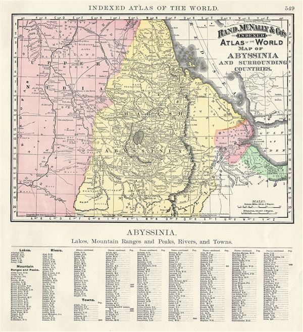
Map of Abyssinia and Surrounding Countries.
1892 (dated) 10 x 13 in (25.4 x 33.02 cm) 1 : 4752000
1892 (dated) 10 x 13 in (25.4 x 33.02 cm) 1 : 4752000
Description
This is a beautiful example of Rand McNally and Company's 1892 map of Abyssinia (Ethiopia) and surrounding countries. It covers from El Mekheir (Berber) to Zooay Lake. This map was made during the last year of the Great Ethiopian Famine, which killed around a third of its population and lasted from 1888 to 1892. This map of Abyssinia and surround countries, printed on half the page unlike most other maps in this atlas, contains a list of divisions, lakes, mountains, rivers and towns in the lower half of the page, on the left of the printed map. Color coded according to regions, the map notes several towns, cities, rivers, mountains, and various other topographical details with relief shown by hachure. This map was issued as plate no. 549 in the 1893 issue of Rand McNally and Company's Indexed Atlas of the World - possibly the finest atlas Rand McNally ever issued.
Cartographer
Rand, McNally and Co. (fl. 1856 - present) is an American publisher of maps, atlases and globes. The company was founded in 1856 when William H. Rand, a native of Quincy, Massachusetts, opened a print shop in Chicago. Rand hired the recent Irish immigrant Andrew McNally to assist in the shop giving him a wage of 9 USD per week. The duo landed several important contracts, including the Tribune's (later renamed the Chicago Tribune) printing operation. In 1872, Rand McNally produced its first map, a railroad guide, using a new cost effective printing technique known as wax process engraving. As Chicago developed as a railway hub, the Rand firm, now incorporated as Rand McNally, began producing a wide array of railroad maps and guides. Over time, the firm expanded into atlases, globes, educational material, and general literature. By embracing the wax engraving process, Rand McNally was able to dominate the map and atlas market, pushing more traditional American lithographic publishers like Colton, Johnson, and Mitchell out of business. Eventually Rand McNally opened an annex office in New York City headed by Caleb S. Hammond, whose name is today synonymous with maps and atlases, and who later started his own map company, C. S. Hammond & Co. Both firms remain in business. More by this mapmaker...
Source
Rand McNally & Co., Rand, McNally & Co's Indexed Atlas of the World, (Chicago) 1893.
Condition
Very good. Text on verso and at bottom of page, left of map.