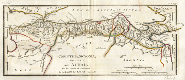
1786 Bocage Map of Corinthia, Sicyonia and Achaia in Ancient Greece
Achaia-white-1793$100.00

Title
Corinthia, Sicyonia Phliasia, and Achaia, for the Travelsof Anacharsis.
1786 6 x 13 in (15.24 x 33.02 cm)
1786 6 x 13 in (15.24 x 33.02 cm)
Description
This lovely little map of Corinthia, Sicyonia and Achaia, in northern Peloponnesus of Ancient Greece, was prepared by M. Barbie de Bocage in 1786 for the 'Travels of Anarcharsis.' Taken from the early D'Anville map.
Cartographer
Jean Denis Barbie du Bocage (1760 - 1825) and his son Jean-Guillaume Barbie du Bocage (1795 - 1848) were French cartographers and cosmographers active in Paris during late 18th and early 19th centuries. The elder Barbie du Bocage, Jean Denis, was trained as a cartographer and engraver in the workshops of mapmaking legend J. B. B. d'Anville. At some point Jean Denis held the post of Royal Librarian of France and it was through is associations with d'Anville that the d'Anville collection of nearly 9000 maps was acquired by French Ministry of Foreign Affairs. The younger Barbie du Bocage, Jean-Guillaume, acquired a position shortly afterwards at the Ministry of Foreign Affairs and, in time, became its head, with the title of Geographe du Ministere des Affaires Etrangeres. More by this mapmaker...
Condition
Fine or Perfect condition.