1860 Dufour Wall Map of France (Set of 4 maps)
AdministrativeFrance-dufour-1860$750.00

Title
Carte Administrative et Physique de la France, Indiquant Les Canaux Les Rivieres Navigable Les Routes, Les Chemins de fer avec leurs Stations.
1860 (dated) 46 x 62 in (116.84 x 157.48 cm) 1 : 1000000
1860 (dated) 46 x 62 in (116.84 x 157.48 cm) 1 : 1000000
Description
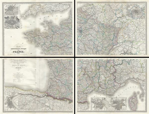
This is an uncommon large format 1860 elephant folio map of France by A. H. Dufour. Essentially four separate sheets, it covers the whole of France including Corsica and parts of Spain, Germany and Switzerland. The first sheet (top left in image) represents northwestern France and includes two insets of Nantes and Rouen. The second sheet (top right) represents northeastern France with an inset of Paris and its environs. The bottom right sheet depicts the southeastern portions of France and includes two insets, one featuring Marseille and the other featuring Lyon. The last sheet on the bottom left is of southwest France. An inset on Bordeaux is included. Throughout, roads, canals, railways, rivers, cities and other topographical features are noted.
This map was prepared by Auguste-Henri Dufour and engraved by Charles Dyonette for publication plate nos. 12, 13, 14 and 15 in Armand Le Chevalier's 1860 edition of Atlas Universel, Physique, Historique et Politique de Geographie Ancienne et Moderne.
This map was prepared by Auguste-Henri Dufour and engraved by Charles Dyonette for publication plate nos. 12, 13, 14 and 15 in Armand Le Chevalier's 1860 edition of Atlas Universel, Physique, Historique et Politique de Geographie Ancienne et Moderne.
CartographerS
Adolphe Hippolyte Dufour (1795 - 1865), also known as Auguste-Henri Dufour, was a Paris based map and atlas publisher active in the middle to late 19th century. Dufour claimed to be a student of another French cartographer, Emile Lapie. He is known to have worked with numerous other French cartographers, publishers, and engravers of the period including Andriveau-Goujon, Charles Dyonnet, and Duvotenay. His corpus includes numerous maps and atlases, the most striking of which is probably his monumental elephant folio Atlas Universel Physique, Historique et Politique Geographie Ancienne et Moderne. Dufour's student and successor was Alexandre Vuillemin. More by this mapmaker...
Charles Dyonnet (fl. c. 1822 - c. 1880) was an extremely active Paris based engraver working in the mid to late 19th century. From his offices at 220 Rue St. Jacques, Paris, Dyonnet engraved numerous maps for many of the most prominent 19th French cartographic publishers including Vuillemin, Dufour, Fremin and Duvotenay. From 1850-1861, he held the coveted position of "Graveur du Dépot de la Marine," and in this position engraved numerous French naval and military maps. Dyonnet had a detail oriented and aesthetically minded hand and is responsible from some of the most beautiful French maps to emerge during the 19th century. Learn More...
Source
Chevalier, A., Atlas Universel, Physique, Historique et Politique de Geographie Ancienne et Moderne, Paris 1860.
The 19th century French cartographer Auguste-Henri Dufour began publishing the dramatic elephant folio Atlas Universel, also occasionally titled Grand Atlas Universal, around 1855. Several editions appeared between its initial publication in the 1850s and a final run c. 1870. The 1863 and 1864 editions in particular are highly desirable among collectors because the United States and North America maps illustrate the proposed, but unrealized, state of Corona (roughly modern day Utah). The atlas contained roughly 40 maps, most of which were engraved by Louis Antoine (the maps) and Deletre (typography) under the supervision of Charles Dyonnet, official engraver of the Depot de la Marine. The Atlas Universal was published in Paris and edited by the firm of 'Paulin et le Chevalier,' 60 Rue Richelieu.
Condition
Very good. Set of 4 maps. Minor wear along original fold lines. Minor spotting at places.
References
Rumsey 5020.019, 5020.018, 5020.017, 5020.016, 5020.015.