This item has been sold, but you can get on the Waitlist to be notified if another example becomes available, or purchase a digital scan.
1842 Allen Case Map of Afghanistan issued for the First Anglo-Afghan War
Afghanistan-allen-1842$1,500.00


Title
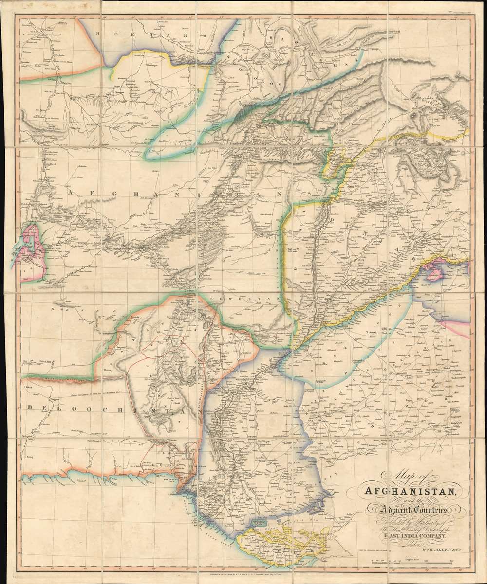
Map of Afghanistan and the Adjacent Countries Published by the Authority of the Hon.ble Court of Directors of the East India Company.
1842 (dated) 30.75 x 25 in (78.105 x 63.5 cm) 1 : 2112000
1842 (dated) 30.75 x 25 in (78.105 x 63.5 cm) 1 : 2112000
Description
This is an 1842 Allen map of Afghanistan and its surrounds, showing the theatre of the First Anglo-Afghan War: the first major conflict of ‘The Great Game’ for British control of India. It was printed just four months after the disastrous Retreat from Kabul. Not only are the passes between Kabul and Peshawar shown in detail but the infamous 'Khyber Pass' is labeled clearly. (surpassing other contemporaneous maps of the area ) that it seems clear that the map reflects the best British understanding of Afghanistan’s geography at the time of the conflict.
Scope of the Map
The map extends from the Gulf of Oman and the Gulf of Kutch northwards to the Emirate of Bukhara, and Badakhshan: it reaches from the endorheic basin of Lake Hamoon in eastern Iran and reaches 'Little Tibet' In the Himalayas, Kashmir, and Lahore. The whole of the map is detailed, but the Indus River Valley and the area between that river and the Hindu Kush are shown with particular granularity. Many cities and the roads connecting them are clearly marked, with hand color delineating the borders between the provinces.The Exile of Dost Muhammad
The Badakhshan region (here spelled Badakshan) commands the north-central part of the map. It was significant in that following the 1839 occupation of Afghanistan by British it became the home-in-exile of Afghanistan's Amir Dost Muhammad Khan, primarily the city of Kunduz. When Badakhshan was unable to assist Dost Muhammad against the British, he moved on the Emirate of Bukhara, also shown on the map. Afghanistan and Emirate of Bukhara would struggle for Balkh and Badakhshan with Afghanistan succeeding.The Theater of War
The geographical spread of what the British refer to as The Disaster in Afghanistan can be found here. All the major cities where actions occurred are shown, with the roads connecting them well detailed: Quetta, Kandahar, Ghazni, Qalat, Kabul and Jalalabad all are shown along with the neighboring villages, passes, and roads. Though the scope of this map is larger than the contemporaneous SDUK maps of Afghanistan, the detail is far sharper and undoubtedly reflects details that were derived from the military action taking place in 1839 and 1840.The Great Game - the struggle for Afghanistan
From 1830 until 1895, a political and diplomatic confrontation, known as 'The Great Game', existed between the British Empire and the Russian Empire over Afghanistan and other territories in Central and Southern Asia. 'The Great Game', as it is known, was ignited due to Russian fears that Britain was making commercial and military inroads in Central Asia, while Britain mutually feared Russia adding 'the jewel in the crown' (India) to its vast empire in Asia. Several wars were fought, including the First Anglo-Afghan War in 1838, the First Anglo-Sikh War in 1845, the Second Anglo-Sikh War in 1848, and the Second Anglo-Afghan War in 1878, along with the Russian annexations of Khiva, Bukhara, and Kokand. Per historians, the Great Game ended on September 10, 1895 with the signing of the Pamir Boundary Commission protocols, which defined the border between Afghanistan and the Russian Empire.Publication History and Census
This map is rare, having been published separately to supplement James Atkinson's 1842The Expedition into Affghanistan. We find only seven examples of this 1842 map listed in OCLC, and two separate examples of an 1844 edition. It appears that this second edition was sometimes included in W. H. Allen's A Gazetteer of the Countries Adjacent to India on the North-West although we do not find a digitized example with the map presentCartographerS
William Houghton Allen (April 14, 1788 - January 1855) was a bookseller and publisher in London, England. He was born in New Sleaford, Lincolnshire, England. Nothing is known of his early education, but he was admitted to the London Company of Stationers as a bookseller in 1817. Shortly afterwards, in 1818, he partnered with others to form 'Black, Kingsbury, Parbury and Allen'. This would evolve into Kingsbury, Parbury, and Allen (William Houghton Allen, Thomas Kingsbury, Charles Parbury) in 1822, and again into Parbury, Allen, and Co. in 1827. In 1835, he struck out on his or, partnering with his sons James Pearce Allen(1818 - 1878) and William Ferneley Allen (1816 - 1877) as 'W. H. Allen and Company'. As 'W. H. Allen, the firm established close ties with the British East India Company, who had offices nearby, also on Leadenhall Street. The firm later moved to 12 Waterloo Place. After Allen's death, the firm went through numerous acquisitions and mergers with the name 'W.H. Allen' persevering until 1991, when it was subsumed into Virgin Publishing. More by this mapmaker...
John Walker (1787 - April 19, 1873) was a British map seller, engraver, lithographer, hydrographer, geographer, draughtsman, and publisher active in London during the 19th century. Walker published both nautical charts and geographical maps. His nautical work is particularly distinguished as he was an official hydrographer for the British East India Company, a position, incidentally, also held by his father of the same name. Walker's maps, mostly published after 1827, were primarily produced with his brothers Charles Walker and Alexander Walker under the imprint J. and C. Walker. Among their joint projects are more than 200 maps for the influential Society for the Diffusion of Useful Knowledge Atlas (SDUK). In addition they published numerous charts for James Horsburgh and the British Admiralty Hydrographic Office, including Belcher's important map of Hong Kong and Carless' exploratory map of Karachi. The J. and C. Walker firm continued to publish after both Walkers died in the 1870s. Learn More...
Condition
Excellent condition. Dissected and mounted on linen as issued. Original embossed boards removed but present.
References
OCLC 221934686.