1749 d'Anville Wall Map of Africa (foundational 18th century map of Africa)
Africa-anville-1749-2$2,500.00
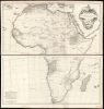


Title
Afrique Publiée sous les Auspices de Monseigneur le Duc D'Orléans Prémier Prince du Sang.
1749 (dated) 40 x 39 in (101.6 x 99.06 cm) 1 : 9500000
1749 (dated) 40 x 39 in (101.6 x 99.06 cm) 1 : 9500000
Description
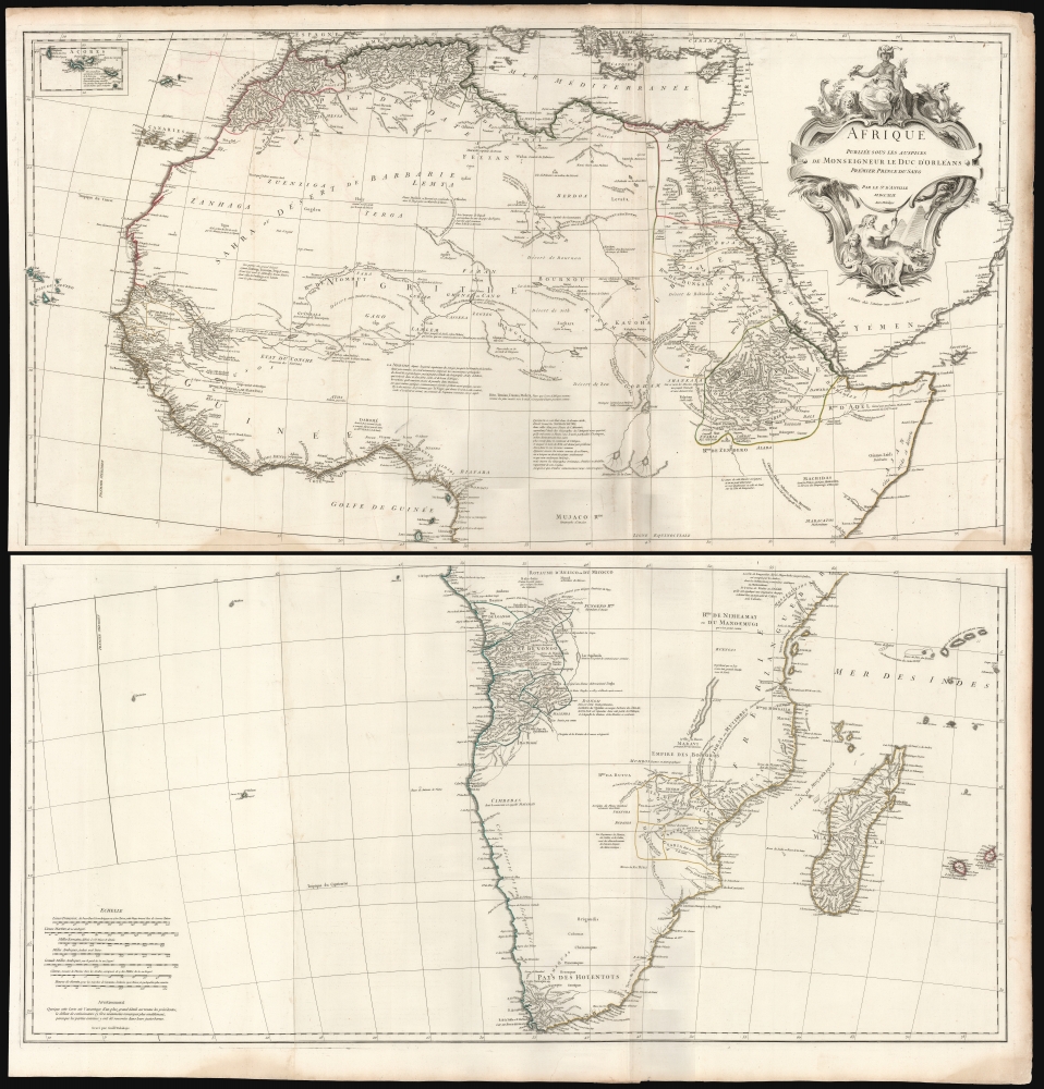
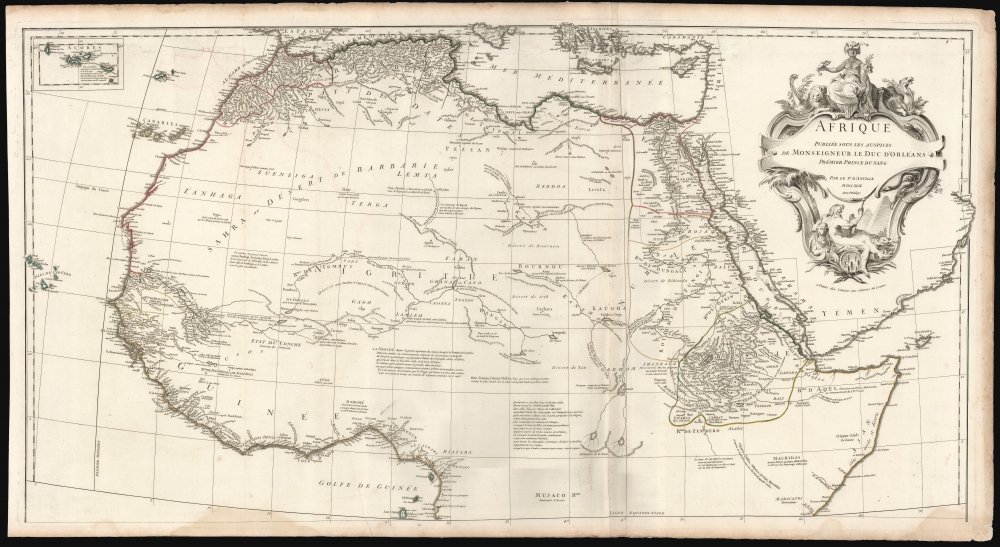
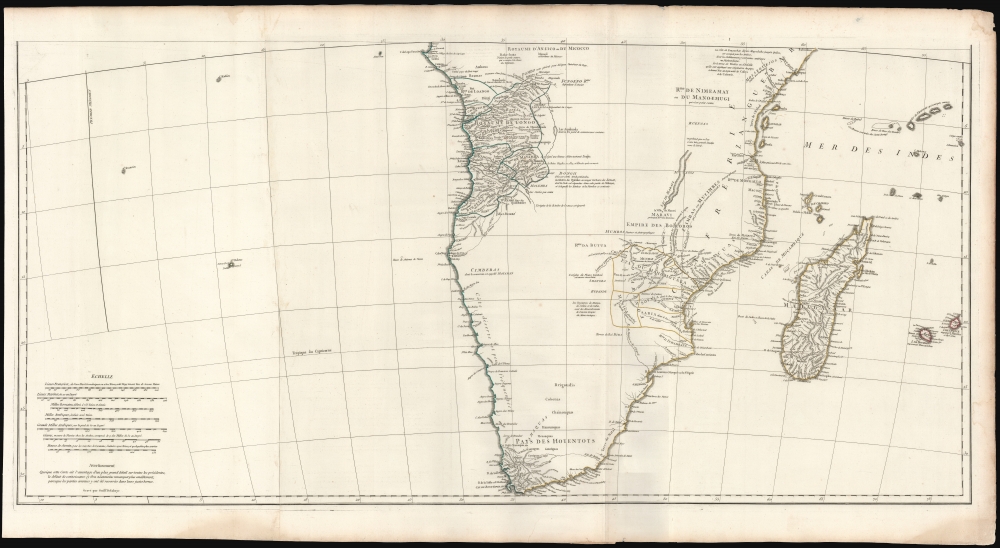
This is Jean-Baptiste Bourguignon d’Anville's 1749 map of Africa, one of the largest and most influential maps of the continent to appear in the 18th century.
A Closer Look
D'Anville's map covers Africa in full, from the Mediterranean to the Cape of Good Hope and from the Cape Verde Islands to Madagascar. Anville was a careful cartographer known for his scientific approach to mapmaking, and nowhere is this more evident than in this grand, innovative map. Following the trajectory set by Guillaume de L'Isle half a century earlier, D'Anville takes significant steps forward in addressing the confusions inherent in mapping this vast - though mostly, in the mid-17th century, unexplored - continent.A Closer Look
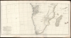
D'Anville's map presents state-of-the-art cartography for many of Africa's coastal kingdoms, and while he does not eliminate many of the erroneous depictions of the interior, he downplays them. For example, although he includes the imaginary 'Mountains of Kong' and Ptolemy's 'Mountains of the Moon', these features are presented much less boldly than on earlier maps, indicating D'Anville's uncertainty. Vast areas are left blank to indicate European ignorance of the interior. Nevertheless, there is still a wealth of detail derived from Arab, colonial, missionary, and exploratory penetrations of the continent. The best-mapped parts are found on the Mediterranean Coast, Morocco, Senegambia, the Congo, South Africa, the Kingdom of Monomatapa, Abyssinia, and Egypt. Morocco, Egypt, and the southern Mediterranean Coast (Barbary) were well known to Europeans since antiquity, and D'Anville's accurate mapping of these regions reflects continual exchange. Further south, the colonial enclaves along the Niger River (Senegal and Gambia), the Congo River, and South Africa reflect considerable detail associated with European penetration by traders and missionaries. The Portuguese explored the land of Monomatapa around the Zambezi River early in the 16th century in hopes that the legendary gold mines supposedly found there would counterbalance the wealth flowing into Spain from the New World. Unfortunately, these mines were mostly tapped out by the 15th century.Lake Malawi
A proto-Lake Nyassa or Lake Malawi, here identified as Maravi, appears in an extended embryonic state that suggests accuracy, although the lake had not been conclusively discovered by Europeans, and would not be until Portuguese trader Candido Jose da Costa Cardoso stumbled upon it in 1849 - one hundred years following D'Anville's presentation here. D'Anville's inclusion of Lake Malawi is most likely a prescient interpretation of indigenous reports brought to Europe by 17th-century Portuguese traders. Its form would be followed by subsequent cartographers well into the mid-19th century when the explorations of John Hanning Speke, David Livingstone, Richard Francis Burton, and others at last produced a semi-detailed study of Africa's interior.Publication History and Census
D'Anville published this map in 1749 to update his earlier 1727 map of Africa. As with most of D'Anville's maps, this was not produced for a specific atlas but instead was sold individually to be tipped into composite atlases or preserved as a case or wall map by the purchaser. The present example was printed on four sheets and joined in pairs; the folds and binding strips indicate that this example was bound at one time. The map is well represented in institutional collections.Cartographer
Jean Baptiste Bourguignon d'Anville (1697 - 1782) was perhaps the most important and prolific cartographer of the 18th century. D'Anville's passion for cartography manifested during his school years when he amused himself by composing maps for Latin texts. There is a preserved manuscript dating to 1712, Graecia Vetus, which may be his earliest surviving map - he was only 15 when he drew it. He would retain an interest in the cartography of antiquity throughout his long career and published numerous atlases to focusing on the ancient world. At twenty-two D'Anville, sponsored by the Duke of Orleans, was appointed Geographer to the King of France. As both a cartographer and a geographer, he instituted a reform in the general practice of cartography. Unlike most period cartographers, D'Anville did not rely exclusively on earlier maps to inform his work, rather he based his maps on intense study and research. His maps were thus the most accurate and comprehensive of his period - truly the first modern maps. Thomas Basset and Philip Porter write: "It was because of D'Anville's resolve to depict only those features which could be proven to be true that his maps are often said to represent a scientific reformation in cartography." (The Journal of African History, Vol. 32, No. 3 (1991), pp. 367-413). In 1754, when D'Anville turned 57 and had reached the height of his career, he was elected to the Academie des Inscriptions. Later, at 76, following the death of Philippe Buache, D'Anville was appointed to both of the coveted positions Buache held: Premier Geographe du Roi, and Adjoint-Geographer of the Academie des Sciences. During his long career D'Anville published some 211 maps as well as 78 treatises on geography. D'Anville's vast reference library, consisting of over 9000 volumes, was acquired by the French government in 1779 and became the basis of the Depot Geographique - though D'Anville retained physical possession his death in 1782. Remarkably almost all of D'Anville's maps were produced by his own hand. His published maps, most of which were engraved by Guillaume de la Haye, are known to be near exact reproductions of D'Anville' manuscripts. The borders as well as the decorative cartouche work present on many of his maps were produced by his brother Hubert-Francois Bourguignon Gravelot. The work of D'Anville thus marked a transitional point in the history of cartography and opened the way to the maps of English cartographers Cary, Thomson and Pinkerton in the early 19th century. More by this mapmaker...
Source
Anville, J. B. B., Atlas Generale, (Paris) 1749.
Condition
Very good. Four sheets joined in pairs, as bound. Minor water stain to lower right, just entering printed area, else excellent with original outline color and a bold, even strike. Measurements given for full map if joined.
References
OCLC 1190863076. Rumsey, 2603.008,2603.009, 2603.010 . Tooley R. V., Maps of Africa p. 3-4. Phillips (Atlases) 571, 572, 599. National Maritime Museum, 200.