This item has been sold, but you can get on the Waitlist to be notified if another example becomes available, or purchase a digital scan.
1834 Burr Map of Africa
Africa-burr-1835$100.00

Title
Africa.
1834 (dated) 11.5 x 13.5 in (29.21 x 34.29 cm) 1 : 31680000
1834 (dated) 11.5 x 13.5 in (29.21 x 34.29 cm) 1 : 31680000
Description
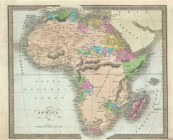
An interesting example of the 1834 first edition map of Africa by David H. Burr. This is an early 19th century and historically important representation of the continent of Africa. Nineteenth century mapmakers were particularly challenged by the difficult task of deciphering Africa. Despite a fairly constant flow of information about the continent dating to the middle ages, much of the interior remained speculative at best. Burr chooses to leave much of the interior blank and instead focuses known areas, or more precisely, areas perceived to be known. These include Mediterranean North Africa, Egypt, Abyssinia, the western Niger valley, the Congo, South Africa, and the lands of Mozambique and (Zimbabwe).
Each of these regions have their own unique history of European contact. Egypt, along the Nile, had been well mapped even in antiquity. The same is true of Christian Abyssinia which, through regular contact with the Coptic mother church in Egypt and Portuguese missionaries, was well known, if mostly unexplored by Europeans. The tale of European incursion and occupation of South Africa could easily encompass volumes and explains Burr’s sophisticated mapping of this region. The Niger Valley and the Congo had been simultaneously exploited and explored by Portugal and later Belgium since the 1300s.
Mocaranga or Monomotapa, opposite the island of Madagascar, was a major stopping point on the Portuguese trade routes to India. Curiously this region has also been associated with King Solomon's Mines and Biblical legends of the Land of Ophir. Bradford identifies Monomotapa, which by this time had long fallen into decline. He also identifies several of its constituent states including Manica, Sabia, Botanga and Sofala.
The remaining parts of the map are frequently quite vague. North of the Mocaranga region we can find the embryonic mapping of Lake Maravi, a long narrow lake oriented on a north-south axis. The lake labeled here, but shown as a single line, most likely represents Lake Malawi or Lake Tanganyika, or both. The Ptolemaic Mountains of the Moon are drawn stretching across the central part of the continent with the suggestions that they are the source of several branches of the Nile.
At the time this map was made, the slave trade, thriving since the 5th century was rapidly diminishing due to decreased demand for slaves in the New World, the British outlawing of slavery in 1808, and subsequent diplomatic efforts including treaties with over 50 African rulers outlawing the practice. Many African economies adapted by shifting to the export of mineral and agricultural resources, which led to the European scramble for territory, occupying most of the continent by the end of the 19th century. Europe's colonial interests in Africa haphazardly carved up the continent into unnatural territories, often forcing historic enemies into close proximity and leading to social problems that remain to this day.
According to Ristow, although Burr is credited on the title page, he left this atlas incomplete. He was appointed as topographer to the U.S. Post Office, and of the sixty-three maps finally included in this atlas, only completed eight. The rest of the maps were then completed by Illman and Pilbrow in Burr's style. This map was published by D. S. Stone in Burr’s 1835New Universal Atlas.
CartographerS
David Hugh Burr (August 18, 1803 - December 25, 1875) of one of the first and most important truly American cartographers and map publishers. Burr was born in Bridgeport Connecticut in August of 1803. In 1822 Burr moved to Kingsboro, New York to study law. A year and a half later he was admitted to the New York Bar association. Burr must have questioned his choice of careers because shortly after being admitted to the Bar, he joined the New York State Militia. Though largely untrained in the art of surveying, Burr was assigned to work under Surveyor General of New York, Simeon De Witt, to survey several New York Roadways. Seeing a window of opportunity, Burr was able to negotiate with the governor of New York at the time, De Witt Clinton, to obtain copies of other New York survey work in order to compile a map and Atlas of the state of New York. Recognizing the need for quality survey work of its territory, the government of New York heartily endorsed and financed Burr's efforts. The resulting 1829 Atlas of the State of New York was the second atlas of an individual U.S. state and one of the most important state atlases ever produced. Burr went on to issue other maps both of New York and of the United States in general. In cooperation with publishing firm of Illman & Pillbrow, he produced an important New Universal Atlas and, with J.H. Colton, several very important maps of New York City. In recognition of this work, Burr was appointed both "Topographer to the Post office" and "Geographer to the House of Representatives of the United States". Later, in 1855, Burr was assigned to the newly created position of Surveyor General to the State of Utah. Burr retired from the position and from cartographic work in general in 1857 when light of some of his financial misdeeds and frauds came to light. He was accused of submitting false expense reports and underpaying employees, among other indiscretions. More by this mapmaker...
Thomas Illman (fl. c. 1824 – 1858) was an English engraver active in New York City during the early 19th century. Illman was born in England and attended Trinity College in Oxford where he attained a degree in theology. Despite initial religious fervor, he soon became an atheist. Professionally he turned to engraving to support his artistic tendencies. In London he mastered the engraver's art. His first paying work as an artist was illustrating for Thomas Carlyle's Confessions of an English Opium Eater. He relocated to New York City in 1828, almost immediately partnering with Edward Pilbrow to found the firm Illman and Pilbrow. Illman and Pillbrow were almost immediately hired by David H. Burr to engrave maps for his Universal Atlas, which he began working on in that year. When Burr took a position as topographer and cartographer for the United States Post Office, he ceded all remaining work on the Atlas to Illman and Pilbrow. In addition to his atlas work, Illman privately pursued his own art as well as engraved portraits and landscapes. He was admired as a skilled line, stipple, and mezzotint engraver. At some point he may have relocated to Philadelphia. His sons, H. Illman and G. Illman followed in his footsteps founding Illman Sons in 1845 Learn More...
Source
Burr, David H., A New Universal Atlas; Comprising Separate Maps of All the Principal Empires, Kingdoms & States Throughout the World: and forming a distinct Atlas of the United States, (New York: D. S. Stone) 1835 (First Edition).
Burr's New Universal Atlas was first published in 1835. It is one of the first great American commercial atlases and one of the most important to appear before the Civil War. Burr was most likely initially inspired to publish a 'universal atlas' in pursuit a more general audience by the success of his 1829 Atlas of New York State. He began work on the Universal Atlas sometime around 1830. By 1832 he had copyrighted eight new maps for the work. Around this time he accepted a position as topographer and cartographer for the United States Postal Department and was thus unable to finish the atlas personally. Instead, while retaining editing rights and overall ownership, Burr passed much of the production work to his engravers Thomas Illman and Edward Pillbrow. The first edition of the atlas was completed in 1835 and published by D. S. Stone of New York. A second edition, published by William Hall, appeared in the following year, 1836. Both editions featured 63 maps, the first part of the book being dedicated to world maps and the second part to the Americas, particularly the United States. Some of the 1836 editions feature outline rather than the distinctive full color common in the first edition. The plates for the atlas were later sold to Jeremiah Greenleaf who expanded the atlas to 65 maps and issued editions in 1840, 1842, and 1848.
Condition
Very good. Minor foxing. Original platemark visible. Lower margin trimmed with imprint cut off, not affecting map borders. Suitable for framing.
References
Rumsey 4628.027. Philips (Atlases) 771.