This item has been sold, but you can get on the Waitlist to be notified if another example becomes available, or purchase a digital scan.
1762 Janvier Map of Africa
Africa-janvier-1762$200.00

Title
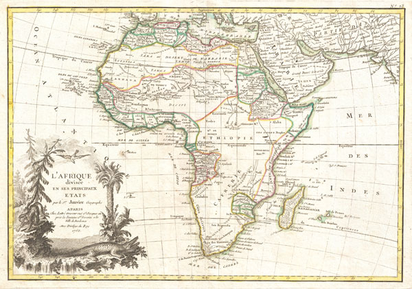
L'Afrique divisee en ses Principaux Etats.
1762 (dated) 12 x 17.5 in (30.48 x 44.45 cm)
1762 (dated) 12 x 17.5 in (30.48 x 44.45 cm)
Description
A beautiful example of Jean Janvier's 1762 map of Africa. Covers the entire continent as well as the Island of Madagascar and adjacent parts of Persia and Arabia. Divided into various regions with color-coding according to the colonial power active in the region. Course of the Nile follows the Ptolemaic two lake theory. Shows the Mountains of the Moon just south of the Ptolemaic lakes. In southeastern Africa there is a long lake speculatively drawn in and labeled L. Maram, but which most likely represents an embryonic Lake Tanganyika. Much of central Africa is blank, suggesting the profound lack of knowledge of the interior. Nonetheless, several major river systems, including the Niger, the Congo, and parts of the Nile to show indications of active exploration. Names numerous African kingdoms and tribal groups throughout, though admittedly few correspond with the groups we know today. In the lower left hand quadrant there is an elaborate decorative title cartouche exhibiting a Nile crocodile, a leopard, vegetation, a bird and a waterfall - possibly one of the Nile cataracts. Drawn by J. Janvier for issue as plate no. 23 in Jean Lattre's 1775 issue of the Atlas Moderne.
CartographerS
Jean Denis Janvier (fl. 1746 - 1776), sometime also known as 'Robert', was a Paris based cartographer active in the mid to late 18th century. Janvier signed his maps Signor Janvier. By the late 18th century, Janvier was awarded the title of 'Geographe Avec Privilege du Roi' and this designation appears on many of his later maps. Janvier worked with many of the most prominent French, English and Italian map publishers of his day, including Longchamps, Faden, Lattre, Bonne, Santini, Zannoni, Delamarche, and Desnos. More by this mapmaker...
Jean Lattré (170x - 178x) was a Paris based bookseller, engraver, globe maker, calligrapher, and map publisher active in the mid to late 18th century. Lattré published a large corpus of maps, globes, and atlases in conjunction with a number of other important French cartographic figures, including Janvier, Zannoni, Bonne and Delamarche. He is also known to have worked with other European cartographers such as William Faden of London and the Italian cartographer Santini. Map piracy and copyright violations were common in 18th century France. Paris court records indicate that Lattré brought charges against several other period map publishers, including fellow Frenchman Desnos and the Italian map engraver Zannoni, both of whom he accused of copying his work. Lattré likes trained his wife Madame Lattré (né Vérard), as an engraver, as a late 18th century trade card promotes the world of 'Lattré et son Epouse.' Lattré's offices and bookshop were located at 20 rue St. Jaques, Paris, France. Later in life he relocated to Bordeaux. Learn More...
Source
Lattre, Jean, Atlas Moderne ou Collection de Cartes sur Toutes les Parties du Globe Terrestre, c. 1775.
Condition
Very good condition. Original centerfold exhibits minor toning. Blank on verso.
References
Rumsey 2612.061. Phillips (Atlases) 664. National Maritime Museum, 215.