This item has been sold, but you can get on the Waitlist to be notified if another example becomes available, or purchase a digital scan.
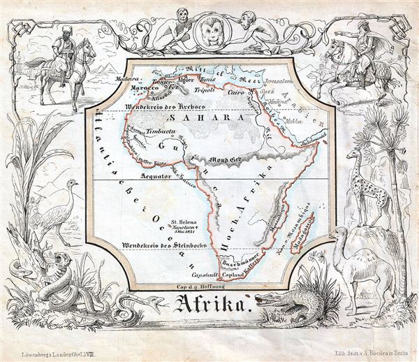
1846 Lowenberg Whimsical Map of Africa
Africa-lowenberg-1846$100.00

Title
Afrika.
1846 (undated) 5.5 x 6.5 in (13.97 x 16.51 cm)
1846 (undated) 5.5 x 6.5 in (13.97 x 16.51 cm)
Description
A delightfully whimsical 1846 map of Africa, from a German kinderatlas or children's atlas. The map covers the entire continent from the Mediterranean Sea to Cape Town. Also includes the island of Madagascar. The whole is surrounded by a wide border featuring charming vignettes meant to illustrate the peoples and cultures of the region. These include a tiger being strangled by an anaconda, a camel, a crocodile, a giraffe, and equestrian figures. The map is accompanied by its adjacent page, which includes a poetic history of Africa in German gothic type. The wonderful and rare map was drawn by Anst. V A. Boeden of Berlin for inclusion as plate no. XVIII in the 1846 issue of Julius Loewenberg's Geographische Landerfibel.
Cartographer
Julius Loewenberg (1800 - December 12, 1893) was a German Jewish printer, geographer, and author active in Berlin during the middle part of the 19th century. Loewenberg was born in the Duchy of Posen. He attended Yeshiva in Kleczewo (Poland) and graduated to the Protestant Gymnasium of Thorn before moving on to study Christian theology and geography at the Universtiy of Berlin. His works include various atlases, histories, and several translations of the works of Alexander von Humboldt, with whom he was apparently close. Loewenberg died in a Jewish retirement home in Berlin. More by this mapmaker...
Source
Lowenberg, J., Geographische Landerfibel, (Berlin: Stern & C.) 1846.
Condition
Very good. Even overall toning. Blank on verso.