This item has been sold, but you can get on the Waitlist to be notified if another example becomes available, or purchase a digital scan.
1836 Malte-Brun Map of Africa
Africa-maltebrun-1837$50.00

Title
Afrique.
1836 (dated) 13.5 x 17 in (34.29 x 43.18 cm)
1836 (dated) 13.5 x 17 in (34.29 x 43.18 cm)
Description
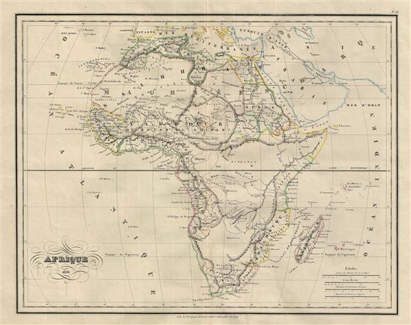
This is a fascinating example of Conrad Malte-Brun's 1836 map of Africa. The map covers the entire continent from the Mediterranean Sea to Cape Colony and from the Atlantic Ocean to Madagascar and the Seychelles Islands in the Indian Ocean. An interesting map issued just as most of the earth's non-Polar shores were finally explored. Inland though, much remained unknown. The present map exhibits various speculations regarding the unexplored interior of Africa. The course of the White Nile shown here is speculative at a best, neither Mt. Kenya nor Mt. Kilimanjaro are shown, the apocryphal Mountains of the Moon stretch across the continent, and what may be some sort of Proto-Lake Victoria is identified here as Lac Ouiffua.
At the time this map was made, the slave trade, thriving since the 5th century was rapidly diminishing due to decreased demand for slaves in the New World, the British outlawing of slavery in 1808, and subsequent diplomatic efforts including treaties with over 50 African rulers outlawing the practice. Many African economies adapted by shifting to the export of mineral and agricultural resources, which led to the european scramble for territory, occupying most of the continent by the end of the 19th century. europe's colonial interests in Africa haphazardly carved up the continent into unnatural territories, often forcing historic enemies into close proximity and leading to social problems that remain to this day.
Various important rivers, islands, lakes, mountains, cities and other topographical details are noted with relief shown by hachures. The map is color coded according to countries and territories. This map was issued as plate no. 56 in Conrad Malte-Brun's 1837 Atlas Complet du Precis de la Geographie Universelle.
Cartographer
Conrad Malte-Brun (August 12, 1755 - December 14, 1826) was an important late 18th and early 19th century Danish / French cartographer and revolutionary. Conrad was born in Thisted, Denmark. His parents encouraged him to a career in the Church, but he instead enrolled in the University of Copenhagen. In the liberal hall of academia Conrad became an ardent supporter of of the French Revolution and the ideals of a free press. Despite the harsh censorship laws of crown prince Frederick VI, Malte-Brun published numerous pamphlets criticizing the Danish government. He was finally charged with defying censorship laws in 1799 and forced to flee to Sweden and ultimately France. Along with colleague Edme Mentelle, Malte-Brun published his first cartographic work, the Géographie mathématique, physique et politique de toutes les parties du monde (6 vols., published between 1803 and 1807). Conrad went on to found Les Annales des Voyages (in 1807) and Les Annales des Voyages, de la Géographie et de l'Histoire (in 1819). He also founded the Paris Société de Géographie . In time, Conrad Malte-Brun became known as one of the finest French cartographers of his time. His son Victor Adolphe Malte-Brun (1816 - July 13, 1889) followed in his footsteps, republishing many of Conrad's original 18th century maps as well as producing numerous maps of his own. The Malte-Brun firm operated well into the 1880s. More by this mapmaker...
Source
Malte-Brun, Atlas Complet du Precis de la Geographie Universelle, (Paris) 1837.
Condition
Very good. Original centerfold. Blank on verso.
References
Rumsey 0458.057 (1834 edition). Phillips (Atlases) 6079.