This item has been sold, but you can get on the Waitlist to be notified if another example becomes available, or purchase a digital scan.
1576 Heinrich Petri Ptolemaic Map of Africa
Africa-petriptolemy-1576$150.00

Title
Untitled Map of Africa
1576 (undated) 5.25 x 6 in (13.335 x 15.24 cm)
1576 (undated) 5.25 x 6 in (13.335 x 15.24 cm)
Description
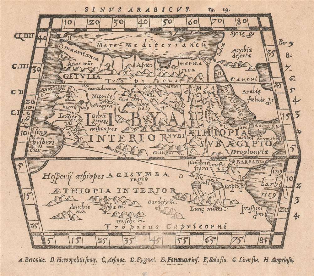
An attractively-executed map 16th-century woodcut map of Africa. The most general of the Ptolemaic maps of Africa, extending far enough south to fully show Ptolemy’s mythical source of the Nile River in the ‘Mountains of the Moon.’ The continent extends further still, expanding to east and west as it exits the map: Ptolemy’s conception of the world was that the Indian Ocean was an inland sea, and that Africa’s landmass continued to expand both eastward and westward to connect to China. As this 16th century woodcut was a historical work depicting 2nd century geographical knowledge, this error has been retained.
It was printed in 1576 by Heinrich Petri to illustrate his edition of Pomponius Mela’s De orbis situ, libri III and Iulius Solinus’ Polyhistor, two seminal . As neither Mela (first century CE) nor Solinus (third century CE) initially included maps in their works, Petri had to rely on another ancient source of maps for the book: Claudius Ptolemy (fl. 83-161 CE,) whose treatise on geography laid the foundation for all modern cartography, and whose work had already been reproduced in many editions in the 16th century, some published by Petri himself. Ptolemy’s general map of Africa would have been the natural choice for illustrating the situation of the Persian Gulf (the section heading at the top of the page, Sinus Arabicus, suggests that this was the purpose of the map in this context.)
It was printed in 1576 by Heinrich Petri to illustrate his edition of Pomponius Mela’s De orbis situ, libri III and Iulius Solinus’ Polyhistor, two seminal . As neither Mela (first century CE) nor Solinus (third century CE) initially included maps in their works, Petri had to rely on another ancient source of maps for the book: Claudius Ptolemy (fl. 83-161 CE,) whose treatise on geography laid the foundation for all modern cartography, and whose work had already been reproduced in many editions in the 16th century, some published by Petri himself. Ptolemy’s general map of Africa would have been the natural choice for illustrating the situation of the Persian Gulf (the section heading at the top of the page, Sinus Arabicus, suggests that this was the purpose of the map in this context.)
CartographerS
Heinrich Petri (1508 - 1579) and his son Sebastian Henric Petri (1545 – 1627) were printers based in Basel, Switzerland. Heinrich was the son of the printer Adam Petri and Anna Selber. After Adam died in 1527, Anna married the humanist and geographer Sebastian Münster - one of Adam's collaborators. Sebastian contracted his stepson, Henricus Petri (Petrus), to print editions of his wildly popular Cosmographia. Later Petri, brought his son, Sebastian Henric Petri, into the family business. Their firm was known as the Officina Henricpetrina. In addition to the Cosmographia, they also published a number of other seminal works including the 1566 second edition of Nicolaus Copernicus's De Revolutionibus Orbium Coelestium and Georg Joachim Rheticus's Narratio. More by this mapmaker...
Claudius Ptolemy (83 - 161 AD) is considered to be the father of cartography. A native of Alexandria living at the height of the Roman Empire, Ptolemy was renowned as a student of Astronomy and Geography. His work as an astronomer, as published in his Almagest, held considerable influence over western thought until Isaac Newton. His cartographic influence remains to this day. Ptolemy was the first to introduce projection techniques and to publish an atlas, the Geographiae. Ptolemy based his geographical and historical information on the "Geographiae" of Strabo, the cartographic materials assembled by Marinus of Tyre, and contemporary accounts provided by the many traders and navigators passing through Alexandria. Ptolemy's Geographiae was a groundbreaking achievement far in advance of any known pre-existent cartography, not for any accuracy in its data, but in his method. His projection of a conic portion of the globe on a grid, and his meticulous tabulation of the known cities and geographical features of his world, allowed scholars for the first time to produce a mathematical model of the world's surface. In this, Ptolemy's work provided the foundation for all mapmaking to follow. His errors in the estimation of the size of the globe (more than twenty percent too small) resulted in Columbus's fateful expedition to India in 1492.
Ptolemy's text was lost to Western Europe in the middle ages, but survived in the Arab world and was passed along to the Greek world. Although the original text almost certainly did not include maps, the instructions contained in the text of Ptolemy's Geographiae allowed the execution of such maps. When vellum and paper books became available, manuscript examples of Ptolemy began to include maps. The earliest known manuscript Geographias survive from the fourteenth century; of Ptolemies that have come down to us today are based upon the manuscript editions produced in the mid 15th century by Donnus Nicolaus Germanus, who provided the basis for all but one of the printed fifteenth century editions of the work. Learn More...
Source
Petri, H. [De chorographia] Pomponii Melæ De orbis situ, libri III. Et C. Iulii Solini, Polyhistor: quorum ille descriptionem singularum orbis terreni partium atque regionum: Hic uero præter eadem, quæ ubiq[ue] memorabilia sint loca, animantia, ... compendiose enarrat. Authores ut politissimi, ita geographiæ studiosis utilissimi, in quorum gratiam Mela scholiis, uterq[ue] uerò tabulis elegantibus illustratus est, præfixo indice sufficienti
Condition
Very good. Lightly toned. Blank verso.
References
JCB 13178.