1658 Visscher Map of Africa
Africa-visscher-1658-2$1,000.00

Title
Africae Accurata Tabula ex officina Nic. Visscher.
1658 (undated) 16.75 x 21.25 in (42.545 x 53.975 cm) 1 : 22000000
1658 (undated) 16.75 x 21.25 in (42.545 x 53.975 cm) 1 : 22000000
Description
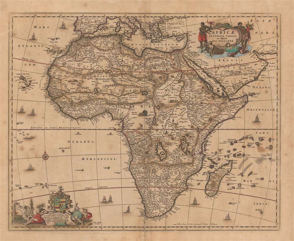
This is a c. 1677 second state example of Nicolas Visscher's 1658 map of Africa. It is beautifully decorated, with lively cartouches (see below), eleven ships, a brace of flying fish, and a whale. Visscher's superb engraving affords a superabundance of detail, which reveals a contrast between a strong understanding of Africa's coastal regions and a profound ignorance of the interior.
The Nile
The map's depiction of the course of the Nile dates to Claudius Ptolemy (who imagined the great river emanating from two massive lakes in south-central Africa, fed from springs in the imaginary Lunae Montes, the Mountains of the Moon.)The Niger
The Niger River is shown as well - springing from a Niger Lacus in the general vicinity of the Congo, flowing north and then westward to empty near the actual location of the Gambia River. (The Niger, whose entire course was not understood by Europeans until well into the 19th century, actually begins in West Africa well south of The Gambia, and then flows eastwards, emptying into the Gulf of Guinea.) Visscher was certainly not alone in these misconceptions: Betz notes that Visscher follows the model of Blaeu's wall map of the continent, updating it to show the 1652 Dutch settlement at the Cape of Good Hope, as well as other Dutch place names such as Tafel Bay, Tafel berg (Table Bay and Table Mountain, respectively) and Robben Island.Title Cartouche
The map's title and author's name appear in a shell-like cartouche in the upper right. It is supported by two angels, one blowing a horn. These also support African figures who flank the cartouche, one holding a cornucopia (a symbol of fertility) and the other a scorpion (one of several animal symbols for Africa in Dutch iconography.)Dedicatory Cartouche
On the lower left, the map is embellished with a superb dedicatory cartouche. It depicts a scene in which Neptune reclines, giving ear to a partially-robed, wild-haired woman leaning against the cartouche with a saucy expression, brandishing a fish. Another woman, listening alongside Neptune, appears eager to hear. A man, strategically positioned behind the callipygian speaker and sporting an unmistakable smirk, seems less interested in the fish story and more interested in the view. In the background, two mer-figures spout water from cornucopias - a sign that they represent rivers, very likely the Nile and the Niger. This gently ribald scene stands in apparent stark contrast to the dedicatee, one Dr. Gerardo Schaep (1694 - 1666), a staunchly conservative Calvinist diplomat and politician. He was a well-respected Amsterdam regent, having been elected mayor eleven times. He also served as the Republic's envoy extraordinary to Denmark and Sweden. His patronage would have been invaluable, hence his appearance on several Visscher maps.Visscher's Calling Card
The fish being waved about in the cartouche likely has less to do with Dr. Schaep and more to do with the mapmaker. Visscher's name translates literally to 'Fisher,' and thus, fishermen and fish alike were a calling card and adorn many of the mapmaking family's works.Publication History and Census
This is the second state of this map, bearing Visscher's privilege to publish, awarded in 1677. The map appeared in Nicolas Visscher II's atlases through the early 18th century. The map appears on the market with some regularity and is well represented in institutional collections.Cartographer
Claes Jansz Visscher (1587 - 1652) established the Visscher family publishing firm, which were prominent Dutch map publishers for nearly a century. The Visscher cartographic story beings with Claes Jansz Visscher who established the firm in Amsterdam near the offices of Pieter van den Keer and Jadocus Hondius. Many hypothesize that Visscher may have been one of Hondius's pupils and, under examination, this seems logical. The first Visscher maps appear around 1620 and include numerous individual maps as well as an atlas compiled of maps by various cartographers including Visscher himself. Upon the death of Claes, the firm fell into the hands of his son Nicholas Visscher I (1618 - 1679), who in 1677 received a privilege to publish from the States of Holland and West Friesland. The firm would in turn be passed on to his son, Nicholas Visscher II (1649 - 1702). Visscher II applied for his own privilege, receiving it in 1682. Most of the maps bearing the Visscher imprint were produced by these two men. Many Visscher maps also bear the imprint Piscator (a Latinized version of Visscher) and often feature the image of an elderly fisherman - an allusion to the family name. Upon the death of Nicholas Visscher II, the business was carried on by the widowed Elizabeth Verseyl Visscher (16?? - 1726). After her death, the firm and all of its plates was liquidated to Peter Schenk. More by this mapmaker...
Source
Visscher, Nicolas II, Atlas Minor, (Amsterdam) c. 1677.
Condition
Good. Old color oxidized in places, necessitating minor fill as well as as backing with archival tissue to offer overall stabilization. Even overall toning. Some transference.
References
OCLC 19717449. Rumsey 11755.119. Betz 87.2. Norwich 55 state 2.