1823 Manuscript Map of Africa
Africa-wyld-1823$500.00

Title
Africa.
1823 (undated) 14.5 x 17.5 in (36.83 x 44.45 cm)
1823 (undated) 14.5 x 17.5 in (36.83 x 44.45 cm)
Description
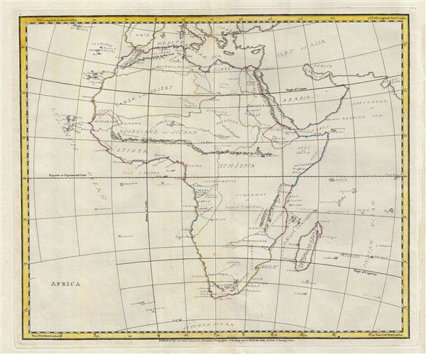
An unusual and beautiful semi-manuscript map of the Africa dating to 1823. The printed portions of this map follow the cartography of James Wyld and include the basic outlines of the countries, latitude and longitude lines, the Tropic of Capricorn, the equator, and the Meridian of London. The remainder of the map, including all textual labels and color work, had been completed in manuscript, that is to say, hand drawn. Wyld most likely produced this map intentionally without labels for use as a classroom workbook by which children could learn geography by filling in the blanks.
The manuscript geographical data and detail throughout is altogether outstanding. The work is completed in a fine hand adept at decorative text and the rendering of rivers and mountains. The geography follows the conventions of the period. Africa is transected by a large apocryphal mountain range identified as the Mountains of Kong in the west and the Mountains of the Moon in the east. Both ranges were speculated as possible sources for Africa's great river systems, the Niger and the Nile, respectively. Although the cartographer makes little attempt to map the interior in serious detail, reflecting the general lack of european knowledge of the region, some areas are represented more thoroughly than others. These include the Senegambia, egypt Nubia and Abyssinia, the Congo, South Africa, and the Lands of Monomotapa and Mozambique. Lake Malawi is illustrated in an embryonic but largely accurate form. Throughout various tribal nations are noted.
An altogether unique and wonderful one of a kind find.
Cartographer
Wyld (1823 - 1893) was a British publishing firm active throughout the 19th century. It was operated by James Wyld I (1790 - 1836) and his son James Wyld II (November 20, 1812 - 1887) were the principles of an English mapmaking dynasty active in London during much of the 19th century. The elder Wyld was a map publisher under William Faden (1749 - 1836) and did considerable work on the Ordinance Survey. On Faden's retirement in 1823, Wyld took over Faden's workshop, acquiring many of his plates. Wyld's work can often be distinguished from his son's maps through his imprint, which he signed as 'Successor to Faden'. Following in his father's footsteps, the younger Wyld joined the Royal Geographical Society in 1830 at the tender age of 18. When his father died in 1836, James Wyld II was prepared to fully take over and expand his father's considerable cartographic enterprise. Like his father and Faden, Wyld II held the title of official Geographer to the Crown, in this case, Queen Victoria. In 1852, he moved operations from William Faden's old office at Charing Cross East (1837 - 1852) to a new, larger space at 475 Strand. Wyld II also chose to remove Faden's name from all of his updated map plates. Wyld II continued to update and republish both his father's work and the work of William Faden well into the late 1880s. One of Wyld's most eccentric and notable achievements is his 1851 construction of a globe 19 meters (60 feet) in diameter in the heart of Leicester Square, London. In the 1840s, Wyld also embarked upon a political career, being elected to parliament in 1847 and again in 1857. He died in 1887 following a prolific and distinguished career. After Wyld II's death, the family business was briefly taken over by James John Cooper Wyld (1844 - 1907), his son, who ran it from 1887 to 1893 before selling the business to Edward Stanford. All three Wylds are notable for producing, in addition to their atlas maps, short-run maps expounding upon important historical events - illustrating history as it was happening - among them are maps related to the California Gold Rush, the New South Wales Gold Rush, the Scramble for Africa, the Oregon Question, and more. More by this mapmaker...
Condition
Very Good. Partial manuscript. Original centerfold. Platemark visible. Wide margins.