This item has been sold, but you can get on the Waitlist to be notified if another example becomes available, or purchase a digital scan.
1879 Charmetant Map of Eastern Africa, Tanzania and Environs
AfriqueEquatoriale-charmetant-1879$175.00

Title
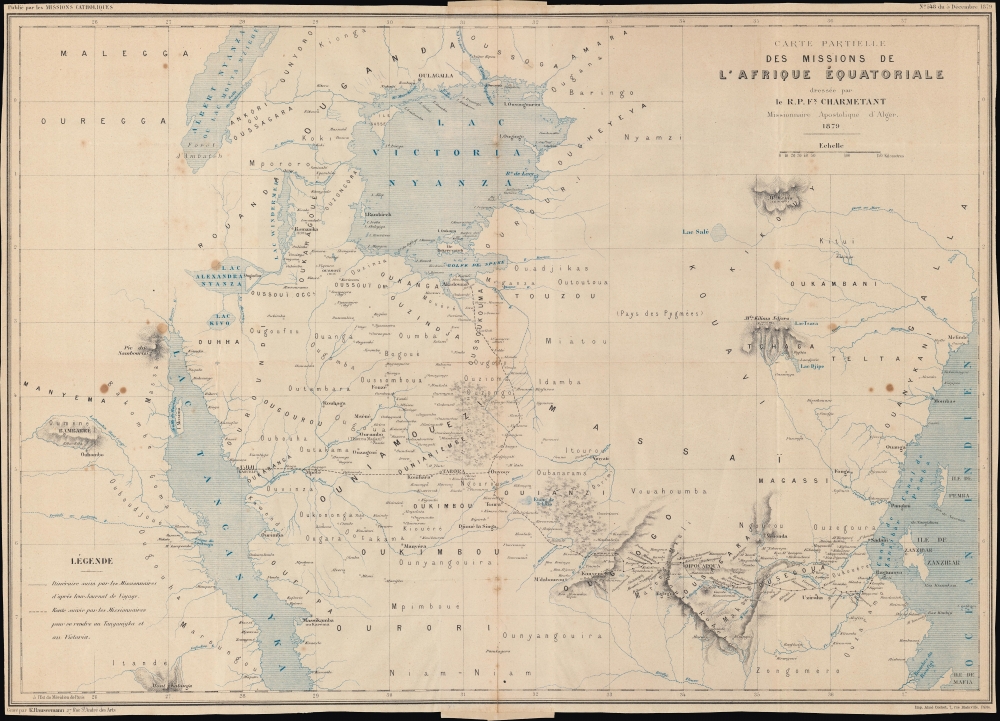
Carte partielle des Missions de l'Afrique Équatoriale.
1879 (dated) 16.5 x 22.75 in (41.91 x 57.785 cm) 1 : 2250000
1879 (dated) 16.5 x 22.75 in (41.91 x 57.785 cm) 1 : 2250000
Description
An interesting map of 'Equatorial Africa' by the French missionary Félix Charmetant, taking in parts or the entirety of the present-day countries of Tanzania, Kenya, Uganda, Rwanda, Burundi, and the Democratic Republic of the Congo. Charmetant traces the routes of recent French missionary expeditions (which he helped plan) and provides an overview of regional geography, hitherto little known to Europeans.
A Closer Look
Covering a large portion of eastern Africa, the map takes in Lake Victoria and large portions of Lake Albert and Lake Tanganyika. The routes of two French expeditions from Bagamoyo, opposite Zanzibar, to Lakes Victoria and Tanganyika are traced. Mountains, terrain, settlements, and waterways are noted. Local ethnic groups and kingdoms are also recorded. However, portions of the interior not traversed by the missionaries remained terra incognita, such as the 'Pays de Pygmées' east of Lake Victoria.In Lieu of an Empire
In the late 19th century, France underwent two concurrent but seemingly incompatible processes, secularization and anticlericalism at home, and a reliance on Catholic missions abroad. With enthusiasm for imperial adventures waning and unable to compete with the British on commercial terms, the French instead promoted the mission civilisatrice. French schools, hospitals, and charitable works were established to spread French influence without the high cost of invading and occupying foreign lands. However, the group that showed the most interest in this mission was the same one being expelled from French schools, hospitals, and public life in France itself; that is, the Catholic Church. As odd as it seems, this arrangement benefitted both parties, and assuaged the extremely bitter feelings between church and state at the turn of the 20th century. In addition to their educational and charitable works, in the East African context, like early British explorers such as David Livingstone and Henry Morton Stanley, the Pères Blancs sought to counteract the long-established slave trade.Publication History and Census
This map was prepared by the R. P. Félix Charmetant, a French missionary stationed at the time in Zanzibar, was engraved by Rémy Hausermann, and was printed by Imprimerie Aimé Cochet. It appeared in the December 5, 1879, issue of Les Missions Catholiques (No. 548). It is independently cataloged in the OCLC at the Université Laval, the Bibliothèque nationale de France, and the Staatsbibliothek zu Berlin, and it is also held by the Bibliothèques municipales de Chambéry.CartographerS
Félix Charmetant (June 20, 1844 - July 21, 1921) was a French Catholic missionary belonging to the Missionnaires d'Afrique, better known as the Pères blancs. He began his apostolic work in Algeria before being posted to Zanzibar in 1878 to prepare the first French missionary efforts in central Africa. However, illness forced him to return to France and then to North Africa again. In 1885 he became the director of l'Œuvre d'Orient, an association which primarily focused on education in the lands of the 'Eastern Christians'. Charmetant held this position until his death, and under his tutelage the organization built many French-speaking schools in the late / former Ottoman empire. He was also a vocal advocate for Armenians, who suffered terribly in the last years of Ottoman rule. In 1882, he was made a Chevalier in the French Legion of Honor. More by this mapmaker...
Rémy Hausermann (1843 - 1933) was a French map engraver who, among other roles, was the main engraver for the Missions Catholiques de Lyon, allowing him to introduce the geography of areas previously little known or unknown to a European audience. Little is known about his early life and training, but by 1879 he was the Vice President of the Congrès des Sciences géographiques. He was well-known and well-regarded in geographical study circles in the late 19th century, writing school textbooks on the subject and receiving accolades at the 1878 exposition universelle in Paris. Learn More...
Condition
Very good. Binding strip attached at centerfold where previously bound into a publication. Wear and toning along original centerfold. Light soiling.
References
OCLC 1131394781. Bibliothèques municipales de Chambéry, CAR AFR B 000.091.