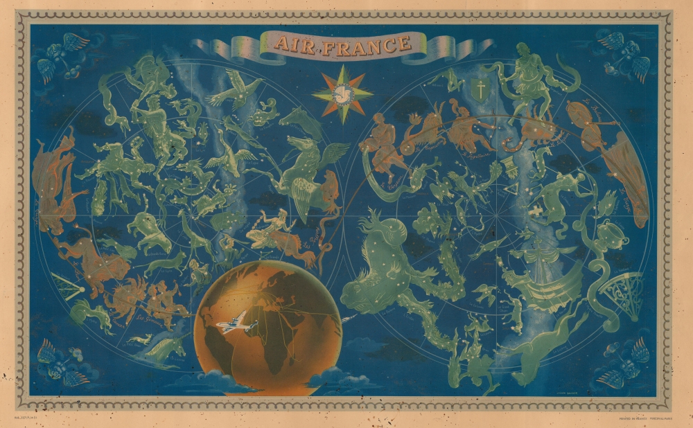
1951 Lucien Boucher Air France Double Hemisphere Celestial Map of the Constellations
AirFranceCelestial-boucher-1951$700.00

Title
Air France.
1951 (dated) 14 x 22.75 in (35.56 x 57.785 cm)
1951 (dated) 14 x 22.75 in (35.56 x 57.785 cm)
Description
The finest of Lucien Boucher's iconic maps drawn for Air France, this is a 1951 medium-format edition of his beautiful double hemisphere pictorial map of the constellations. Boucher's work for Air France is considered an embodiment of the golden age of air travel.
A Closer Look
Boucher illustrates the constellations as seen from the northern and southern hemispheres. The constellations of the Zodiac are highlighted in gold and orange. Taurus is missing from this group, as it is obscured by the Earth. Rendered in tones of burnt orange, Air France's route network appears over the Earth. Wind heads decorate each corner. Here the airplane is master not just of the sky, but the whole universe, connecting the passenger not merely to earthly destinations, but to the heavenly spheres themselves.Chromolithography
Chromolithography is a color lithographic technique developed in the mid-19th century. The process involved using multiple lithographic stones, one for each color, to yield a rich composite effect. Oftentimes, the process would start with a black basecoat upon which subsequent colors were layered. Some chromolithographs used 30 or more separate lithographic stones to achieve the desired product. Chromolithograph color could also be effectively blended for even more dramatic results. The process became extremely popular in the late 19th and early 20th centuries, when it emerged as the dominate method of color printing. The vivid color chromolithography produced made it exceptionally effective for advertising and propaganda imagery.Publication History
This map was printed for Air France by Perceval of Paris. This chart is dated via a reference number in the lower left, 557/P./4-51, suggesting a 1951 publication date. This is the smaller format of the two editions of this wonderful work that we are aware of, with editions of the larger format edition published in 1950 and 1953, based on inferences from reference numbers that appear on those examples.Cartographer
Lucien Boucher (1889 - 1971) was French cartoonist, artist, writer, and illustrator. Boucher was born in Chartres in 1889 and graduated from the École de Céramique de Sèvres. His work as a cartoonist appeared in the humorous weekly Le Rire. Starting in the 1920s he produced numerous pictorial posters inspired by the commercial promise of surrealism. Among them were a series of surrealistic planispheric and celestial maps drawn to illustrate the transportation networks of Air France. More by this mapmaker...
Condition
Average. Even overall toning. Soiling.