This item has been sold, but you can get on the Waitlist to be notified if another example becomes available, or purchase a digital scan.
1828 Finley Map of Alabama
Alabama-finley-1828$175.00

Title
Alabama.
1828 (undated) 11.75 x 8.75 in (29.845 x 22.225 cm) 1 : 2027520
1828 (undated) 11.75 x 8.75 in (29.845 x 22.225 cm) 1 : 2027520
Description
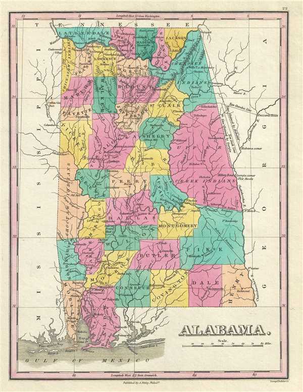
This is an 1828 Anthony Finley map of Alabama. The map depicts the state from Tennessee to the Gulf of Mexico and from Mississippi to Georgia in Finley's classic minimalist style. Rivers, roads, canals, and some topographical features are illustrated. Numerous cities and towns are labeled, including Mobile and Tuscaloosa. Counties are easily differentiated as they are labeled and shaded various colors.
Finley's map of Alabama is particularly interesting and important due to its portrayal of the rapidly changing American Indian situation in the eastern part of the state. In 1828 a substantial part of northeastern Alabama was territory assigned to the Upper Creek and Cherokee nations. Finley's map details the contracting borders to this territory noting the 'Indian Boundary,' the 'New Indian Boundary,' and the 'New Cherokee Line.' Numerous American Indian villages and missionary stations within the Upper Creek and Cherokee territories are noted. Just four years after this map was made the Creek and Cherokee would forcibly relocated westward in the infamous 'Trail of Tears.'
This map is also of interest as it details a territorial dispute between Alabama and Georgia. Early surveying errors attributed the same territory to both states. Shortly before this map was made, the territorial dispute was settled on behalf of Georgia.
This map was engraved by Young and Delleker for the 1828 edition of Anthony Finley's General Atlas.
Cartographer
Anthony Finley (August 25, 1784 - June 9, 1836) was an American book and map publisher based in Philadelphia, Pennsylvania. Finley was born in Philadelphia in 1784. He opened a bookshop and publishing house at the Northeast corner of Fourth and Chestnut Street, Philadelphia in 1809. His earliest known catalog, listing botanical, medical and other scientific works, appeared in 1811. His first maps, engraved for Daniel Edward Clarke’s Travels in Various Countries of Europe, Asia, and Africa also appear in 1811. His first atlas, the Atlas Classica, was published in 1818. He soon thereafter published the more significant A New American Atlas and the New General Atlas…, both going through several editions from 1824 to 1834. Although most of Finley's cartographic material was borrowed from European sources, his atlases were much admired and favorably reviewed. In addition to his work as a printer, Finley ran unsuccessfully on the 1818 Democratic ticket for Philadelphia Common Council. He was a founding officer of the Philadelphia Apprentices’ Library, and a member of both the American Sunday-School Union and the Franklin Institute. He was also an ardent supporter of the American Colonization Society, an organization dedication to returning free people of color to Africa - which led to the founding of Liberia. Much of his wealth was dedicated to supporting this cause. Finley was active as a publisher until his 1836 death, apparently of a 'lingering illness.' Shortly thereafter advertisements began appearing for his map business and plates, most of which were acquired by Samuel Augustus Mitchell. More by this mapmaker...
Source
Finley, Anthony, A New General Atlas, Comprising a Complete Set of Maps, representing the Grand Divisions of the Globe, Together with the several Empires, Kingdoms and States in the World; Compiled from the Best Authorities, and corrected by the Most Recent Discoveries, Philadelphia, 1828.
Condition
Very good. Blank on verso.
References
Rumsey 0285.022 (1831 edition) Phillips (Atlases) 4314, 760, 752, 6045. Mason, Sara E., A List of Nineteenth Century Maps of the State of Alabama, 15.