This item has been sold, but you can get on the Waitlist to be notified if another example becomes available, or purchase a digital scan.
1841 Public Survey Map of the State of Alabama
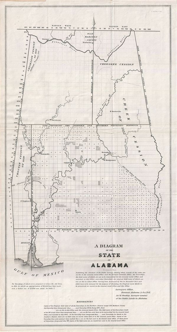
Alabama-publicsurvey-1841$100.00

Title
A Diagram of the State of Alabama.
1841 (dated) 23 x 12 in (58.42 x 30.48 cm)
1841 (dated) 23 x 12 in (58.42 x 30.48 cm)
Description
This is a fine example of the 1841 public survey map of the Alabama, representing the work of the Alabama Land Survey as of October 1841. The map covers the entire state of Alabama from Old Madison County to the Gulf of Mexico and includes the state boundary line between Mississippi and Alabama in the west and Georgia and Alabama in the east. Following shortly on the events associated with the Trail of Tears and the Indian Removal Act in the late 1830s, this map identifies the seized American Indian lands, referring to them as the Cherokee Cession, the Choctaw Cession of 1830, the Chickasaw Cession of 1833 and the Creek Cession on 1832. Various rivers and cities are also identified, including Florence, Huntsville, Sparta, Wetumka, among others. This map was created under the supervision of James H. Weakley, Surveyor General of the Public Lands in Alabama on October 25, 1841. It is noteworthy that these maps commonly appear in very poor condition due to low production quality, yet the present example is near pristine. If you are considering adding this significant map to your collection, this is the one you want.
Cartographer
The General Land Office (1812 - 1946) was an independent agency charged with the administration and sale of public lands of the western territories of the United States under the Preemption Act of 1841 and the Homestead Act of 1862. During a time of frenetic energy and rapid westward expansion, the Land Office oversaw the surveying, platting, mapping and eventually the sale of much of the Western United States and Florida. The structural layout of the western United States that we see today, and many of their district and county divisions, are direct result of the early surveying work of the General Land Office. More importantly, as a branch of the Federal Government in Washington D.C. and the only agency able to legally sell and administer public lands in the western territories of the United States, the General Land Office played a pivotal role in consolidating power away from the original states and into the hands of the centralized federal government. The General Land Office was absorbed into the Department of Interior in 1849 and in 1946 merged with the United States Grazing Service to become the Bureau of Land Management. Today the Bureau of Land Management administers the roughly 246 million acres of public land remaining under federal ownership. More by this mapmaker...
Source
Senate Doc. 61, 26th , 2nd Session, (Washington), 1841.
Condition
Very good. Original fold lines visible. Near pristine condition, paper exhibits little wear or age damage and almost no toning - the cleanest public survey map we have seen.