1858 Marmocchi Map of Russian America, Alaska
Alaska-marmocchi-1858$350.00

Title
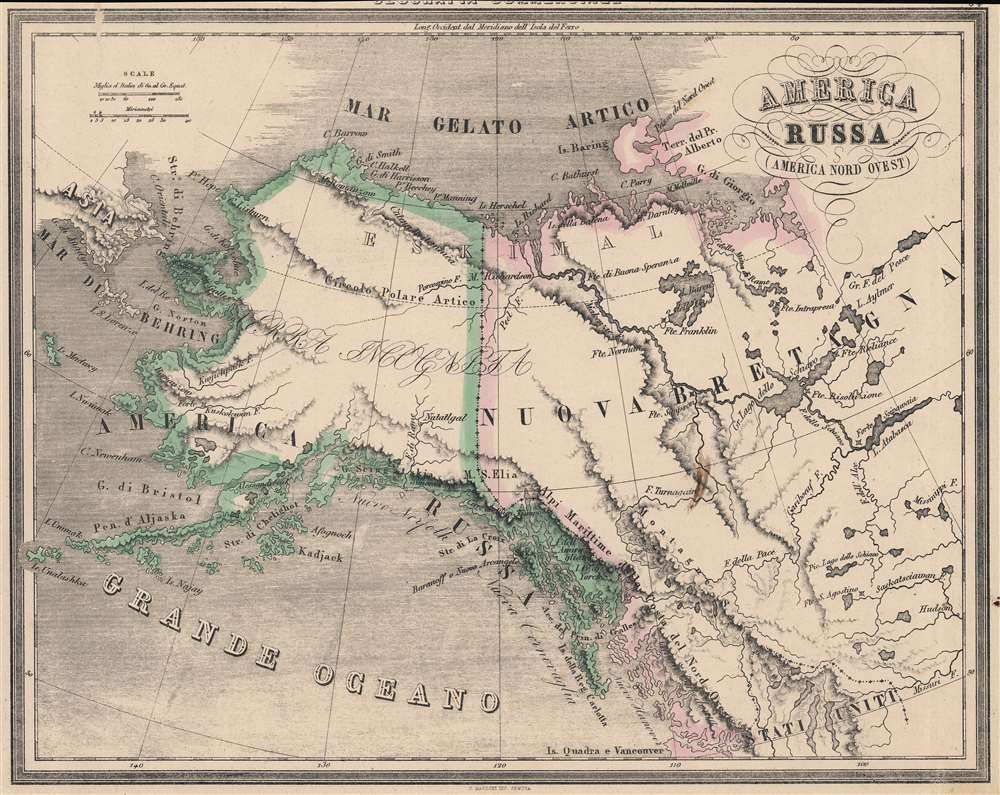
America Russa. (America Nord Ovest).
1858 (undated) 10.75 x 13 in (27.305 x 33.02 cm) 1 : 11025000
1858 (undated) 10.75 x 13 in (27.305 x 33.02 cm) 1 : 11025000
Description
An appealing Italian map of Alaska, northwest Canada, and the Bering Strait produced by Francesco Marmocchi for his 1858 work Il Globo Atlante di Carte Geografiche. It depicts 'Russian America' in its final days, when the Tsarist government began considering proposals to sell the territory.
Hand-colored outlines are used to distinguish Russian (green) from British (pink) territory. A nicely engraved title cartouche sits at top-right. Recent discoveries in the Arctic are included, such as Baring Island (Banks Island), spotted by Sir William Edward Parry in 1820 and confirmed by the 1850 McClure Arctic Expedition.
Although never numbering more than 700, the Russians did establish a settlement at Novo-Arkhangelsk (now Sitka) as well as outposts on the coast of California and in Hawaii. They had a major impact on the native inhabitants of the Aleutians and mainland Alaska, with some 80 percent of the indigenous population dying from disease within two generations, not to mention those killed in violent conflict. The environmental effects were similarly severe, as the population of animals hunted for their furs (especially seals and otters) declined dramatically, becoming a major source of tension with indigenous Alaskans.
In the end, the colony was relatively costly to maintain, as well as being not especially profitable due to the distances involved and the general reduction of the furrieries. By the 1860s, the Russians expected the Americans, British, or some other power to try to grab Alaska and preferred that it not go to their great rival Britain, which they feared could use Canada as a base to encroach on Siberia. The Tsar was also desperate for money to pay for Russia's costly loss in the Crimean War. It therefore made sense to sell Russia's American colony to the United States in 1867.
A Closer Look
Coverage extends from the Chukchi Peninsula and the Bering Strait in the west to Lake Athabasca (Saskatchewan) in the east and from the Arctic Sea in the north to Vancouver in the south. 'Baranoff o Nuovo Arcangelo,' the largest Russian settlement in America, is today Sitka.Hand-colored outlines are used to distinguish Russian (green) from British (pink) territory. A nicely engraved title cartouche sits at top-right. Recent discoveries in the Arctic are included, such as Baring Island (Banks Island), spotted by Sir William Edward Parry in 1820 and confirmed by the 1850 McClure Arctic Expedition.
The Last Days of Russian America
Russian interest in America was largely the result of two processes - Russian expansion into Siberia and maritime exploration of the Arctic and Pacific. As in Siberia, Russia also had a distinct economic interest in harvesting natural resources from the region, namely furs. In 1799, Tsar Paul I issued a decree (Ukase) that claimed lands north of the 55th parallel and gave exclusive privileges to the Russian-American Company (an outgrowth of the pre-existing United-American Company or Shelikhov-Golikov Company).Although never numbering more than 700, the Russians did establish a settlement at Novo-Arkhangelsk (now Sitka) as well as outposts on the coast of California and in Hawaii. They had a major impact on the native inhabitants of the Aleutians and mainland Alaska, with some 80 percent of the indigenous population dying from disease within two generations, not to mention those killed in violent conflict. The environmental effects were similarly severe, as the population of animals hunted for their furs (especially seals and otters) declined dramatically, becoming a major source of tension with indigenous Alaskans.
In the end, the colony was relatively costly to maintain, as well as being not especially profitable due to the distances involved and the general reduction of the furrieries. By the 1860s, the Russians expected the Americans, British, or some other power to try to grab Alaska and preferred that it not go to their great rival Britain, which they feared could use Canada as a base to encroach on Siberia. The Tsar was also desperate for money to pay for Russia's costly loss in the Crimean War. It therefore made sense to sell Russia's American colony to the United States in 1867.
Publication History and Census
This map appeared as Plate 34 in Francesco Marmocchi's Il Globo Atlante di Carte Geografiche, published in 1858, the year of Marmocchi's death. The maps in the atlas retained the title of his earlier work 'Geografia Commerciale' on their plates, and the margin and the margin may have been cut close to obscure the title and avoid confusion. It was engraved by C. Magrini and published by Paolo Rivara in Genoa. It is only cataloged among the holdings of the University of Alaska, Fairbanks and is scarce to the market, while the entire atlas is held by the David Rumsey Historical Map Collection, the Newberry Library, and the National Library of Australia.Cartographer
Francesco Costantino Marmocchi (August 26, 1805 - September 9, 1858) was an Italian geographer. Following in the footsteps of his father, a professor of physics, he began his studies in the natural sciences. He became involved in the Italian nationalist movement and was an associate of Guiseppi Mazzini, leading to his being arrested and briefly imprisoned before being put under house arrest in his hometown of Poggibonsi. He tried to move to Naples under a pseudonym, but was discovered and was forced to leave, settling in Rome. He then focused on publishing, producing translations, original works, and managing a popular broadsheet dedicated to scientific discoveries. More by this mapmaker...
Source
Marmocchi, Francesco C., Il Globo Atlante di Carte Geografiche, (Paolo Rivara: Genoa) 1858.
Condition
Good. Margin trimmed closely. A few sporadic smudges and creases, including one bisecting the neatline and border at top-left.
References
Rumsey 12235.035. OCLC 892492698.