This item has been sold, but you can get on the Waitlist to be notified if another example becomes available, or purchase a digital scan.
1775 Sayer Map of the Bering Strait, East Asia, and the Pacific Northwest
AlaskaSiberia-sayer-1775$725.00

Title
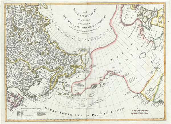
The Russian Discoveries, from the Map Published by the Imperial Academy of St. Petersburg.
1775 (dated) 18.5 x 25 in (46.99 x 63.5 cm) 1 : 19000000
1775 (dated) 18.5 x 25 in (46.99 x 63.5 cm) 1 : 19000000
Description
A beautiful example of Robert Sayer's 1775 map of the Pacific Northwest, Alaska, the Bering Strait and Siberia, this is considered to be the first English edition of Fredrich Muller's seminal map. Issued after the seminal explorations of Vitus Bering (1733–1743) on the Asia side of his namesake strait, but before the voyages of Captain James Cook similarly mapped the American side of the Bering Strait, this map is a smorgasbord of cartographic speculation – such as the exceptionally fine delineation of Freidrich Muller's Peninsula (Alaska / Aleutians). Centered on the Bering Strait, the map covers from Chinese Tartary to the Hudson Bay, and from the high Arctic, south as far as New Mexico, and Honshu (Japan). There is a striking contrast between the well explored Asiatic regions and the starkly bare and highly speculative mapping of America.
In the middle part of the 18th century there were few paces on Earth as remote or as little known as the American Northwest and the Siberian Northeast in the vicinity of the modern-day Bering Strait. The first major scientific incursion in to this region was the 1733 - 1743 Great Northern Expedition led by Vitus Bering and Aleksei Chirikov. The expedition was widely discussed in European scientific circles, but Bering and Chirikov's actual discoveries were suppressed by the Russian Academy of Sciences until 1747 when Joseph-Nicholas De L'Isle, younger brother of the famous French cartographer Guillaume De L'Isle, and who was then working in Russia for the Tzar, fled Russia and published a preliminary interpretation of the Bering-Chirikov discoveries in partnership with Philippe Buache. Buache incorporated some of the unpublished cartographic musings of Guillaume De L'Isle, who was by then deceased, to fill in the then largely unknown northeastern parts of America.
The St. Petersburg Academy of Sciences was understandably offended by the unofficial leak of knowledge from the Great Northern Expedition and sponsored the German cartographer Gerhard Freidrich Muller to issue an official response map to De L'Isle/Buache. That map, which was published in 1754, and which is referenced in the title above, was the first to contain substantial accurate information with regard to Russian discoveries it the Pacific Northwest and is the basis for much of the cartography seen here, including the Muller's most significant innovation, the so-called Muller Peninsula.
The Muller Peninsula is a large speculative peninsula that bears a vague resemblance to Alaska. It was postulated by Muller based upon his reading of the Bering-Chirikov reports. As shown here on Sayer's map, we can follow the track of the expedition as Bering and Chirikov skirt the Aleutian Islands, sighting land on numerous occasions, before reaching the North American mainland and sighting Mount Saint Elias (Mont de St. Elie). One has no difficulty understanding how, by drawing a line between Bering's sightings of the Aleutian Islands, Muller presumed them connected in the form of a vast Arctic peninsula. Despite the exaggerated westward proportions of Muller's Peninsula, his mapping, as seen here, is significant in that it
Dezhnyov ultimately proved that there was indeed a nautical route from Russia to East Asia, but at the same time confirmed that it was exceedingly impractical for trade. Nonetheless, his promontory was subsequently embraced by European cartographers who, lacking serious scientific data from the Dezhnyov expedition, surmised the form. The first of these was Dutchman Nicholaas Witsen, who prepared a map in 1687 based upon Dezhnyov's records that he discovered on a 1665 trip to Moscow – hence the term Witsen’s Peninsula. Many cartographers followed suit, and some even went so far as to suggest that this landmass may actually be connected to America. Dezhnyov's actual reports were rediscovered by Gerhardt Friedrich Muller who published them in 1758 and incorporated them into his own influential map of the Siberian Arctic.
Beyond the discovery of Mount Saint Elias, much of the Pacific Northwest is notably blank. Along the west coast, the map notes the speculative River of the West, supposedly discovered by Martin D' Aguilar in 1603, the factual Strait of Juan de Fuca falsely attributed to Jean de Fuca (1592), and further north the supposed river entrance discovered of Admiral De Fonte, to which Sayer correctly gives little credit. All of these are present to suggest that Sayer has not yet given up hope that an inland river route might exist between the Hudson Bay and the Pacific. Nevertheless, between these discoveries and Lake Winnipeg (Ouinipigon) there is little content.
This map was published in London by Robert Sayer in March of 1775, on the cusp of Captain James Cook's historic voyages of discovery which would ultimately shed light on much of this region. Because of the rapid redefining of this region in the second half of the 18th century, this map had a short lifespan and, despite it's great historical importance, is rarely seen on the market. An essential item for any serious collection focused on the Arctic or the Pacific Northwest.
In the middle part of the 18th century there were few paces on Earth as remote or as little known as the American Northwest and the Siberian Northeast in the vicinity of the modern-day Bering Strait. The first major scientific incursion in to this region was the 1733 - 1743 Great Northern Expedition led by Vitus Bering and Aleksei Chirikov. The expedition was widely discussed in European scientific circles, but Bering and Chirikov's actual discoveries were suppressed by the Russian Academy of Sciences until 1747 when Joseph-Nicholas De L'Isle, younger brother of the famous French cartographer Guillaume De L'Isle, and who was then working in Russia for the Tzar, fled Russia and published a preliminary interpretation of the Bering-Chirikov discoveries in partnership with Philippe Buache. Buache incorporated some of the unpublished cartographic musings of Guillaume De L'Isle, who was by then deceased, to fill in the then largely unknown northeastern parts of America.
The St. Petersburg Academy of Sciences was understandably offended by the unofficial leak of knowledge from the Great Northern Expedition and sponsored the German cartographer Gerhard Freidrich Muller to issue an official response map to De L'Isle/Buache. That map, which was published in 1754, and which is referenced in the title above, was the first to contain substantial accurate information with regard to Russian discoveries it the Pacific Northwest and is the basis for much of the cartography seen here, including the Muller's most significant innovation, the so-called Muller Peninsula.
The Muller Peninsula is a large speculative peninsula that bears a vague resemblance to Alaska. It was postulated by Muller based upon his reading of the Bering-Chirikov reports. As shown here on Sayer's map, we can follow the track of the expedition as Bering and Chirikov skirt the Aleutian Islands, sighting land on numerous occasions, before reaching the North American mainland and sighting Mount Saint Elias (Mont de St. Elie). One has no difficulty understanding how, by drawing a line between Bering's sightings of the Aleutian Islands, Muller presumed them connected in the form of a vast Arctic peninsula. Despite the exaggerated westward proportions of Muller's Peninsula, his mapping, as seen here, is significant in that it
confirmed the existence of a body of water between Asia and America, the subject of much dispute during the previous two hundred years. It also showed the Kurile Islands correctly and suggested the outline of Alaska and the Aleutian chain. Though the Russian discoveries had been shown on the De L'Isle map ... published in 1752, … this is the first map to give an approximate picture of what is now Alaska.Another feature of extreme interest is the ghosted bulbous peninsula identified as Tschuktschi in northeastern Siberia. Earlier versions of this were known as Witsen’s Peninsula. This oddity appears in various forms on numerous maps dating from the late 17th and early 19th century. It is a legacy of Peter the Great's obsession over the search for a Northeast Passage. Around 1648, the Cossack Semen Ivanovich Dezhnyov (1605 - 1673) put together a rough and ready expedition to explore the region. His company consisted of Fedot Alekseyev, traveling with the merchants Andreev and Afstaf'iev (representing the Guselnikov merchant house), who provided their own ship, and Gerasim Ankudinov, an experienced sea captain with his own ship and some 30 men. Dezhnev, along with Mikhail Stadukhin, recruited some 19 men of their own and procured a traditional kocha ship. Including escort vessels, a total seven ships sailed from the mouth the Kolyma River, along the Siberian Arctic, to the Anadyr River north of Kamchatka, and in doing so became the first Europeans to sail through the Bering Strait some 80 years before Vitus Bering. Dezhnyov described rounding a large mountainous promontory identified as Chukchi, Tschuktschi, or Chukotka Peninsula. Of the seven vessels the multiple leaders, only three ships, including Dezhnev’s, survived the passage.
Dezhnyov ultimately proved that there was indeed a nautical route from Russia to East Asia, but at the same time confirmed that it was exceedingly impractical for trade. Nonetheless, his promontory was subsequently embraced by European cartographers who, lacking serious scientific data from the Dezhnyov expedition, surmised the form. The first of these was Dutchman Nicholaas Witsen, who prepared a map in 1687 based upon Dezhnyov's records that he discovered on a 1665 trip to Moscow – hence the term Witsen’s Peninsula. Many cartographers followed suit, and some even went so far as to suggest that this landmass may actually be connected to America. Dezhnyov's actual reports were rediscovered by Gerhardt Friedrich Muller who published them in 1758 and incorporated them into his own influential map of the Siberian Arctic.
Beyond the discovery of Mount Saint Elias, much of the Pacific Northwest is notably blank. Along the west coast, the map notes the speculative River of the West, supposedly discovered by Martin D' Aguilar in 1603, the factual Strait of Juan de Fuca falsely attributed to Jean de Fuca (1592), and further north the supposed river entrance discovered of Admiral De Fonte, to which Sayer correctly gives little credit. All of these are present to suggest that Sayer has not yet given up hope that an inland river route might exist between the Hudson Bay and the Pacific. Nevertheless, between these discoveries and Lake Winnipeg (Ouinipigon) there is little content.
This map was published in London by Robert Sayer in March of 1775, on the cusp of Captain James Cook's historic voyages of discovery which would ultimately shed light on much of this region. Because of the rapid redefining of this region in the second half of the 18th century, this map had a short lifespan and, despite it's great historical importance, is rarely seen on the market. An essential item for any serious collection focused on the Arctic or the Pacific Northwest.
Cartographer
Robert Sayer (1725 - January 29, 1794) was an important English map publisher and engraver active from the mid to late 18th century. Sayer was born in Sunderland, England, in 1725. He may have clerked as a young man with the Bank of England, but this is unclear. His brother, James Sayer, married Mary Overton, daughter-in-law of John Overton and widow of Philip Overton. Sayer initially worked under Mary Overton, but by December of 1748 was managing the Overton enterprise and gradually took it over, transitioning the plates to his own name. When Thomas Jefferys went bankrupt in 1766, Sayer offered financial assistance to help him stay in business and, in this way, acquired rights to many of the important Jefferys map plates as well as his unpublished research. From about 1774, he began publishing with his apprentice, John Bennett (fl. 1770 - 1784), as Sayer and Bennett, but the partnership was not formalized until 1777. Bennett retired in 1784 following a mental collapse and the imprint reverted to Robert Sayer. From 1790, Sayer added Robert Laurie and James Whittle to his enterprise, renaming the firm Robert Sayer and Company. Ultimately, Laurie and Whittle partnered to take over his firm. Sayer retired to Bath, where, after a long illness, he died. During most of his career, Sayer was based at 53 Fleet Street, London. His work is particularly significant for its publication of many British maps relating to the American Revolutionary War. Unlike many map makers of his generation, Sayer was a good businessman and left a personal fortune and great estate to his son, James Sayer, who never worked in the publishing business. More by this mapmaker...
Condition
Very good. Blank on verso. Minor wear and verso reinforcement along original centerfold.
References
OCLC 733397356.