This item has been sold, but you can get on the Waitlist to be notified if another example becomes available, or purchase a digital scan.
1758 Scots Magazine Map of Albany, Lake George and Lake Champlain
AlbanyCrownPoint-phinn-1758$250.00

Title
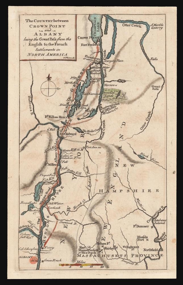
The Country between Crown Point and Albany being the Great Pass from the English to the French Settlements in North America.
1758 (undated) 7.5 x 4.25 in (19.05 x 10.795 cm) 1 : 1020000
1758 (undated) 7.5 x 4.25 in (19.05 x 10.795 cm) 1 : 1020000
Description
This is a rare 1858 map of a key theatre of the French and Indian War, engraved by Thomas Phinn in Edinburgh to satisfy readers hungry for news. Although of broader scope, it is remarkable in pre-dating the famous Brasier map of Lakes Champlain and George, the earliest separate map specifically of those lakes. The Brasier surveys began after the publication of the present map.
This map serves as the basis for another magazine-published map, the nearly-identical A map of the country between Crown Point and Albany with the situation of Ticonderoga: being the present theatre of war of the British forces under the command of Genl. Carleton, published in the 1770s in the wake of the British efforts to recover from their shocking defeat at Ticonderoga.
A Closer Look
Phinn's map covers from Albany and the northwest corner of Massachusetts in the south, reaching to southern Lake Champlain. Otter Creek in Vermont is shown as per the Jefferys/ Mead Map of the Most Inhabited Part of New England, from which much of the detail of this map is taken. Several features are drawn from other sources: the 'Drowned Lands' east of Lake George, for example, and the wagon road following the Hudson from Albany to Lake Champlain. The map features key strongpoints along the route from Champlain to Albany: Fort Frederick at Crown Point; Ticonderoga (or carry long, a mondegreen of Carrilon); Fort William Henry; Fort Ann; also Forts Edward and Miller on the Hudson. In addition, wagon roads marked as 'Indian Paths' range through what would become southern Vermont. The border of Massachusetts is also marked with fortifications, mainly on the Connecticut River and its tributaries.This map serves as the basis for another magazine-published map, the nearly-identical A map of the country between Crown Point and Albany with the situation of Ticonderoga: being the present theatre of war of the British forces under the command of Genl. Carleton, published in the 1770s in the wake of the British efforts to recover from their shocking defeat at Ticonderoga.
Publication History and Census
This map was engraved by Thomas Phinn in 1758 for inclusion in volume 20 of the Scots Magazine. It has been overlooked by most institutional collections, being listed separately only by the New York Public Library and the National Library of Scotland.CartographerS
Thomas Phinn (March 1728 - 1771) was a Scots engraver and illustrator. He worked for William Jeffrey and produced a number of maps for The Scots Magazine and the Edinburgh Magazine, and a variety of other publications. More by this mapmaker...
Thomas Jefferys (1695 - November 20, 1771) was one of the most prominent and prolific map publishers and engravers of his day. Jefferys was born in Birmingham and was apprenticed to the engraver Emmanuel Bowen in 1735. Later, in the 1740s he engraved several maps for the popular periodical Gentleman's Magazine. Around 1740 Jefferys was finally able to go into business for himself and in 1746 received an appointment as 'Geographer to Fredrick, Prince of Wales,' which shortly after translated to the position of 'Royal Cartographer to King George III.' Jefferys initially specialized in compiling and re-engraving the works of earlier cartographers into more coherent cartographic wholes. Later, while not salaried position, Jefferys' appointment as 'Royal Cartographer' guaranteed preferential access to the most up to date cartographic material available, allowing him to produce new and updated charts of exceptional accuracy. He his best known for his maps of the Americas, particularly the posthumously published 1775 American Atlas, which included some of the finest and most important late colonial era maps of America ever made. Despite his prolific publishing history, royal appointments, and international publishing fame, Jefferys lived most of his life in dire economic straits. He was bailed out of bankruptcy by Robert Sayer during the production of the American Atlas. In the end, Jefferys died suddenly with very little to his name. Nonetheless, his cartographic legacy survived, and even after his death in 1771, many of his important maps continued to be published and republished by Sayer and Bennet, Conrad Lotter, Georges Louis Le Rouge, Laurie and Whittle, and others. Many attribute some of Jefferys best maps to the colorful and criminally inclined Irish cartographic genius Braddock Mead (John Green, c. 1688 - 1757), who is considered the 'secret behind Jefferys.' Jefferys was succeeded by his son, also Thomas, who had little success as a cartographer and eventually partnered with, then sold his stock and plates to William Faden - Jefferys' true heir. Learn More...
Braddock Mead (c. 1688 - 1757), also known as John Green, was an Irish cartographer and map engraver active in London during the middle part of the 18th century. Mead is one of the most interesting and colorful figures in cartography whose louche personal life sharply contrasted with the high standard of his maps. Mead was born in Ireland around 1688 and seems to have come from a good family and received a respectable education. His brother Thomas Mead held the position of Lord Mayor of Dublin in 1757. Braddock Mead left Dublin for London around 1717 where he plunged into vice, subsidizing his cartographic work with hack work and gambling. In 1728 Mead fell in with a plot to defraud a 12 year old Irish heiress, Bridget Reading, of her fortune by kidnapping and marrying her himself. Mead suffered jail time for the crime but was more fortunate than his partner, a fellow Irishman named Kimberly, who was hanged. As a cartographer Mead cannot have exhibited a more antithetical character. He held himself and others to the highest standards of accuracy and scholarship, and issued a call for greater transparency in the field of mapmaking. Mead worked with Ephraim Chambers on the Universal Dictionary, as well as with Cave and Astley in the publication of various travelogues and explorer's journals, notably Astley’s New General Collection of voyages and travels. Eventually he came to work for the publishing house of Thomas Jefferys, who saw through Mead's personal failings to appreciate his cartographic brilliance. Mead has been called the genius behind Jefferys and he seems to have had a hand in the production of many of Jefferys' most important maps. William Cumming notes that Mead
had a number of marked characteristics as a cartographer ... One was his ability to collect, to analyze the value of, and to use a wide variety of sources; these he acknowledged scrupulously on the maps he designed and even more fully in accompanying remarks. Another outstanding characteristic was his intelligent compilation and careful evaluation of reports on latitudes and longitudes used in the construction of his maps, which he also entered in tables on the face of the maps ... Mead's contributions to cartography stand out ... At a time when the quality and the ethics of map production were at a low ebb in England, he vigorously urged and practiced the highest standards; in the making of maps and navigational charts he was in advance of his time. For this he deserves due credit.Learn More...
Source
The Scots Magazine vol 20, (Edinburgh: Sands) 1758.
Condition
Very good. Mended tear entering image at top, with no loss.
References
OCLC 316360190.