This item has been sold, but you can get on the Waitlist to be notified if another example becomes available, or purchase a digital scan.
1854 Spruner Map of the Empire of Alexander the Great
AlexandriMagni-spruner-1854$80.00

Title
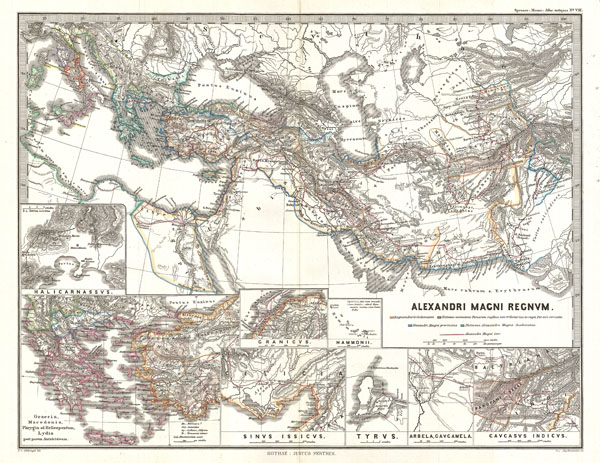
Alexandri Magni Regnum.
1854 (undated) 12.5 x 16 in (31.75 x 40.64 cm)
1854 (undated) 12.5 x 16 in (31.75 x 40.64 cm)
Description
A fascinating 1854 historical map of the Empire of Alexander the Great. Shows Alexander's conquests at their fullest extent covering from Italy to the mouths of the Indus River and from the Black Sea to the Nile Valley. A series of insets in the lower quadrants of the map depict various sites associated with Alexander's most important battles, including Halicarnassus, Sinus Issicus, Cranicus, Hammonii, Tyrus (Tyre), Arbela, Gavcamela, and Caucasus Indicus. A further inset in the lower left quadrant details Greece, Macedonia, and the Aegean. The overall style of this map is typical of German cartographic work form the middle part of the 19th century. It is characterized by high quality woven papers, extremely fine steel plate engraving work, high levels of detail, and minimal but intense outline-style color work. Drawn by A. Hanemann and F. von Stulpnagel and published by Justus Perthes in Karl von Spruner's 1854 Hand Atlas.
Cartographer
Johan Georg Justus Perthes (September 11, 1749 - May 2, 1816) was one of the most important German cartographic engravers of the 19th century. He was born in the Thuringian town of Rudolstadt, the son of a court physician. In 1778, he began working as a bookseller in Gotha. Perthes began his publishing empire shortly thereafter with the 1784 issue of the famed survey of European nobility known as the Almanac de Gotha. In the next year, 1785, he founded the cartographic firm of Justus Perthes Geographische Anstalt Gotha. His son Wilhelm Perthes (1793 - 1853) joined the firm in 1814. Wilhelm had prior publishing experience at the firm of Justus Perthes' nephew, Friedrich Christoph Perthes, who ran a publishing house in Hamburg. After Justus Perthes died in 1816, Wilhelm took charge and laid the groundwork for the firm to become a cartographic publishing titan. From 1817 to 1890. the Perthes firm issued thousands of maps and more than 20 different atlases. Along with the visionary editors Hermann Berghaus (1797 - 1884), Adolph Stieler (1775 - 1836), and Karl Spruner (1803 - 1892), the Perthes firm pioneered the Hand Atlas. When Wilhelm retired, management of the firm passed to his son, Bernhardt Wilhelm Perthes (1821 – 1857). Bernhardt brought on the cartographic geniuses August Heinrich Peterman (1822 - 1878) and Bruno Hassenstein (1839 - 1902). The firm was subsequently passed to a fourth generation in the form of Berhanrd Perthes (1858 – 1919), Bernhard Wilhelm's son. The firm continued in the family until 1953 when, being in East Germany, it was nationalized and run as a state-owned enterprise as VEB Hermann Haack Geographisch-Kartographische Anstalt Gotha. The Justus family, led by Joachim Justus Perthes and his son Wolf-Jürgen Perthes, relocated to Darmstadt where they founded the Justus Perthes Geographische Verlagsanstalt Darmstadt. More by this mapmaker...
Source
Spruner, Karl von, Historisch-Geographischer Hand-Atlas zur Geschichte der Staaten Europa's von Anfang des Mittelalters Bis Auf Dies Neueste Zeit, (Gotha, Justus Perthes) 1854.
Condition
Very good. Original centerfold. Blank on verso.
References
Rumsey 1626.008. Phillips (Atlases) 3288. Espenhorst, J., Petermann's Planet, p. 397-404. Espenhorst, J. Andree, Stieler, Meyer & Co., p. 148.