
1946 Greyhound Pictorial Map of the United States

This item has been sold.
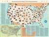
Greyhound's Picture Map of 'This Amazing America'.
Go Greyhound and Leave the Driving to Us!
Choose a Collection:
- Digital Map Information
- Suitable for large format printing
- Full resolution TIFF file
- ICC color profile embedded
- Delivered instantly via download link
This Item
Enquire
Go Greyhound and Leave the Driving to Us!
This is a 1946 Greyhound pictorial map of the United States. Pictorial vignettes highlight American culture, landscape, and history. National parks, including Yosemite, Yellowstone, Mesa Verde, and the Great Smoky Mountains, are among the illustrated sites. Historical landmarks include the Statue of Liberty, Independence Hall, and the site of man's first powered flight at Kitty Hawk, North Carolina. Cultural references include Paul Bunyan in Minnesota, Hollywood California, and Frontier Days in Cheyenne, Wyoming. Each vignette is numbered and corresponds with a short reference text situated either to the left side or below the map. An inset in the lower left details Greyhound's extensive nationwide bus network.Publication History and Census
This map was created and published by the Greyhound Corporation in 1946. We note three cataloged examples in OCLC, part of the collections at the University of Michigan, the University of Florida, and the University of Texas at Arlington. We also note that an example in the David Rumsey Map Collection.Condition
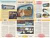
Very good. Exhibits wear along original fold lines. Exhibits light soiling. Text and printed images on verso.
References
Rumsey 9878.003. OCLC 903505965.