This item has been sold, but you can get on the Waitlist to be notified if another example becomes available, or purchase a digital scan.
1841 Wyld Map of the Western Hemisphere w/ Republic of Texas
America-wyld-1841$112.50

Title
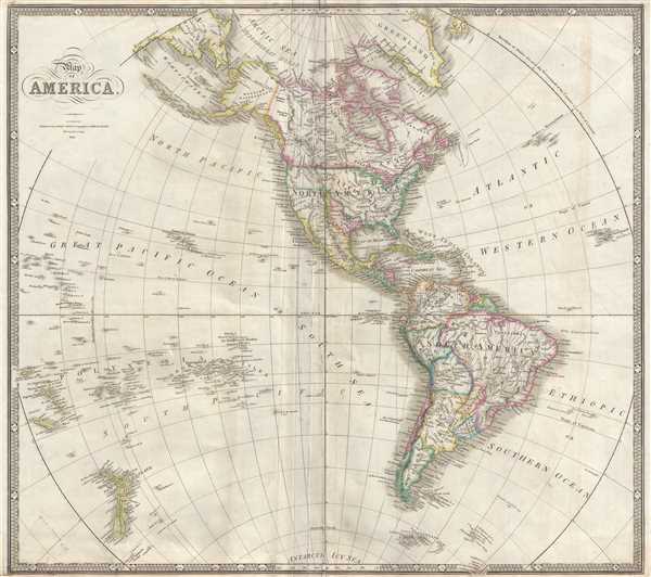
Map of America.
1841 (dated) 21 x 23.5 in (53.34 x 59.69 cm) 1 : 38200000
1841 (dated) 21 x 23.5 in (53.34 x 59.69 cm) 1 : 38200000
Description
This is an 1841 James Wyld map of the Western Hemisphere, including the Republic of Texas. The map depicts the region from the New Hebrides and New Caledonia in the Pacific to the Cape Verde Islands in the Atlantic and from the Arctic Ocean to New Zealand and the South Shetland Islands. Created almost precisely in the middle of the existence of the Republic of Texas, the Republic is highlighted in light pink and features the border as claimed by Texas along the Rio Grande River. It also nearly illustrates what has become known as the 'stove pipe' configuration of the Republic, though it is not perfectly discernable.
The Geography of the Republic of Texas
The geography of Texas illustrated here is unusual, as it does not conform to Texas's claim to all land east of the Rio Grande, which extended north to modern-day Wyoming, to the U.S. border, which at that time was the Arkansas River. The Republic of Texas would exist for another five years, until Texas was formally admitted to the United States in December 1845 and ceded its sovereignty to the United States on February 19, 1846. The annexation of Texas led to a deterioration of foreign relations between the United States and Mexico due to an unresolved border dispute between Texas and Mexico and directly led to the Mexican-American War.
Mriad locations are labeled throughout North, Central and South America. Cities, such as New York, Boston, Philadelphia, Charleston, Veracruz, Guadalajara, Caracas, Quito, Rio de Janeiro, Buenos Aires, and Santiago are all present, along with rivers (the Amazon and the Mississippi), and the Great Lakes. The Erie Canal, which ran from Lake Erie to Albany, is also illustrated. As the Mexican-American War was still five years away, the border between the United States and Mexico was still fixed at 42nd parallel, meaning that most of what constitutes the modern American Southwest was still a part of Mexico. In the Pacific, numerous archipelagos are illustrated and labeled, usually to a degree of detail such that individual islands bear labels. In one such archipelago, the Hawaiian archipelago (labeled here as the Sandwich Islands), the islands bear names that are nearly identical to those used today, although the phonetic spellings differ greatly from today's versions.
This map was created and published by James Wyld in 1841.
Cartographer
Wyld (1823 - 1893) was a British publishing firm active throughout the 19th century. It was operated by James Wyld I (1790 - 1836) and his son James Wyld II (November 20, 1812 - 1887) were the principles of an English mapmaking dynasty active in London during much of the 19th century. The elder Wyld was a map publisher under William Faden (1749 - 1836) and did considerable work on the Ordinance Survey. On Faden's retirement in 1823, Wyld took over Faden's workshop, acquiring many of his plates. Wyld's work can often be distinguished from his son's maps through his imprint, which he signed as 'Successor to Faden'. Following in his father's footsteps, the younger Wyld joined the Royal Geographical Society in 1830 at the tender age of 18. When his father died in 1836, James Wyld II was prepared to fully take over and expand his father's considerable cartographic enterprise. Like his father and Faden, Wyld II held the title of official Geographer to the Crown, in this case, Queen Victoria. In 1852, he moved operations from William Faden's old office at Charing Cross East (1837 - 1852) to a new, larger space at 475 Strand. Wyld II also chose to remove Faden's name from all of his updated map plates. Wyld II continued to update and republish both his father's work and the work of William Faden well into the late 1880s. One of Wyld's most eccentric and notable achievements is his 1851 construction of a globe 19 meters (60 feet) in diameter in the heart of Leicester Square, London. In the 1840s, Wyld also embarked upon a political career, being elected to parliament in 1847 and again in 1857. He died in 1887 following a prolific and distinguished career. After Wyld II's death, the family business was briefly taken over by James John Cooper Wyld (1844 - 1907), his son, who ran it from 1887 to 1893 before selling the business to Edward Stanford. All three Wylds are notable for producing, in addition to their atlas maps, short-run maps expounding upon important historical events - illustrating history as it was happening - among them are maps related to the California Gold Rush, the New South Wales Gold Rush, the Scramble for Africa, the Oregon Question, and more. More by this mapmaker...
Condition
Good. Even overall toning. Light soiling. Exhibits wear, cracks, and other damage around the centerfold. Stabilized and backed on archival tissue. By no means perfect.
References
OCLC 693949704 (1843).