This item has been sold, but you can get on the Waitlist to be notified if another example becomes available, or purchase a digital scan.
1953 Bevans Pictorial Map of the United States w/ American Bison
AmericaBuffalo-bevans-1953$375.00

Title
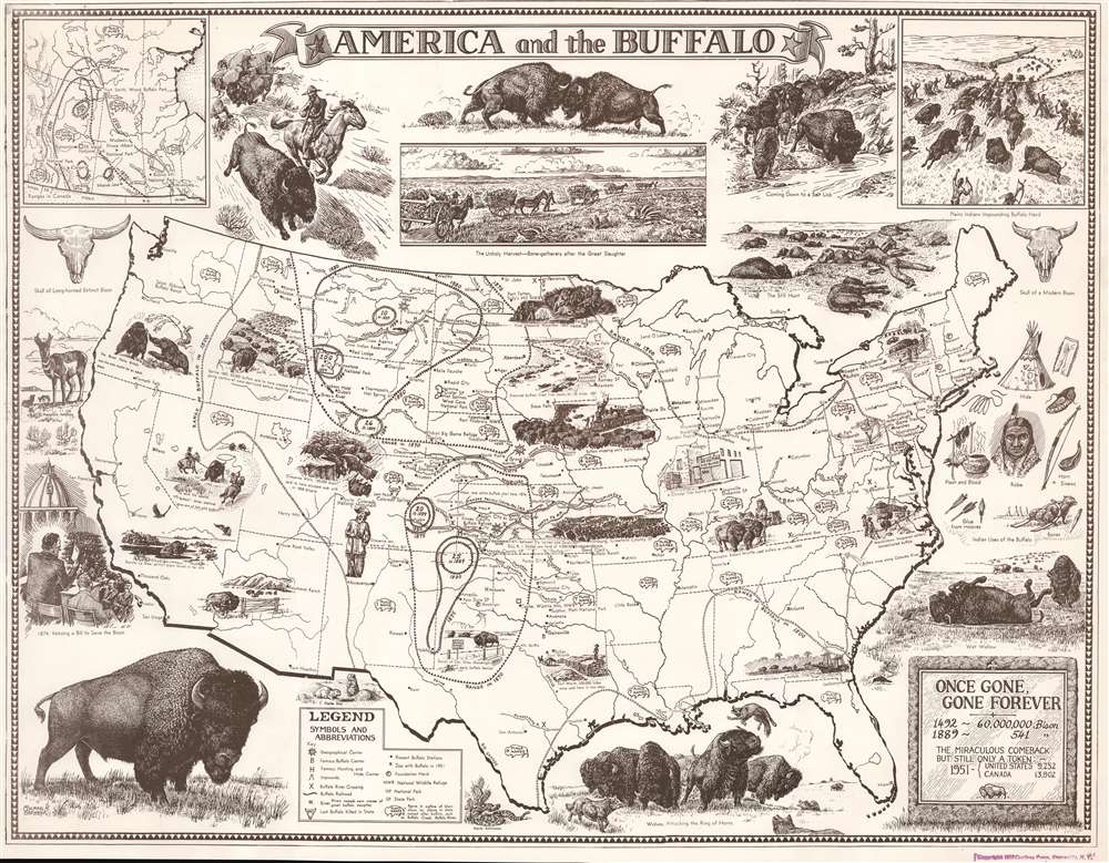
America and the Buffalo: Once Gone, Gone Forever.
1953 (dated) 20.75 x 26.5 in (52.705 x 67.31 cm)
1953 (dated) 20.75 x 26.5 in (52.705 x 67.31 cm)
Description
This is a 1953 Michael H. Bevans pictorial map of the United States celebrating the American bison or buffalo. The map details the bison's historic range at varying dates, chronicling the near extinction and subsequent efforts dedicated to saving the species. A line of circles marks the bison's range as of 1500, stretching from the Atlantic Seaboard west to modern-day Oregon and Nevada. Other lines highlight the bison's precipitous decline in range and population following the arrival of Europeans. Bevans employs buffalo skulls to underscore decimated population and notes in each state the year the last bison was killed.
Vignettes
Pictorial vignettes illustrate how European settlers interacted with the bison. Some depict herds of hundreds of thousands traversing the Great Plains. One of these herds has stopped a train! Unfortunately, passengers are taking advantage of the moment to kill as many as they can. Others recount moments of slaughter and their aftermath, like the 'unholy harvest' of bison bones along the top border. Still others reference the efforts made to save the species from extinction, including 'Buffalo' Jones capturing one of the last live bison in Nevada, bison kept on private ranches, and the vetoing of the 1874 bill to save the bison. Vignettes around the border illustrate bison in natural settings, including fighting for breeding rights, fighting a pack of wolves, and rolling in a wet wallow.Near Extinction and Conservation
As the map states in the lower right, the bison population was decimated between 1492, when there were an estimated sixty million, and 1889, when there were only 541 bison remaining. William Temple Hornaday, a Smithsonian taxidermist, was the first big name to realize the dire situation. He founded the Smithsonian Department of Living Animals in response, and the institution purchased six bison, the first owned by the U.S. government. Not long after Congress created the National Zoo and named Hornady its first director. Shortly after, Hornaday founded the Bronx Zoo, which played a critical role in saving the bison. Even today the Bronx Zoo has an impressive herd of bison. Western herds slowly began to repopulate, and today there are approximately 500,000 bison, although only around 30,000 are wild in national parks.Publication History and Census
This map was created by Michael H. Bevans and published by the Caribou Press in Bronxville, New York in 1953. Six examples are cataloged in OCLC and are part of the collections at the Newberry Library, the Johnson County Library in Mission, Kansas, the school district in Overland Park, Kansas, the Wichita Public Library, the Corpus Christi Public Library, and Washington State University.Cartographer
Michael H. Bevans (1918 - January 3, 1998) was an American artist and writer. Born in New York City, Bevans lived in Madison, Connecticut, beginning in the 1930s. During World War II he played a role in the creation of camouflage. A self-employed artist, his work appeared in Life magazine and he illustrated numerous books published by Double Day. He also created work for the Audobon Society. He was married to Jeanne P. Bevans, with whom he had three children. More by this mapmaker...
Condition
Very good. Stamp stating publishing company and date in lower right corner.