This item has been sold, but you can get on the Waitlist to be notified if another example becomes available, or purchase a digital scan.
1752 Baillieul Wall Map of the Americas
Americas-baillieul-1752$4,750.00


Title
L'Amerique divisée en ses principales parties où sont distingués les uns des autres les estats : selon quils appartiennent presentement aux differents souverains de l'Europe : dressée sur les relations les plus recentes et rectifiées sur les dernieres observations.
1752 (dated) 31 x 40 in (78.74 x 101.6 cm) 1 : 180000
1752 (dated) 31 x 40 in (78.74 x 101.6 cm) 1 : 180000
Description
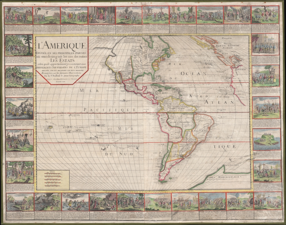
A stunning 1752 wall map of the Americas by Nicolas Baillieul 'le jeune.' Aside from its aesthetic qualities, including elaborate border vignettes, it is also notable for reflecting developing notions of American geography, including tentative mapping of the northwest coast.
European colonies are noted, along with lakes, rivers, mountains, Native American groups, and occasional cities. The tracks of explorers are recorded in the Atlantic and Pacific. A conic projection is employed with a long horizon towards Europe, leading to the British Isles, Scandinavia, and even Russia being depicted at top-right in elongated form.
A Closer Look
Taking in the Americas in their entirety, as known at the time, along with large portions of the Atlantic and Pacific Oceans, this map reveals the state of European geographic knowledge of the New World in the mid-18th century. It has correctly returned California to the mainland of North America and is more modest than later maps in speculations about the geography of the western part of North America. Antarctica is included as 'Indes Meridionales,' with a claimed discovery by the Frenchman Binot Paulmier de Gonneville in 1503 (widely believed in France at the time, but modern research suggests he instead landed in southern Brazil). Baillieul also posits a waterway between the Pacific and Arctic Oceans (discussed below) and a large area of 'terres inconnues' in the vicinity of Alaska. Curiously, the Mississippi River is displayed as connecting to Hudson's Bay via lakes and rivers.European colonies are noted, along with lakes, rivers, mountains, Native American groups, and occasional cities. The tracks of explorers are recorded in the Atlantic and Pacific. A conic projection is employed with a long horizon towards Europe, leading to the British Isles, Scandinavia, and even Russia being depicted at top-right in elongated form.
Cartographic Game of Telephone
Notes on geography and Native American peoples are appear, including an especially interesting one at top about the Attimospiquaies (Tłı̨chǫ Done), or 'dog flank people,' a Dene group with whom the French had only limited contact. Baillieul relates that they were believed to know of a river connecting the Arctic and Pacific Oceans, which is speculatively illustrated to the left of the text.Vignettes
Beautifully colored vignettes illustrate key moments in the European exploration and colonial settlement of the New World, from Columbus, through the conquistadors, and to more recent battles with the English, Spanish, and Native Americans for control of the Americas. Unsurprisingly, these tend to celebrate French victories and diminish rival European powers, such as the discussion at left French naval victories against the English, while the latter were in revolt against their 'Roi légitime Jacques Stuard,' whom the French supported.Publication History and Census
This map was prepared by Nicolas Baillieul le jeune (son of the more famous Gaspard Baillieul) and Jean Louis Daudet in Lyon in 1752. This is the first state of the map, more scarce than the also very rare second state. Baillieul and Daudet collaborated on several other maps in the mid-18th century, including several printings of 'L'Amerique Septentrionale et Meridionale Divisee selon les differentes Possessions,' similar to the present map but smaller, less elaborate, and without the vignettes. The present map is only noted among the holdings of the University of North Carolina at Chapel Hill and the Library of Congress, with the Library of Congress holding the only other known example of this state (G3290 1752 .B2 Copy 2).CartographerS
Nicolas Baillieul (fl. c. 1740 - 1760) was a French engraver, draughtsman, and publisher based in Lyon. He was the son of the more famous Gaspard Baillieul (d. 1744) and inherited his enterprise upon his death, along with Gaspard's other children. Nicolas later relocated to Lyon and published several maps (using the name 'Bailleul le jeune') with the local printer Jean-Louis Daudet. More by this mapmaker...
Jean Louis Daudet (c. 1695 - 1760) was a French engraver and publisher based in Lyon. The family business was founded by his father Etienne Joseph, about whom little is known. Jean Louis took over the firm around 1722 and led it until this death, after which his widow and son-in-law, Louis Martin Roch Joubert, continued it until around 1773. Learn More...
Condition
Good to very good. Two sheets joined and mounted together on fresh linen backing. Areas of surface abrasion with minor loss, especially at right. Stains and creasing in top and bottom margin.
References
OCLC 36509527.