This item has been sold, but you can get on the Waitlist to be notified if another example becomes available, or purchase a digital scan.
1786 Brion de la Tour Map of South and North America
Amerique-brion-1786$175.00

Title
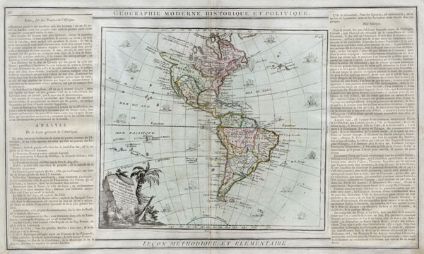
L'Amérique dressée pour l'étude de la géographie.
1786 (dated) 11 x 19 in (27.94 x 48.26 cm)
1786 (dated) 11 x 19 in (27.94 x 48.26 cm)
Description
A hard to find 1786 map of the North America and South America by French cartographer Louis Brion de la Tour. Depicts the whole of North and South America with several interesting cartographic features. The American northwest is largely ill defined though highly suggestive of the French conception of a water route through North America. Notations indicate a great 'Sea of the West' but the exact location of this is left undefined. The region of the Apache American Indian tribe is noted and the Pacific Northwest is labeled 'Albion.' Texas is labled 'Nouvelle Mexique' and shows as distinct from Mexico or 'Nouvelle Espagne.' In South America, Bogata is located in 'Terre Ferme' and some early colonial cities such as Cuzco, Lima, and La Paz are noted. Attractive decorative title cartouche in lower left quadrant. Sixteen sailing ships decorate the oceans. Descriptive text to either side of the map proper.
Cartographer
Louis Brion de la Tour (1743 - 1803) was the Cartographer Royal to the King of France, his official title being Ingenieur-Geographe du Roi. Despite a prolific cartographic career and several important atlases to his name, little is actually known of his life and career. He may have been born in Bordeaux. His son of the same name was born in 1763 and published until his death in 1832. It is nearly impossible to distinguish the work of the father from the work of the son, as both used the same imprint and were active in roughly the same period. Much of their work was published in partnership Louis Charles Desnos (fl. 1750 - 1790). Their most notable work is generally regarded to be his 1766 Atlas General. More by this mapmaker...
Condition
Very good condition. Minor discoloration along original centerfold. Minor buckling to paper - would not be apparent in a framed product.
References
New York Public Library, Map Division, 97-6482 [LHS 1017].