This item has been sold, but you can get on the Waitlist to be notified if another example becomes available, or purchase a digital scan.
1754 Janvier / Lonchamps Wall Map of America w/ Sea of the West
Amerique-janvierlongchamps-1754$6,000.00

Title
L'Amerique Divisee En Tous Ses Pays Et Etats dressée sur de nouveaux Memoires et sur les derniers Observations.
1754 (dated) 47.5 x 60 in (120.65 x 152.4 cm) 1 : 16835000
1754 (dated) 47.5 x 60 in (120.65 x 152.4 cm) 1 : 16835000
Description
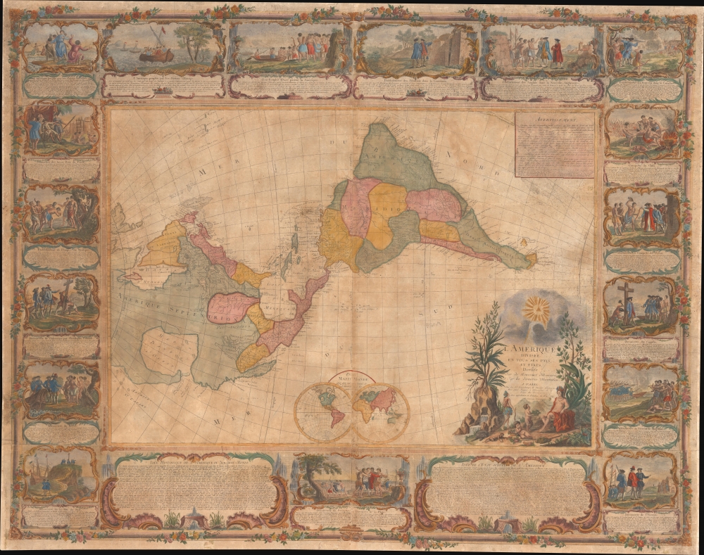
This is a dramatic 1754 east-oriented wall map of the Americas by Jean Janvier and Sebastian G. Longchamps - better known as Voltaire's valet. The dramatic map includes one of cartography's boldest iterations of the Sea of the West. This map appeared at the outset of the French and Indian War (1754 - 1763) and correspondingly details France's bold claims to much of North America.
The whole is surrounded by 17 expertly engraved vignettes depicting scenes of discovery, conquest, and colonization. A further allegorical cartouche appears in the lower right in which America, represented as a woman, receives tributes from putti. In the background, an indigenous American Indian warrior looks to the skies. There, in the place of the sun, he sees the Eye of the Provider through a break in the clouds. The symbol is a reference to the Catholic Trinity and the role of missionaries in colonization. The same symbol was adopted as part of the Great Seal of the United States some 30 years later, then by Freemasonry.
A Closer Look
The publication of this map was first announced in the April 1754 issue of the French literary gazette Mercure de France. The announcement was to be a series of five maps, one for each continent, plus a world map. All of the maps, as here, were elaborately engraved by Gobert-Denis Chambon. This map, intended to fit with the rest of the set, all of which were horizontal, is thus oriented to the east so the longitudinal sprawl of North and South America could be accommodated on a single map.The whole is surrounded by 17 expertly engraved vignettes depicting scenes of discovery, conquest, and colonization. A further allegorical cartouche appears in the lower right in which America, represented as a woman, receives tributes from putti. In the background, an indigenous American Indian warrior looks to the skies. There, in the place of the sun, he sees the Eye of the Provider through a break in the clouds. The symbol is a reference to the Catholic Trinity and the role of missionaries in colonization. The same symbol was adopted as part of the Great Seal of the United States some 30 years later, then by Freemasonry.
The Sea of the West
A magnificent inland sea appears regularly in the American Pacific Northwest on maps created in the mid to late 18th century. This massive and apocryphal body of water, generally referred to as the 'Sea of the West' or 'Mer de l'Ouest', can trace its origins to the great French cartographer Guillaume De L'Isle (1675 - 1726). De L'Isle himself never published a map incorporating the 'Sea of the West' (perhaps suggesting doubt?), but a manuscript map illustrating the Sea of the West was discovered in his notes. It may be that De L'Isle was inspired by a c. 1630 Thames school manuscript map, now located at Yale, that features a geographically similar body of water described as a 'Branch of the South Sea', possibly a revisionist perspective on Verrazano's Sea. The earliest printed map to include the Sea of the West was probably Jean-Baptiste Nolin’s 1742 L’Amerique ou le Nouveau Continent. It has been suggested that Nolin copied the relevant cartography from De l’Isle's manuscript, but it is more likely that information about the 'sea' verbally leaked, as Nolin's sea does not resemble De L'Isle's in any significant way. The first publication of the 'Sea of the West' a la De L'Isle appeared when Joseph Nicholas (1688 - 1768), going through his deceased elder brother's notes discovered the aforementioned manuscript map. At the time, Joseph Nicholas had been working in St. Petersburg with the Tsar's Academy of Sciences and had new information absconded from suppressed records of the Vitus Jonassen Bering (1681 - 1741) expedition that he was keen to publish before an official map was released. In 1752, Joseph Nicholas partnered with Philippe Buache (1700 - 1773) to do just that, using Guillaume De L'Isle's posthumous notes to fill in the American side of the map. The Buache/De L'Isle map featured an accurate Siberian Arctic based on Bering, but in the Americas included a monumental 'Mer d'Ouest' or bay suggestive of a viable Northwest Passage. Although De l’Isle and Buache were immediately accused of fraud, the Sea of the West appeared on many maps, with some editions even post-dating Cook.Publication History and Census
This map was published by Sebastian G. Longchamps and Jean Janvier in the second half of 1754. It was engraved by Gobert-Denis Chambon as part of a set of five maps, including Asia, America, Africa, Europe, and a world map. Longchamps is better known as Voltaire's valet than as a map publisher, leading this and other maps in the series to be frequently misattributed to Pierre Nicolas Buret de Longchamps (1765 - 1839), unlikely as the man was not yet born in 1754. A complete institutional census on this map has proven difficult due to multiple digital and microfilm holdings. Nonetheless, we have identified physical examples at the Clements Library, the University of Illinois, the BnF, and the Library of Congress. It appears from time to time on the market, with at about 4 examples changing hands in the last 20 years.CartographerS
Jean Denis Janvier (fl. 1746 - 1776), sometime also known as 'Robert', was a Paris based cartographer active in the mid to late 18th century. Janvier signed his maps Signor Janvier. By the late 18th century, Janvier was awarded the title of 'Geographe Avec Privilege du Roi' and this designation appears on many of his later maps. Janvier worked with many of the most prominent French, English and Italian map publishers of his day, including Longchamps, Faden, Lattre, Bonne, Santini, Zannoni, Delamarche, and Desnos. More by this mapmaker...
Sebastian G. Longchamps (1718 - 1793) was a manservant and map publisher active in the mid to late 18th century. Longchamps is best known for his long-term employment as the Cirey valet of the French polymath François-Marie Arouet (1694 - 1778), a.k.a. 'Voltaire'. Much of what is known about Longchamps (Longchamp) is obscured as little more than an anecdote in the long shadow of Voltaire, but he was substantial in his own right and worthy of academic attention. Lonchamps' writings on Voltaire are the primary source of information on the author's Cirey period. Less known is Longchamps' map publishing career, which he pursued simultaneously with his valet work. Learn More...
Gobert-Denis Chambon (17?? - 1781) was a French map engraver active in Paris, Rue St. Jean de Beauvais, from the mid to 18th to the early 19th centuries. Learn More...
Condition
Good. Full professional restoration. Some spotting.
References
McGuirk, D., The Last Great Cartographic Myth: Mer de L'Ouest, #31. Library of Congress, G3290 1754.L6 (lacking border vignettes). Wheat, C. I., Mapping of the Transmississippi West, 1540 – 1861, #133. Bibliothèque nationale de France, cb405954862. OCLC 639459454.