This item has been sold, but you can get on the Waitlist to be notified if another example becomes available, or purchase a digital scan.
1852 Bocage Map of North America
AmeriqueSept-bocage-1852$87.50

Title
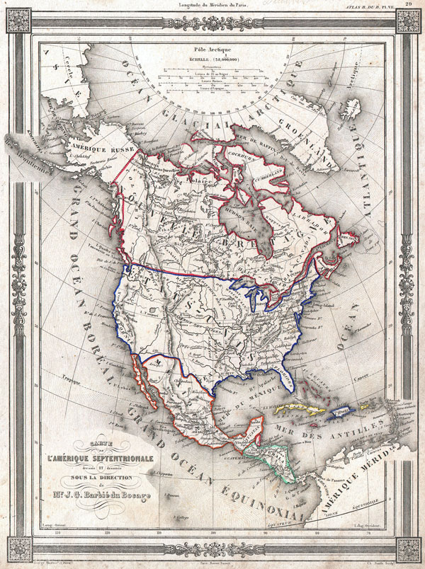
Carte de L'Amerique Septentrionale dresse ET dessinee sous laDirection de Mr. J. G. Barbie du Bocage.
1852 (undated) 12.5 x 9 in (31.75 x 22.86 cm)
1852 (undated) 12.5 x 9 in (31.75 x 22.86 cm)
Description
An uncommon and extremely attractive 1852 map of North America by J. G. Barbie du Bocage. Depicts all of North America from the Arctic Circle to the northern part of South America. The United States is shown shortly after the acquisition of Texas and Upper California though pre-Gadsden Purchase. Texas border is faint but the state is shown at its fullest extent. Names numerous American Indian tribes including the Osages, Sioux and the Mandan. The Great Salt Lake appears as Lake Tampari. Mt. Jefferson, Mt. Sampson, Mt. Long, Mt. James and Mt. Smith are all labeled. Features a beautiful frame style border. Prepared by J. G. Barbie du Bocage for publication as plate no. 29 in Maison Basset's 1852 edition of the Atlas Illustre.
CartographerS
Jean Denis Barbie du Bocage (1760 - 1825) and his son Jean-Guillaume Barbie du Bocage (1795 - 1848) were French cartographers and cosmographers active in Paris during late 18th and early 19th centuries. The elder Barbie du Bocage, Jean Denis, was trained as a cartographer and engraver in the workshops of mapmaking legend J. B. B. d'Anville. At some point Jean Denis held the post of Royal Librarian of France and it was through is associations with d'Anville that the d'Anville collection of nearly 9000 maps was acquired by French Ministry of Foreign Affairs. The younger Barbie du Bocage, Jean-Guillaume, acquired a position shortly afterwards at the Ministry of Foreign Affairs and, in time, became its head, with the title of Geographe du Ministere des Affaires Etrangeres. More by this mapmaker...
Maison Basset (1819 - 1865) was a French publishing concern active through the mid to late 19th century. The firm can trace their roots to André Basset (Bassett; fl. 1768 - 1784), who starting publishing maps, prints, and books around 1768. Maison Basset, also Chez Basset, is the imprint under which the heirs of Paul-André Bassett (1759 - 1829) operated after his death. From their offices at 64 Rue St. Jacques, then 33 Rue de Seine, Paris, France, Maison Basset published the works of such prominent French cartographers and engravers as Barbie du Bocage, A. Vuillemin, J. B. Charle, V. Levasseur, Tu. Duvotenay, H. Dufor, F. E. George, and others. Their library of publications is diverse and vast, but heavily focused on medical and scientific texts, including several important atlases. The firm is closely aligned with the Chéreau family of printers and engravers, with whom they were connected with multiple, often incestuous, marriages and remarriages. Learn More...
Source
Maison Basset, Atlas Illustre, (1852 issue).
Condition
Very good condition. Some marginal foxing, else clean. Blank on verso.