
1815 Brué Map of North America after Louisiana Purchase

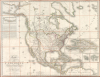
Carte Encyprotype de L'Amérique Septentrionale, Dédiée et présentée à Monsieur, Par M. Brué, Ingénieur-Géographe de S. A. Royale.
One of the earliest large-format maps to illustrate the discoveries of Lewis and Clark.
- Digital Map Information
- Suitable for large format printing
- File Size: 141.05 MB
- File Type: ZIP / TIFF
- ICC color profile embedded
- Delivered instantly via download link
One of the earliest large-format maps to illustrate the discoveries of Lewis and Clark.
This is the first edition of Adrien-Hubert Brué's 1815 map of North America, significant as one of the earliest publications to illustrate cartographically and in detail the achievements of the Lewis and Clark Expedition.A Closer Look
Coverage embraces North America from Baffin Bay to Panama and from the Aleutians to Bermuda. The focus is the United States, particularly the Louisiana territory extending west of the Mississippi towards the Pacific. For this vast region, the cartographer, Brué, makes extensive use of maps and narratives associated with the Lewis and Clark Expedition (1804 - 1806), as well as maps from the explorations of Zebulon Pike (1779 - 1813), Wilson Price Hunt (1783 - 1842), Robert Stuart (1785 - 1848), and others.Lewis and Clark's westernmost camp, Fort Clatsop, is noted at the mouth of the Columbia River, but Fort Astoria, founded by John Jacob Astor in 1811, is not present. Brué thus recognizes British hegemony over most of the Pacific Northwest west of the Rocky Mountains, including modern-day Oregon, Washington, and British Columbia - a topic that would ultimately become a subject of international attention.
Lewis and Clark Expedition (1804 - 1806)
The Lewis and Clark Expedition (1804 - 1806), officially known as the Corps of Discovery Expedition, was a groundbreaking 8,000-mile voyage of discovery commissioned by President Thomas Jefferson (1743 - 1826) shortly after the Louisiana Purchase (1803) to explore and map the newly acquired western territories of the United States. Led by Meriwether Lewis (1774 - 1809) and William Clark (1770 - 1838), the expedition set out from St. Louis, Missouri, traveling up the Missouri River across the vast, largely uncharted North American interior in search of a practical route to the Pacific Ocean. Along the way, the explorers documented the region's geography, flora, fauna, and indigenous peoples, establishing diplomatic relations and gathering invaluable scientific and ethnographic data. With the critical assistance of Sacagawea, a Shoshone woman who served as interpreter and guide, the Corps successfully crossed the Rocky Mountains, reached the Columbia River, and arrived at the Pacific Coast in present-day Oregon. Their return to St. Louis in 1806 completed one of the most significant exploratory achievements in American history, laying the foundation for westward expansion and profoundly shaping the nation's understanding of its continental geography.Despite the significance of the expedition and broad public interest, the Corps of Discovery's cartographic data was slow to emerge. The earliest textual descriptions of the expedition were printed in 1806, including some compiled by Jefferson for a February 1806 report to Congress - some of these were subsequently printed as broadsides and in newspapers. None of these included a map. The first map did not appear until 1814, when Nicholas Biddle and Paul Allen compiled an abridged version of Lewis and Clark's journals into a two-volume narrative. The present map and a similar map by Arrowsmith soon followed the Biddle-Allen map.
The delay in producing a new map of the vast and previously only tenuously understood American West is the result of several factors, including the vast amount of data the Corps collected, Meriwether Lewis's death in 1809, and obstruction by the U.S. government, which considered some of the data 'strategically sensitive' given rising tensions with Spain and Britain over western boundaries.
Sources
Brué helpfully includes an extensive annotation detailing his sources for this map, providing remarkable and valuable insight into both the construction of this map specifically and the compilation of maps generally in the early 19th century.The great number of maps and various works that have been published in recent years on the different parts of North America have enabled us to give this map a perfection and an extent of detail which had not yet been combined. Arrowsmith's map, published in 1795 and corrected in 1814, although the most complete in terms of modern discoveries, does not contain all that its title promises. The lower frame of his map being limited to the parallel of 30°, all the countries south of this parallel up to degrees of latitude, over a development of 575 leagues from north to south, are omitted; thus one would search in vain for the greater part of New Mexico, all of New Spain, the two Floridas, as well as the Greater and Lesser Antilles.
It is by reading the statement of the main materials we have used that one can better judge the degree of superiority of our map over those that have preceded it.
SOURCES
Russian America (Extreme Northwest): The coasts of the Bering Strait; those of the North of the Great Ocean, including the Aleutian Islands; the Alaska Peninsula, going east to the 145° of West longitude are drawn from a map in 4 sheets of the North of the Great Ocean published in St. Petersburg in 1802. The names of the tribes found towards this extremity of America are placed according to the reports of Al Dawidoff, Kaschateff, Rosanoff, and from the expedition of Krusenstern.
West Coasts: New Norfolk, New Cornwall, New Hanover, New Georgia, New Albion, and New California. All these coasts are drawn from the charts of Vancouver's Voyage.
Spanish Possessions: The part comprised between 95°and 120° West longitude is drawn from the large maps published by Mr. de Humboldt, that which is between 2° and 95° West longitude is reduced from the Charts of the West Indies published by Arrowsmith and from that in 6 sheets of the West Indies Islands by Jefferys. For the northern part of New Mexico and especially for placing the sources of the Rio Grande del Norte, we have consulted the maps and the voyage of Pike.
The Antilles, except Dominica: all the coasts of the Antilles Islands have been drawn for the Lesser Antilles from a sea chart published in two by the Spanish Admiralty Depot of Madrid; the Greater Antilles, the Cayman Islands, and the coasts of Florida, after three maps of the same depot, two of which were corrected in 1806 and the third in 1809. For the interior of these islands, we have made use of the maps of Jefferys, of that in 4 sheets published by Arrowsmith and of the map in one sheet of the Caribbean Islands by the same author.
United States: A large part of these states are reduced from particular maps including the State of New Hampshire, by Samuel Holland; the State of Rhode Island, by Harris in 1795; Vermont by Whitelaw in 1809; Ohio by Mansfield; Maryland, by Denis Griffith in 1794; Kentucky by Barker; Pennsylvania by Reading Howell; the Territory of Orleans, West Florida and the Mississippi Territory, according to the map drawn by Lafond in 1806. We have drawn the other states from the map of the United States published by Arrowsmith. For the western part up to and including the course of the Mississippi from 33° of latitude to the source of this river, we have used the precious information provided by the voyage and maps of Pike.
Louisiana: We owe to the voyage of Lewis and Clarke (English Edition) and to that of Pike the greatest part of the interior details of Louisiana. The map of Lafond has served us to trace the lower course of the Red River and its surroundings.
English Possessions (Coasts): The coasts of Newfoundland, the southern ones of Labrador are taken from Lane's map and from the one-sheet map by Arrowsmith. The coasts of Hudson Bay and those near Baffin Bay from a map published by Dalrymple and from the 3-sheet map of the coasts of North America by Arrowsmith. The coasts situated at the northernmost extremity of the continent are: 1. the one seen in 1789 by Mackenzie: we have placed and reduced it according to his particular map. At 20° east of this is another coast seen by Hearne in 1771. This traveler places the Coppermine River at 123 degrees; but Mackenzie having found that the position of Slave Lake is 10° further east than indicated by Hearne, we have deemed it appropriate to also place the discoveries of the latter, 10 degrees further east than he had indicated them.
English Possessions (Interiors): For Upper Canada, we have made use of the one-sheet map by Smith, and the general map of Canada by Arrowsmith. For New Wales and the interior parts of the English possessions between Canada, the Peace River, and the Mackenzie River to the northwest, on which so many observations remain to be made, we have resorted to the travels and maps of Hearne, Mackenzie, and the general map by Arrowsmith.
The area covered by the Columbia River and all its tributaries has been taken from the map of the journey of Lewis and Clark for the southern part, and from Arrowsmith's map for the eastern and northern portions. This latter map by Arrowsmith has also provided us with the extent of the country between 50° and 55° degrees of North latitude, and 110° and 130° degrees of West longitude.
Saint Domingue: This island, added as a supplement on a large scale, has been drawn according to the map published by the Marine Depot, the works and maps of Moreau de Saint-Méry, and finally the map given in the Statistics of France by Herbin.
Publication History and Census
The present example is the 1815 first edition of this seminal map, drawn by Adrien Hubert Brué and published in Paris by Jean Goujon and Jacques Desray. The map was issued in sheets bound into Brué's Atlas universal de géographie physique, politique, ancienne et moderne, and, more rarely, as here, in a stand-alone, separate edition. Subsequent updated editions followed in 1816, 1818, 1819, and 1825. Rare on the market in any edition.Cartographers
Adrien-Hubert Brué (March 20, 1786 – July 16, 1832) was a prominent French cartographer and geographer of the early 19th century. Born in Paris, Brué went to sea as a cabin boy at the age of twelve and, at fourteen, joined the Naturaliste, one of the two principal vessels of the Baudin Expedition (1800 - 1804) to the South Pacific. After returning to France, he devoted himself to cartography, earning distinction for the exceptional clarity, precision, and elegance of his maps. Brué drew many of his maps directly onto the copperplate, an innovative method he dubbed encyprotype. This technique produced exceptionally fine outlines, facilitated the careful revision of topography and relief, and allowed waterways to be differentiated by the weight of their engraved lines, making their relative importance immediately apparent. Brué eventually received the prestigious title Géographe du Roi, which he frequently appended to his signature, and in that capacity contributed to thousands of maps and numerous important atlases. Suffering from declining health, he retired to Sceaux, outside Paris, in search of cleaner air, but died there during the cholera epidemic of 1832. He was a member of the Central Commission of the Société de Géographie de Paris and an associate of the Geographical Society of London. Brué left numerous works unfinished at his death; several were published posthumously by his widow in 1834, before she transferred the business to Pierre-Jacques Picquet, son and successor of Brué's former associate Charles Picquet (1771 - 1827). Brué's maps continued to be revised and republished for decades, attesting to their enduring authority and commercial importance. Further Details...
Jean Goujon (fl. c. 1785 - 1825) was a French publisher and mapseller based in Paris. Goujon's work begins appearing shortly before the French Revolution (1789 - 1799) and continues well into the Napoleonic Era (1799 - 1815). He was based out of no. 6, Rue du Bac, Paris. In 1825, Goujon's daughter married Eugène Andriveau. Andriveau soon took over Goujon's shop and took the name, Andriveau-Goujon. The family dynasty that followed became the most prominent geographic publishers in France in the 19th century. Further Details...
Jacques Desray (1763 - April 14, 1821) was a French printer, publisher, bookseller, and editor active Paris during the late 18th and early 19th centuries. Desray was registered as an apprentice bookseller in July of 1785. He was patented as a bookseller on October 30, 1787, which was renewed in 1812 and 1817. Desray was succeed by his widow who inherited in patent. Further Details...
Condition
Fine. Slight surface scuffing near title. Dissected and laid down on original pink/orange linen. Folds into original gilt stamped slipcase, with decorated carrier.
References
Wheat, C. I., Mapping of the Transmississippi West, 1540 – 1861, 321. Phillips (America), p. 598. Checklist of printed maps of the Middle West to 1900, 1-0724. Rumsey 4614.037.