1781 De Laporte Map of North America, w/ 'Sea of the West' and Northwest Passage
AmeriqueSeptentrionale-delaporte-1781$300.00

Title
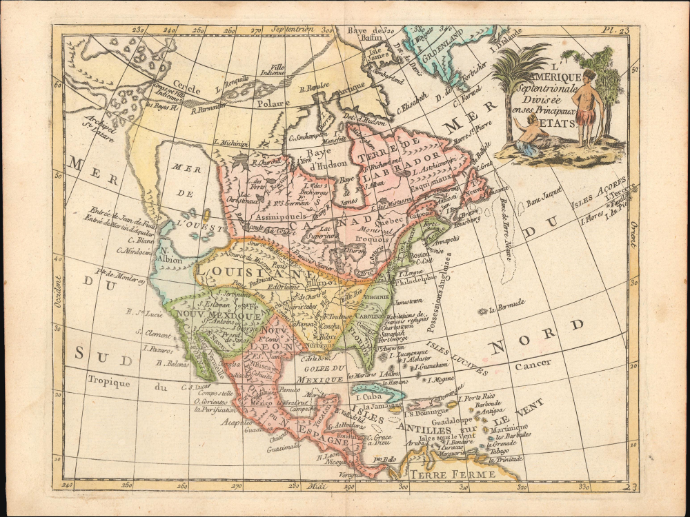
L'Amérique Septentrionale Divisée en ses Principaux Etats.
1781 (undated) 8 x 8.75 in (20.32 x 22.225 cm) 1 : 43000000
1781 (undated) 8 x 8.75 in (20.32 x 22.225 cm) 1 : 43000000
Description
This is Joseph de Laporte's c. 1781 map of North America, prepared for his Atlas Moderne Portatif. It is notable for containing a very large apocryphal 'Sea of the West' and a presumed Northwest Passage cutting through Canada based on the 'discoveries' of the mythical Admiral de Fonte.
A Closer Look
This curious map stretches from Baffin Bay to the Caribbean. Settlements are noted throughout, including a seeming reference to French Huguenot refugees in the Carolinas, as are forts, Native American groups, waterways, mountains, islands, and sandbanks. Territories are color-shaded, though in a curious manner; for instance, 'New Mexico,' including the Californias, is shaded differently than the rest of New Spain (Mexico). The most noticeable aspects of the map, however, are the large 'Sea of the West' in the Pacific Northwest and the presumed Northwest Passage between Baffin Bay and the 'Archipel St. Lazare.'The Sea of the West
By far the most interesting aspects of this map deal with its treatment of the largely unexplored Pacific Northwest. A tremendous body of water, called the 'Mer de l'Ouest,' occupies the greater part of the northwestern portion of the continent. This body of water was speculated by Philippe Buache and Joseph Nicolas De l'Isle in the early 18th century based upon wishful thinking, the somewhat questionable 16th-century explorations of Juan de Fuca, and the utterly fraudulent explorations of the imaginary Admiral De Fonte. De Laporte gives the Mer de l'Ouest its fullest expression, though he stops just short of connecting it to either the network of lakes and rivers extending westward from Hudson Bay or to the similar network extending westward from Lake Superior.The Apocryphal Admiral de Fonte
Further north, we can find traces of Admiral de Fonte's apocryphal discovery of a passage from the Pacific (starting at the Archipel St. Lazare) eastward via a network of lakes and rivers to Baffin Bay. The De Fonte legend first appeared in a 1706 English publication entitled Memoirs of the Curious. This short-lived magazine published a previously unknown account by a supposed Spanish Admiral named Bartholomew de Fonte. De Fonte is said to have sailed up the Pacific coast of North America in 1640. On this voyage, he apparently discovered a series of gigantic lakes, seas, and rivers heading eastward from the Pacific towards Hudson Bay. The De Fonte story relates how, on one of these great inland lakes, he met with a westward-bound ship from Boston that must have come through the Northwest Passage. Today, based on inaccuracies and falsities, we know the entire De Fonte article to have been a fabrication. However, it set 18th-century society afire with speculation that a Northwest Passage must indeed exist. Even such luminaries as Benjamin Franklin wrote long defenses of De Fonte. Our map offers an uncommon variant on the De Fonte passage, positioning its western entrada well to the north in order to accommodate the Sea of the West and situating its outlet at Baffin rather than Hudson Bay.Publication History and Census
This map was prepared for the Atlas Moderne Portatif, published by Joseph de Laporte in several editions between 1780 and 1802, the maps of which may have been prepared by Robert de Vaugondy or Jean Baptiste Bourguignon d'Anville, though this is not certain. It draws heavily from Jean Janvier's map of the same title, first issued in 1762 and reprinted in multiple states in the following years. The map is only independently cataloged as part of the holdings of the Bibliothèque nationale de France in the OCLC, while the entire atlas is more widely distributed in institutional collections.Source
de Laporte, J. et al, Atlas moderne portatif, composé de vingt-huit cartes sur toutes les parties du globe terrestre, (Paris: Chez Laporte) 1781.
Condition
Very good. Light wear along original fold lines. Light foxing in margins.
References
OCLC 494181479 (1786 printing).