This item has been sold, but you can get on the Waitlist to be notified if another example becomes available, or purchase a digital scan.
1830 Lapie Map of North America and the United States
AmeriqueSeptentrionale-lapie-1829$112.50

Title
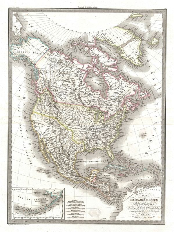
Carte de l'Amerique Septentrionale.
1830 (dated) 22 x 16 in (55.88 x 40.64 cm)
1830 (dated) 22 x 16 in (55.88 x 40.64 cm)
Description
A fine first edition example of M. Lapie's 1830 map of North America. The map covers the entire North American continent from the North Pole and Arctic Ocean to Panama and from the Pacific Ocean to the Atlantic Ocean. The map shows Greenland, Russian America, New Britain, Canada, Unites States, Mexico, Guatemala, Bahamas, Cuba and Haiti. An insert in the lower left corner details the Bering Sea and the Aleutian Islands. During this time in history, United States was rapidly expanding. Canada saw an increase in British settlements and was facing a division between its French and British communities. This ultimately led to a rebellion in 1837 an 1838. There were tensions in Mexico due to the rebellion of the english speaking region of Texas and the tension between the liberals and the conservatives. This map was engraved by Armand Joseph Lallemand as plate no. 42 in the first edition of M. Lapie's important Atlas Universel. This map, like all maps from the Atlas Universel features an embossed stamp from the Lapie firm.
CartographerS
Pierre M. Lapie (fl. 1779 - 1850) and his son Alexandre Emile Lapie (fl. 1809 - 1850) were French cartographers and engravers active in the early part of the 19th century. The Lapies were commissioned officers in the French army holding the ranks of Colonel and Capitan, respectively. Alexander enjoyed the title of "First Geographer to the King", and this title appears on several of his atlases. Both father and son were exceptional engravers and fastidious cartographers. Working separately and jointly they published four important atlases, an 1811 Atlas of the French Empire (Alexander), the 1812 Atlas Classique et Universel (Pierre), the Atlas Universel de Geographie Ancienne et Modern (joint issue), and the 1848 Atlas Militaire (Alexander). They also issued many smaller maps and independent issues. All of these are products of exceptional beauty and detail. Despite producing many beautiful maps and atlases, the work of the Lapie family remains largely underappreciated by most modern collectors and map historians. The later 19th century cartographer A. H. Dufour claimed to be a student of Lapie, though it is unclear if he was referring to the father or the son. The work of the Lapie firm, with its precise engraving and informational density, strongly influenced the mid-19th century German commercial map publishers whose maps would eventually dominate the continental market. More by this mapmaker...
Armand Joseph Lallemand (c. 1810 - 1871) was an engraver and map publisher based in Paris during the mid-19th century. Most of Lallemand's work focused on landscapes and building vies, though he did take part in a few cartographic ventures, including the production of an atlas with Alexandre Emile Lapie and several tourist pocket maps of Paris. Learn More...
Source
Lapie, M., Atlas Universel de Geographie. Ancienne et Moderne, precede d'un Abrege de Geographic Physique et Historique…, 1829. (Rumsey identifies this as the first edition of Lapie's Atlas Universel. In all known examples, the title page is dated 1829 while the maps are dated variously to 1833 - suggesting that the first issue of this atlas was 1833, not 1829.)
Condition
Very good. Original platemark visible. Blank on verso. Original centerfold.
References
Rumsey 2174.042. Phillips (Atlases) 754, 765.