This item has been sold, but you can get on the Waitlist to be notified if another example becomes available, or purchase a digital scan.
1682 Visscher Map of Southern Spain and the Strait of Gibraltar
AndaluciaValencia-visscher-1682$1,250.00

Title
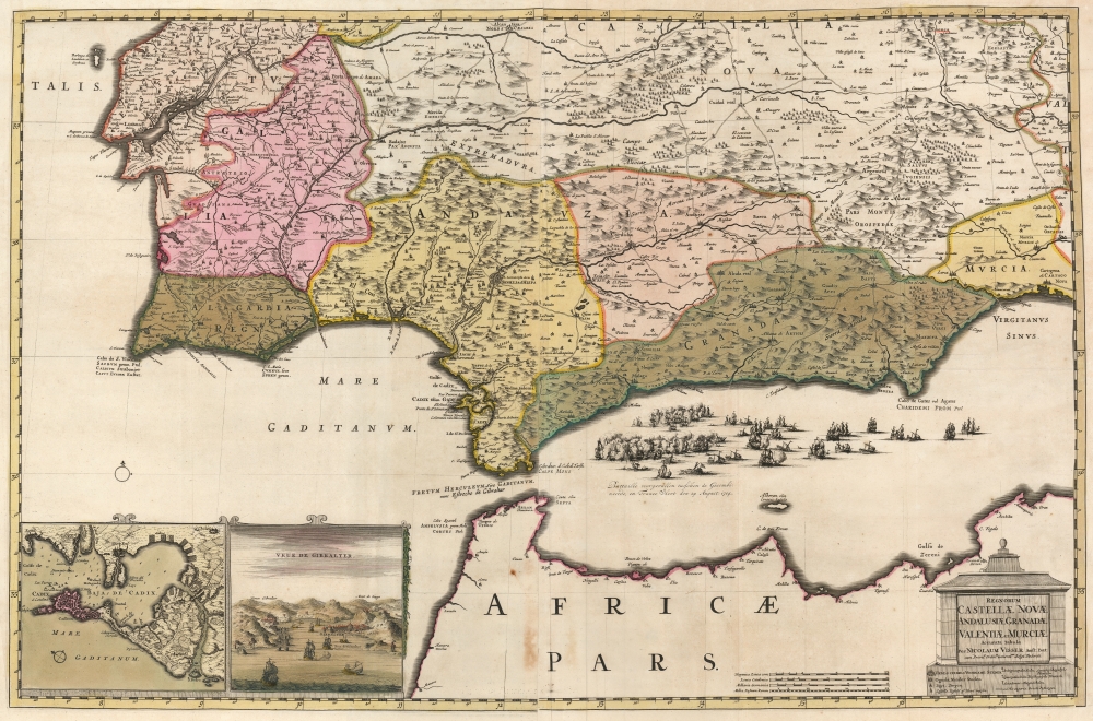
Regnorum Castellæ Novae Andalusiae Granadae Valentiae et Murciae Accurata Tabula.
1682 (dated) 21.25 x 32.5 in (53.975 x 82.55 cm) 1 : 1000000
1682 (dated) 21.25 x 32.5 in (53.975 x 82.55 cm) 1 : 1000000
Description
This is a beautiful example of Nicolaes Visscher II's 1682 map of southern Spain and Portugal, and the Strait of Gibraltar. This is the c. 1710 state of the map, highlighting the crucial ports of Cadiz and Gibraltar and including a dramatically engraved portrayal of the August 24, 1704, Battle of Málaga.
Updated for Current Events
Although the bulk of the map's detail dates to 1682, the map was reworked to enhance its relevance to the War of the Spanish Succession, which overtook Europe between 1701 and 1715 (although active campaigns were mainly confined between 1701-1709). The various European powers entered the war with differing goals: the area portrayed in the present map was the primary theatre of England's efforts (with Dutch support) to wrest control over the Mediterranean. The English, allied with the Dutch, had captured Gibraltar in the first days of August 1704. The French moved to attempt the recapture of the port and were engaged by the Anglo-Dutch off the Spanish coast of Málaga on August 24, 1704. After a long, hotly fought engagement, the Anglo-Dutch withdrew to Gibraltar. Nevertheless, the French fleet returned to port at Toulon and remained there for the rest of the war. Spain would lay siege to the fortress city in 1705, to no avail. Thus, strategically, the battle was a defeat for the French. England, ending the war with Gibraltar in hand and with France effectively abandoning control of the Mediterranean, had achieved their primarily goals in the war.Depicting a Battle
The vigorously-fought battle is portrayed in sharp detail, with the lines of battle shrouded in smoke, sinking ships surrounded by sailors clinging to the wreckage, and with French galleys towing damaged ships out of the line. This depiction emphasizes the idea of a French withdrawal, which while not being technically accurate in the short term did actually reflect the end result of the fight.Scope of the Map
The map's geographic reach extends from the coast of Africa in the south to the course of the Tagus River in the north and from the Iberian Atlantic coast in the west to the Murcia region in the east. It is centered on the kingdom of Andalusia, and specifically on the city of Seville. Mountains are depicted pictorially, and provinces are distinguished with original outline and wash color. In addition to Seville, many other cities such as Cadíz, Lisbon, and Cordoba, appear.Publication History and Census
This map - two printed sheets, joined - was engraved in 1682, intended as part of a six-sheet map of the Iberian Peninsula. As such, the plates were engraved without a complete border at the top and right, where they were to be joined to their neighboring maps. We have seen several examples issued, as here, with printed borders pasted down to present the map as a separate. The first state of this map lacked either of the lower left insets. A second state (dated variously from 1698 to 1702) introduced the chart of the bay of Cadiz. At some point after 1704 both the view of Gibraltar and the portrayal of the Battle of Malaga was added; the present example is of this latter state. We see three examples of this state clearly identified in institutional collections, although other examples of this state are catalogud with impossible dates in OCLC. Visscher does not appear to have had these as part of a regular atlas, but they do occasionally appear in composite atlases of the latter 17th century and early 18th century, such as that of Danckerts.Cartographer
Nicolaes Visscher II (September 30, 1649 – May 31, 1702) was a Dutch engraver, cartographer and publisher: he was born into the trade, the son of Nicolaes Visscher I and the grandson of Claes Janszoon Visscher. He produced a number of maps to add to the family atlas, as well as for inclusion in other composite atlases. After his death, his wife, Elisabeth, continued the family tradition of mapmaking and publishing. The plates and remaining stock were then sold to Peter Schenk, who reprinted them under his own name. More by this mapmaker...
Condition
Very good. Two sheets joined, with right and top borders pasted down as issued, with handsome original outline and wash color. Few marginal mends, else excellent.
References
OCLC 925490678.