This item has been sold, but you can get on the Waitlist to be notified if another example becomes available, or purchase a digital scan.
1712 Wells Map of Ancient Macedonia and the Balkans (Thrace)
AntientThrace-wells-1712$175.00

Title
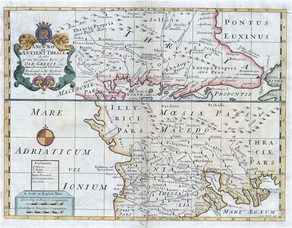
A New Map of Antient Thrace: As also of the Northern Parts of Old Greece, viz. Macedonia, and Thessalia.
1712 (undated) 15 x 19.5 in (38.1 x 49.53 cm) 1 : 1800000
1712 (undated) 15 x 19.5 in (38.1 x 49.53 cm) 1 : 1800000
Description
This is a beautiful 1712 map of ancient Thrace or Northern Greece and Bulgaria. Essentially divided into two panels, the top panel depicts from north eastern Greece, with parts of Macedonia and Thrace, to Bulgaria and the Black Sea. The lower map features north western Greece, including Thessalia and parts of Macedonia, to southern Albania. It notes towns, cities, rivers, mountains, islands and other topographical features. The map identifies a host of important cities and towns and uses ancient names throughout.
Following the Battle of Corinth in 146 BC, the Greek peninsula came under Roman rule. The period from 31 BC and AD 180 in Greek history is described as the era of the Pax Romana. This was a period of peace and security when many Greek cities flourished, leading to cultural and economic progress. The classical period in Greek history, which lasted from the 5th century B.C. through the 4th century B.C. greatly influenced the Roman Empire's politics, art, architecture, philosophy and literature. After the fall of the Western Roman Empire, Greece became the center of the Eastern Roman or Byzantium Empire.
A decorative cartouche appears on the top left quadrant of the map featuring the coat of arms of the Duke of Gloucester. This, like many other Wells maps, is dedicated to Prince William, Duke of Gloucester and son of Queen Anne, who, when this map was being prepared, was a student at Oxford. Engraved by Sutton Nicholls and published by T. Bonwicke for the 1712 edition of Edward Wells' Atlas, A New Sett of Maps both of Ancient and Present Geography.
Cartographer
Edward Wells (1667 - 1727) was an English mathematician, geographer, and classical scholar based at Christ Church College, Oxford. Wells trained for the ministry but quickly found himself unsuited to religious life and instead applied for an academic position at Oxford, where he authored numerous well respected works on a wide range of mathematical and scientific topics. He tutored Prince William, the sickly son of Queen Anne, who was likely about 11 at the time this map was prepared. Wells dedicated nearly all of the maps in his atlas, A New Sett of Maps both of Ancient and Present Geography, to the young prince - quite possibly posthumously, as William died in July of 1700 shortly prior to the publication of the atlas. Nonetheless, Wells' geography proved popular and was published in number editions well into the 1730s. More by this mapmaker...
Source
Wells, E., A New Sett of Maps both of Ancient and Present Geography, (London, T. w. Bonwicke) c. 1712.
A New Sett of Maps both of Ancient and Present Geography was published by Edward Wells in various editions between 1701 and 1730. The publication contained some 40 maps all of which were dedicated to Prince William, Duke of Gloucester. Wells tutored the young prince at Christchurch, Oxford and seems to have developed a close relationship with him. At just 11 years of age, William died in 1700 and never had the opportunity to see the published work that he inspired. The atlas was intended for educational purposes with a focus on school use.
Condition
Very good. Some wear and toning along original centerfold. Minor spotting.
References
OCLC Number: 11807008.