This item has been sold, but you can get on the Waitlist to be notified if another example becomes available, or purchase a digital scan.
1867 Weyss Map of the Battle of Antietam during the American Civil War
Antietam-weyss-1867$325.00

Title
Antietam.
1867 (dated) 23 x 26.5 in (58.42 x 67.31 cm) 1 : 21120
1867 (dated) 23 x 26.5 in (58.42 x 67.31 cm) 1 : 21120
Description
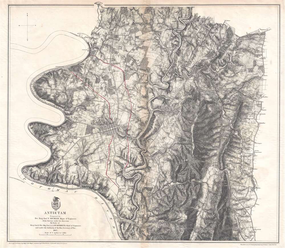
This is an 1867 John Weyss and Nathaniel Michler map of the battlefield of Antietam in Maryland. The map depicts the region from the Potomac River to Rohrersville and from Bakersville to just south of the Antietam Iron Works situated at the confluence of Antietam Creek and the Potomac River.
The Battle of Antietam
The single bloodiest day in U.S. history, the battle of Antietam claimed a combined total of 22,717 killed, wounded, or missing and has the distinction of being the first field army level engagement in the Eastern Theater of the Civil War to take place on Union soil. The battle was fought between Confederate General Robert E. Lee's Army of Northern Virginia and Union General George B. McClellan's Army of the Potomac near Sharpsburg, Maryland and Antietam Creek. The battle is referred to by both names, although the Battle of Sharpsburg is used primarily in the southern United States. Who emerged victorious from the Battle of Antietam is a difficult question, since both sides suffered huge numbers of casualties and each side had something to celebrate. The Union Army successfully stopped the Confederate invasion of Maryland but was unable to capitalize on any advantage won during the battle to completely defeat Lee's army. As such, Lee was able to retreat with his army back across the Potomac and live to fight another day. Historians deem this to be a strategic victory for the Union. Perhaps the most significant outcome of the battle, however, was Lincoln's decision to follow the victory by announcing the Emancipation Proclamation, which prevented both England and France from pursuing any plans to officially recognize the Confederacy.A Closer Look at the Map
A highly detailed survey of the region, much of the map minimizes the events of the battle itself in order to provide a more thorough understanding of the terrain. Confederate lines of battle from September 16th, 1862 and the evening of September 17, 1862 are illustrated in red ink on the left side, but Union positions are not shown. The only other notation referring to the war is the National Cemetery outside Sharpsburg, which today is known as Antietam National Cemetery. The cemetery was commissioned in 1865 and internments began in 1867. The only Civil War era soldiers buried at Antietam were Union soldiers, Confederate dead were buried at three other cemeteries around Maryland. The cemetery also contains the graves of veterans from the Spanish-American War, both World Wars, and the Korean War. Sharpsburg is by far the largest community in the area, with several small hamlets noted to the north. Numerous homesteads are also marked throughout. Roads, including the Sharpsburg and Boonsboro Turnpike, are noted, as is the Chesapeake and Ohio Canal which runs along the Potomac River.Publication History and Census
This map was surveyed and drawn by Major John E. Weyss under the command of Nathaniel Michler engraved by Julius Bien, and published by the War Department in Military Maps illustrating the Operations of the Armies of the Potomac and James in 1869. While this map is well represented in institutional collections, it is rarely on the private market.CartographerS
John E. Weyss (1820 - June 24, 1903) was an Austrian-American illustrator, cartographer, and engineer. Born in Vienna, Weyss immigrated to the United States in 1848 and settled in New York. He served as a member of the U.S. Government's Mexican Boundary Survey (1849 - 1855), led by Major William Hemsley Emory, because of his training as an illustrator. In the capacity of a civilian artist working for the army, Weyss contributed several illustrations for Emory's report, which was published in 1857-59. Weyss is also credited on eleven of the report's maps. At the outbreak of the American Civil War, Weyss held a position as a civil engineer for the state of Kentucky. Weyss received a commission as a major from the Governor of Kentucky and, due to his professional experience, was assigned to the staff of Captain Nathaniel Michler, the chief topographical officer in the Army of the Ohio. In this role he did survey work for maps of the vicinity of Shiloh and Corinth, both sites of major Civil War battles. Weyss then joined Captain Michler when he moved to the staff of General Rosecrans in late 1862, for whom they made a series of maps of the Battle of Stones River. Weyss and Michler were then transferred to the Army of the Potomac in May, 1863. One of Weyss's first assignments for the Army of the Potomac was a map of the vicinity of Harper's Ferry, Virginia, for which he produced a highly detailed map of the very complex topography of the region. Soon, Weyss was made responsible for the day-to-day detailed mapping during the siege at Petersburg. After the war, Weyss served as the principal surveyor under the direction of Michler during the creation of the atlas Military maps illustrating the operations of the armies of the Potomac and James, May 4th 1864 to April 9th 1865, that was published in 1869. Weyss served the U.S. Army Corps of Engineers for another twenty years, until he retired sometime in the 1880s. Weyss died on June 4, 1903, in Washington, D.C. More by this mapmaker...
Nathaniel Michler (September 13, 1827 - July 17, 1881) was an American military officer and mapmaker who served during the American Civil War. Born in Easton, Pennsylvania, Michler attended West Point, from which he graduated seventh in his class. Commissioned as a 2nd Lieutenant in the Topographical Engineers, Michler participated in the Mexican Boundary Survey from 1851 until 1857, when he was transferred to serve as the chief topographical engineer in surveys for a proposed canal from the Gulf of Darien to the Pacific Ocean from 1858 until 1860. He held the rank of Captain at the outbreak of the American Civil War and served with the Army of the Cumberland from 1861 - 1863, then was transferred to the Army of the Potomac and built defensive works for the Union Army at the Battles of the Wilderness, Spotsylvania, Cold Harbor, and Petersburg. He was promoted to Colonel in August 1864 and brevetted Brigadier General in April 1865. After the war, Michler served as superintendent in the District of Columbia until 1871 and from 1872 to 1875 was chief engineer with the General Commanding Division of the Pacific. He acted as military attaché for the United States Legation in Vienna, Austria from 1878 to 1880. Learn More...
Julius (Julien) Bien (September 27, 1826 - December 21, 1909) was a German-Jewish lithographer and engraver based in New York City. Bien was born in Naumburg, Germany. He was educated at the Academy of Fine Arts, Cassell and at Städel's Institute, Frankfurt-am-Main. Following the suppression of the anti-autocratic German Revolutions of 1848, Bien, who participated in the pan-German movement, found himself out of favor in his home country and joined the mass German immigration to the United States. Bien can be found in New York as early as 1849. He established the New York Lithographing, Engraving & Printing Company in New York that focused on the emergent chromo-lithograph process - a method of printing color using lithographic plates. His work drew the attention of the U.S. Government Printing Office which contracted him to produce countless government maps and surveys, including the Pacific Railroad Surveys, the census, numerous coast surveys, and various maps relating to the American Civil War. Bien also issued several atlases both privately and in conjunction with a relation, Joseph Bien. At the height of his career Bien was elected president of the American Lithographers Association. After his death in 1909, Bien's firm was taken over by his son who promptly ran it into insolvency. The firm was sold to Sheldon Franklin, who, as part of the deal, retained the right to publish under the Julius Bien imprint. In addition to his work as a printer, Bien was active in the New York German Jewish community. He was director of the New York Hebrew Technical Institute, the New York Hebrew Orphan Asylum, and president of the B'nai B'rith Order. Learn More...
Source
War Department, Military Maps illustrating the Operations of the Armies of the Potomac and James May 4th 1864 to April 9th 1865 including Battlefields of the Wilderness, Spottsylvania, Northanna, Totopotomoy, Cold Harbor, The Siege of Petersburg and Richmond Battlefields of Five Forks, Jetersville and Sailor's Creek, Highbridge, Farmville, and Appomattox Court-House. (Washington) 1869.
Military Maps Illustrating the Operations of the Armies of the Potomac and James, published in 1869, compiled all the maps created by Major Nathaniel Michler and Major John E. Weyss of all the major battlefields of the eastern theater of war during the American Civil War. These maps blended together surveys done by soldiers both before and during battles and work done by Weiss and his team of engineers after the war was over. Many of these maps were reduced in order to be republished in the Atlas to Accompany the Official Records of the Union and Confederate Armies, which has become the standard reference for Civil War military maps.
Condition
Very good. Toning and light wear along original centerfold. Verso repairs to margin tears. Blank on verso.
References
Rumsey 3881.015. OCLC 70282046.