1832 Delamarche Map of the Settlement of the Children of Noah after The Flood
ApresDeluge-delamarche-1832$225.00

Title
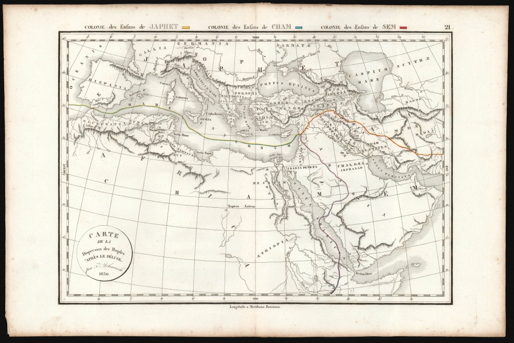
Carte de la Dispersion des Peuples 'Après le Déluge. Par Fx. Delamarche 1830.
1832 (undated) 11 x 17 in (27.94 x 43.18 cm) 1 : 19000000
1832 (undated) 11 x 17 in (27.94 x 43.18 cm) 1 : 19000000
Description
This is an elegantly-engraved map of the ancient world, depicting the resettlement of the children of Noah after the Biblical flood. It was printed in 1832 by Felix Delamarche.
A Closer Look
The map focuses on the part of the world framing the Mediterranean Sea, the Red Sea, and the Fertile Crescent: from Spain and the Strait of Gibraltar in the west to the mouth of the Gulf of Aden in the east; and from the source of the Blue Nile at Lake Tana in the south to the Danube, the Black Sea, and the Caspian Sea in the north. These lands are divided in three portions, with original hand-colored borders, indicating the lands settled by Ham, Shem, and Japheth - the sons of Noah - after the Great Flood had depopulated the world in the Biblical era, largely as interpreted by Josephus in the first century CE. The region of the Fertile Crescent, Arabia, and Africa east of the Red Sea is shown as the land of Shem. The region north of this, and of the Mediterranean, is shown as the land of Japheth. Africa, northwestern Arabia, and the land of Canaan are all indicated as Ham's portion.Ancient Names, Modern Geography
While the places named, and the territorial divisions here come from ancient history and Biblical interpretation, the map's topography is current to the first part of the 19th century. Its purpose there is to set the Biblical narrative in a modern cartographic context. This impulse was not new - the earliest printed maps of the world focused on the idea of a tripartite world, based both on its division between Noah's children as well as the conventions set by Ptolemy's first-century description of the world. What has changed by the time Delamarche produced this map is that there is no claim being made that the entirety of the world was populated directly by Noah's progeny: the focus is strictly on the part of the world whose Biblical locations can be definitively fixed in known geographical locations. For example, there is no claim (such as appeared in the 1571 Montanus world map) that the sons of Shem made their way to the New World.Publication History and Census
This map was prepared for issue as plate no. 21 in Felix Delamarche's 1832 Atlas de La Geographie Ancienne, du moyen age, et modern…. The map appears on the market from time to time, although it is somewhat neglected by institutional collections, with only two copies cataloged in the Bayerische Staatsbibliothek and the Universitat Autonoma de Barcelona.Cartographer
Charles-François Delamarche (August 1740 - October 31, 1817) founded the important and prolific Paris-based Maison Delamarche map publishing firm in the late 18th century. A lawyer by trade, Delamarche entered the map business with the 1787 acquisition from Jean-Baptiste Fortin of Robert de Vaugondy's map plates and copyrights. Delamarche appears to have been of dubious moral character. In 1795, the widow of Didier Robert de Vaugondy, Marie Louise Rosalie Dangy, petitioned a public committee for 1500 livres, which should have been awarded to her deceased husband. However, Delamarche, proclaiming himself Vaugondy's heir, filed a simultaneous petition and walked away with the funds, most of which he was instructed to distribute to Robert de Vaugondy's widow and children. Just a few months later, however, Delamarche proclaimed Marie Dangy deceased, and it is highly unlikely that any funds found their way to Robert de Vaugondy's impoverished daughters. Nonetheless, where Robert de Vaugondy could barely make ends meet as a geographer, Delamarche prospered as a map publisher, acquiring most of the work of earlier generation cartographers Lattre, Bonne, Desnos, and Janvier, thus expanding significantly upon the Robert de Vaugondy stock. Charles Delamarche eventually passed control of the firm to his son Felix Delamarche (c. 1750 - c. 1850) and geographer Charles Dien (1809 - 1870). It was later passed on to Alexandre Delamarche, who revised and reissued several Delamarche publications in the mid-19th century. The firm continued to publish maps and globes until the middle part of the 19th century. More by this mapmaker...
Source
Atlas de La Geographie Ancienne, du moyen age, et moderne, adopte par le Conseil Royal de L'Instruction Publique, A l'usage desColleges Royaux et des Maisons d'Education, pour suivre les Cours de Geographie et D'Histoire…, 1832.
Condition
Very good condition. Some toning and spotting in margins. Original outline color.
References
OCLC 165453559.