This item has been sold, but you can get on the Waitlist to be notified if another example becomes available, or purchase a digital scan.
1811 Cary Map of Arabia, Egypt & Abyssinia
Arabia-cary-1811$200.00

Title
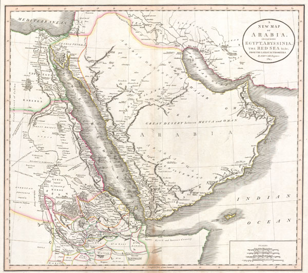
A New Map of Arabia, including Egypt, Abyssinia, the Red Sea & c. & c. from the latest Authorities.
1811 18 x 21 in (45.72 x 53.34 cm)
1811 18 x 21 in (45.72 x 53.34 cm)
Description
This is a stunning 1811 map of Arabia, Egypt and Abyssinia ( Ethiopia ) by English Cartographer John Cary. A smorgasbord of wonderful detail including historical notes, caravan routes, the locations of desert wells and oases, nautical routes, and tribal kingdoms. Contains such notations as 'Here the Portuguese found King David encamped in the Year 1520' , referring to the Portuguese embassy to the King of Ethiopia; 'Myrrh and Incense Country' on the Horn of Africa; and 'Supposed Island of Meroe,' referring to the ancient pyramid building culture in the heard of what is today Sudan. Also of interest is the route of the Frigate 'La Venus,' which charted the Red Sea, the Persian Gulf, and the Indian Ocean before disappearing in a hurricane with all crew and cargo in 1788. Dated 1811.
Cartographer
John Cary (1754 - 1835) was a London based cartographer active in the early part of the 19th century. Ronald Vere Tooley, the prominent English map historian, writes of Cary, "As an engraver he was elegant and exact with fine clear lettering and great delicacy of touch." Cary began his work as an engraver, cartographer, and globe maker in 1776 with his New and Correct English Atlas. This important atlas represented a new phase in cartography where accuracy and detail rose in prominence over the decorative embellishments of the 18th century. This change was indicative of the times when travel and commerce were expanding globally as never before. Cary's mastery of both engraving and cartography resulted in a series of seminal works that redefined mapmaking in the early 19th century. His stupendous Cary's New Universal Atlas, published in 1808, set the standard for all cartographers who followed. Cary reissued this seminal atlas in 1811, 1819, 1824, 1828, 1833, 1836 and 1844. Cary also did considerable work on the English Ordinance Survey prior to 1805. His cartographic work particularly inspired the Edinburgh school of cartography as represented by John Pinkerton and John Thomson. In America, Cary's work was used as the basis for Tanner's important New American Atlas. Cary's last published atlas appeared posthumously in 1844, however, by 1850 Cary's work was being carried on by his sons and other well-known cartographers including James Wyld, John Tallis & Company, and Crutchley. More by this mapmaker...
Condition
Very good condition with wide clean margins. Minor discoloration on bottom centerfold – see photo. Original platemark visible. Blank on verso.
References
Phillips, 714; Fordham, J.C. John Cary, p. 77-82; The map collector, 43, p. 40-47; National Maritime Museum. Catalog, v. 3, no. 311; Rumsey 1657.047.