This item has been sold, but you can get on the Waitlist to be notified if another example becomes available, or purchase a digital scan.
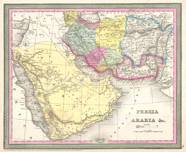
1850 Mitchell Map of Arabia, Persia, Afghanistan
Arabia-mitchell-1850$75.00

Title
Persia, Arabia & C.
1850 (dated) 12.5 x 15.5 in (31.75 x 39.37 cm)
1850 (dated) 12.5 x 15.5 in (31.75 x 39.37 cm)
Description
A fine example of S. A. Mitchell Sr.'s important c. 1850 map of Arabia, Persia, and Afghanistan. Covers the region from the Mediterranean and Red Sea eastward as far as India, including all of modern day Saudi Arabia, Israel, Jordan, Syria, Iran, Iraq, Kuwait, Afghanistan, and parts of Pakistan. Cartographically this is an enlarged, updated, and revised version of a similar map first issued by Tanner in 1836. Mitchell offers a wealth of detail throughout, identifying mountains, deserts, rivers, springs, caravan routes, cities, towns, forts, and an assortment of additional political and topographical elements. Map is hand colored in pink, green, yellow and blue pastels to define national and regional boundaries. Dated and copyrighted: '1850 by Thomas Cowperthwait & co. in the Clerk's office of the District Court of the Eastern District of Pennsylvania.' Published by S. A. Mitchell for inclusion as plate no. 68 in the c. 1850 edition of his New Universal Atlas
Cartographer
Samuel Augustus Mitchell (March 20, 1792 - December 20, 1868) began his map publishing career in the early 1830s. Mitchell was born in Bristol, Connecticut. He relocated to Philadelphia in 1821. Having worked as a school teacher and a geographical writer, Mitchell was frustrated with the low quality and inaccuracy of school texts of the period. His first maps were an attempt to rectify this problem. In the next 20 years Mitchell would become the most prominent American map publisher of the mid-19th century. Mitchell worked with prominent engravers J. H. Young, H. S. Tanner, and H. N. Burroughs before attaining the full copyright on his maps in 1847. In 1849 Mitchell either partnered with or sold his plates to Thomas, Cowperthwait and Company who continued to publish the Mitchell's Universal Atlas. By about 1856 most of the Mitchell plates and copyrights were acquired by Charles Desilver who continued to publish the maps, many with modified borders and color schemes, until Mitchell's son, Samuel Augustus Mitchell Junior, entered the picture. In 1859, S.A. Mitchell Jr. purchased most of the plates back from Desilver and introduced his own floral motif border. From 1860 on, he published his own editions of the New General Atlas. The younger Mitchell became as prominent as his father, publishing maps and atlases until 1887, when most of the copyrights were again sold and the Mitchell firm closed its doors for the final time. More by this mapmaker...
Source
Mitchell Sr., S. A.,A New Universal Atlas Containing Maps of the various Empires, Kingdoms, States and Republics Of The World. (1850 issue)
Condition
Very good condition. A couple of minor verso repairs ot margins. Minor Spotting in Southern the southern part of the Arabian peninsula.
References
Rumsey 0537.066 (1946 edition). Phillips (atlases) 6103-65. Alai, C., General Maps of Persia 1477-1925, E-379.