1908 Ludwig Transportation Map of Argentina
ArgentinaFerrocarriles-ludwig-1908$950.00


Title
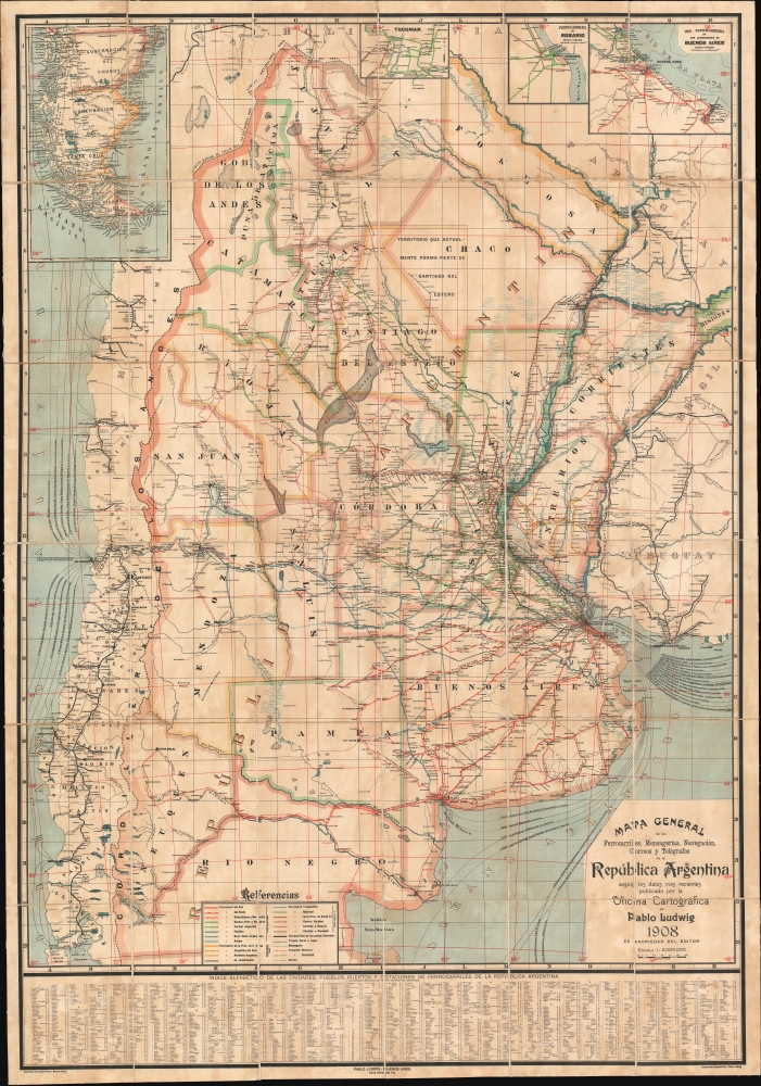
Mapa General de los Ferrocarriles, Mensagerias, Navegación, Correos y Telégrafos de la República Argentina.
1908 (dated) 53.75 x 37.75 in (136.525 x 95.885 cm) 1 : 2000000
1908 (dated) 53.75 x 37.75 in (136.525 x 95.885 cm) 1 : 2000000
Description
This is a 1908 Pablo Ludwig map of Argentina's railroad system. The map illustrates a period of prosperity and growth in Argentina that led to a massive expansion of the national railroad network.
Historical Context
Although railroad construction in Argentina began in the 1860s and saw rapid expansion throughout the late 19th century, the Baring Crisis, an acute global recession also known as the Panic of 1890, derailed progress. Nonetheless, by 1908, when this map was issued, the country was in the midst of another railroad boom, and trackage increased from roughly 9,000 km in 1890 to 29,000 km by 1910.A Closer Look
More than a dozen combinations of color and pattern differentiate railroad lines, all of which are labeled. Telegraph lines, mail routes, and maritime connections are also noted. Insets of the regions around Buenos Aires, Rosario, and Tucuman are situated along the top border, and an inset detailing southern South America and Tierra del Fuego occupies the upper left. An alphabetical index of hundreds of cities, towns, ports, and other locations is included along the bottom border.Publication History and Census
This map was created and published by Pablo Ludwig in 1908. We see no examples cataloged in any institutional collection, dealer catalogs, or auction records, making this the only known surviving example.Cartographer
Pablo Ludwig (fl. c. 1890 - c. 1962) was cartographer active in Buenos Aires in the late 19th and early 20th centuries. His office, the Oficina Cartográfica de Pablo Ludwig, published maps of Buenos Aires, regional maps of Argentina, and maps of Argentina as a whole. We have been unable to discover anything about his personal life or a detailed history of his firm. More by this mapmaker...
Condition
Very good. Dissected and mounted on linen as issued, with original boards present but separate. Some scuffing near fold areas, but overall excellent.