1964 Blake Clark Pictorial Map of Arizona
Arizona-clark-1964$2,250.00
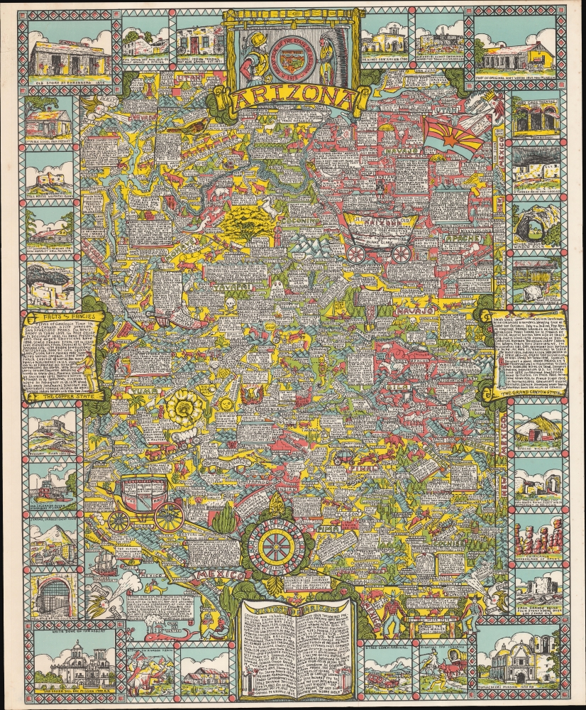

Title
A New Mappe of Ye Old Arizona mended anew in manie places and particularly surveyed according to ye newest and most exacting observations (from ye best) authorities and with humble apologies.
1964 (dated) 28 x 23 in (71.12 x 58.42 cm) 1 : 1270000
1964 (dated) 28 x 23 in (71.12 x 58.42 cm) 1 : 1270000
Description
This is an unrecorded 1964 pictorial map of Arizona (and surrounding states) by the well-known pictorial map maker Blake Edward Clark. Clark is best known for his 1926 maps of Boston, Washington D.C., and Philadelphia, making this map, issued some 40 years later, a curious outlier to his small but well-respected corpus.
A Closer Look
Coverage embraces all of Arizona as well as parts of adjacent states and Mexico. The map is dense with textual annotation and imaginative illustrations ranging from the historical to the ridiculous. The border is composed of decorative vignettes illustrating Arizona's historical and geological wonders, as well as various textual 'facts and fancies'. The map's title, easy to miss amidst the complexity, appears in the body of a Conestoga wagon in the upper right. The state seal is set at top-center, flanked by an armored conquistador and an American Indian Chief wearing a Comanche-style war bonnet. Curiously, Clark extends the map to the southwest to include the Sea of Cortez, possibly with the singular purpose of illustrating the Flying Dutchman, a legendary ghost ship, which he suggests might be looking for Arizona's most famous treasure, the Lost Dutchman Mine.Publication History and Census
This map was drawn and published in Arizona by Blake Edward Clark. It is the only known surviving example.Cartographer
Blake Everett Clark (June 22, 1900 - January 17, 1979) was an American artist. Born in Somerville, Massachusetts, the son of a stockbroker, Clark studied at Milton Academy (1917). ON graduation he went to France to serve in World War I (1914 - 1818) with the 301st Ambulance Detail Battery. On his return not the United States, he enrolled in Bowdoin College (1923), and Tufts College. He then moved to Paris where he studied art at the Académie Delécluse, Montparnasse. He returned to Boston by 1925, where he pursued a career in marine and landscape painting. During this time, he painted a second home in Ogunquit, Maine. While living in Boston, Clark collaborated with Edwin Birger Olsen (1902 - 1996) on a series of three pictorial maps: The Colour of An Old City: A Map of Boston Decorative and Historical (1926), A Kite View of Philadelphia and the Sesqui-Centennial International Exposition (1926), and Map of the City of Washington in the District of Columbia shewing the Architecture and History from the most Ancient Times down the Present (1926). He married Muriel Cooley in the 1930s, and settled in Brooklyn, New York, where he worked as an artist and a buyer at a department store. He disappears in subsequent decades, but reappears in Arizona in 1964, when he issued a pictorial map of that state, A New Mappe of Ye Old Arizona. He died in Maricopa, Arizona, in 1979. More by this mapmaker...
Condition
Very good. Repair tear, upper left corner.