This item has been sold, but you can get on the Waitlist to be notified if another example becomes available, or purchase a digital scan.
1938 Sundberg Pictorial Map of Fighting Between in East Asia Before WWII
ArmedTruce-sundberg-1938$100.00

Title
Armed Truce in the Far East.
1938 (dated) 15.25 x 22 in (38.735 x 55.88 cm) 1 : 7600000
1938 (dated) 15.25 x 22 in (38.735 x 55.88 cm) 1 : 7600000
Description
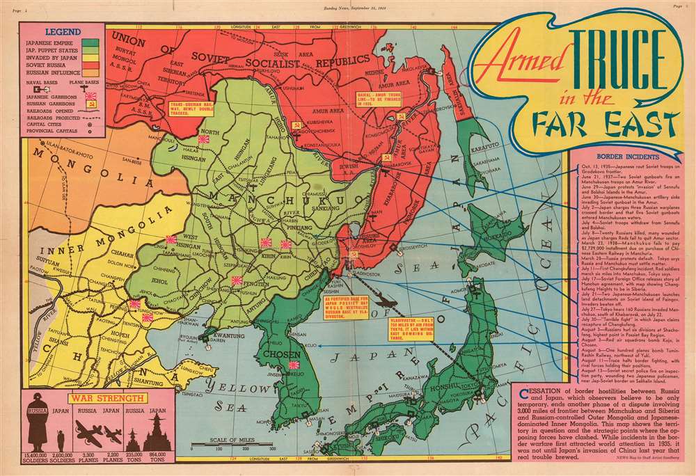
This is a 1938 Edwin L. Sundberg pictorial map of East Asia. Tracing 'border incidents' between the Russians and the Japanese from 1935 until 1938, the map depicts the region from Ulaanbaatar to the Pacific Ocean and from the Soviet Union to Kyushu.
Fighting between the Soviets and the Japanese
An index of the so-called 'border incidents', which amount to raids, small invasions, skirmishes, and other assorted hostilities, is situated along the right border. These events are broken up into nine different groups, some of which are made up of several of these happenings, while others are singled out. An arrow extends from each group and points to a location on the map, indicating the general vicinity of each event or series of events. While the title states that a truce has been brokered, that is in face the penultimate event in the list. The final occurrence is a firefight on Sakhalin between Japanese policemen and the Soviet secret police near the border between the Soviet and Japanese occupied zones of the island.A Closer Look at the Map
The Soviet Union and the Empire of japan are the focus of this map. The Soviet Union is shaded red, not surprising since red is the color associated with communism in the United States. The Japanese Empire, shaded green, includes Korea, which the Japanese ruled from 1910 until 1945 and called Chosen, as it is labeled here. Manchukuo, a puppet state of the Empire of Japan from 1932 until 1945, is shaded light green and is noted in the legend as a Japanese puppet state. The yellow areas are parts of the world that have been invaded by Japan, while the orange indicates territory under Soviet influence. Japanese and Soviet flags are placed throughout the map, noting the military garrisons of the opposing sides. Naval bases are marked by recently-fired shore guns, while air bases are marked by illustrations of airplanes. Numerous cities and towns are marked throughout, including Tokyo, Yokohama, Vladivostok, and Beijing (Peiping). A graphic situated in the lower left corner compares the relative military strength of Russia and Japan, making it clear that the Russians outnumber the Japanese in soldiers and airplanes, but that the Japanese have a strong naval advantage.Publication History and Census
This map was drawn by Edwin L. Sundberg and published by the Sunday News on September 25, 1938. Even though Sundberg's works were produced for a New York City newspaper, his maps vary in scarcity today. We have been unable to locate any other known examples of this map in institutional collections or on the private market.Cartographer
Edwin L. Sundberg (1898 - 1978) was an American cartographer known for his pictorial pieces. Sundberg was a staff artist for the Sunday News in New York City and eventually became Chief Cartographer in charge of a small staff of artists. More by this mapmaker...
Condition
Very good. Even overall toning. Wear along original fold lines. Closed margin tears professionally repaired on verso. Verso reinforcements. Text and printed photographs on verso.