
1968 Avaguian Pictorial Tourist Map of Armenia

This item has been sold.
Conservons Nos Monuments Historiques!
Encouraging the preservation of ancient architectural sites throughout Armenia.
Choose a Collection:
This Item
Enquire
Encouraging the preservation of ancient architectural sites throughout Armenia.
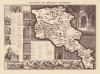
This is a 1968 Grigor Avagyan pictorial thematic map of Armenia celebrating the rich Armenian architectural heritage of tens of thousands of historical architectural monuments, some dating back as far as the 9th century BCE.A Closer Look
Coverage embraces Armenia as it existed in 1968 (and today), isolated from the surrounding countries. The nation is filled with pictorial vignettes representing specific historical monuments and ruins: pagan temples, monasteries, palaces, fortresses, obelisks, funerary monuments, and mausoleums. A comprehensive list appears to the left and below the map, segregated by region. In practice, this means the lowest numbers appear frequently, forcing the user to be attentive when seeking to correlate a vignette illustration with a site in the index. Awe-inspiring illustrations surround the map and the index. Some of these drawings, such as the view of the Zvartnots Cathedral in the lower left, present historical recreations. Others, like the view of the Ashtarak (Achtarak) Bridge, illustrate extant sites.Publication History and Census
This map was created by Grigor Avagyan and published in 1968. Two examples are cataloged in OCLC and are part of the institutional collections at the New York Public Library and the National Library of Israel.Cartographer
Grigor Avagyan (September 23, 1928 - December 4, 2005) was an Armenian politician. Born in Grozy, Russia, he attended Yerevan State University. Numerous works in Armenian attributed to him are cataloed in OCLC, along with a handful of maps. He died in Yerevan, Armenia on December 4, 2005. Further Details...
Condition
Very good. Extremely light wear along original fold lines.
References
OCLC 243591999.